Related Research Articles

Audlem is a village and civil parish located in the unitary authority of Cheshire East and the ceremonial county of Cheshire in North West England, approximately 7 mi (11 km) south of Nantwich. Close to the border with the neighbouring county of Shropshire, the village is eight miles (13 km) east of Whitchurch and seven miles (11 km) north of Market Drayton. According to the 2001 census, the population of the entire civil parish was 1,790, increasing to 1,991 at the 2011 Census.

Kelsall is a village and civil parish in the unitary authority of Cheshire West and Chester and the ceremonial county of Cheshire, England. It is located around 8 miles (13 km) east of Chester, 8 miles (13 km) west of Northwich and 4 miles (6 km) north west of Tarporley. The village is situated on Kelsall Hill, a part of the Mid-Cheshire Ridge, the broken line of sandstone hills that divide the west Cheshire Plain from its eastern counterpart. The ridge includes other hills including Peckforton, Beeston, Frodsham and Helsby.

Withington is a suburb of Manchester, Greater Manchester, England. Historically part of Lancashire, it lies 4 miles (6.4 km) from Manchester city centre, about 0.4 miles (0.6 km) south of Fallowfield, 0.5 miles (0.8 km) north-east of Didsbury and 1 mile (1.6 km) east of Chorlton-cum-Hardy. Withington has a population of just over 14,000 people, reducing at the 2011 census to 13,422.

Wilmslow Road is a major road in Manchester, England, running from Parrs Wood northwards to Rusholme. There it becomes Oxford Road and the name changes again to Oxford Street when it crosses the River Medlock and reaches the city centre.

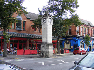
Wilmslow is a market town and civil parish in the unitary authority of Cheshire East in Cheshire, England, 11 mi (18 km) south of Manchester city centre. The population was 24,497 at the 2011 Census.

Cheadle is a borough constituency represented in the House of Commons of the Parliament of the United Kingdom.
Didsbury is a suburban village in Manchester, Greater Manchester, England, on the north bank of the River Mersey, 5 miles south of Manchester city centre. The population at the 2011 census was 26,788.

A civil parish is a country subdivision, forming the lowest unit of local government in England. There are 333 civil parishes in the ceremonial county of Cheshire, most of the county being parished. Cheshire East unitary authority is entirely parished. At the 2001 census, there were 565,259 people living in 332 parishes, accounting for 57.5 per cent of the county's population.

Cheadle is a village in the Metropolitan Borough of Stockport, Greater Manchester, England. Within the boundaries of the historic county of Cheshire, it borders Cheadle Hulme, Gatley, Heald Green and Cheadle Heath in Stockport, and East Didsbury in Manchester. In 2011, it had a population of 14,698.
Tatton is a constituency in Cheshire represented in the House of Commons of the UK Parliament since 2017 by Esther McVey, a Conservative.

The River Dean rises at Longclough in Macclesfield Forest on the western edge of the Peak District foothills above the village of Rainow in north east Cheshire, England.

Waverton is a village and civil parish on the outskirts of Chester in the unitary authority of Cheshire West and Chester and the ceremonial county of Cheshire, England. It lies about 3 miles (4.8 km) south-east of Chester High Cross, 19 miles (31 km) south of Liverpool and 33 miles (53 km) south west of Manchester. It is almost continuous with the village of Rowton to the north west and that in turn is almost continuous with Christleton. According to the 2011 Census, the population of the parish was 1,587.
Halton, formerly a separate village, is now part of the town of Runcorn, Cheshire, England. The name Halton has been assumed by the Borough of Halton, which includes Runcorn, Widnes and some outlying parishes.

Partington is a town and civil parish in the Metropolitan Borough of Trafford, Greater Manchester, England, ten miles (16 km) south-west of Manchester city centre. Within the boundaries of the historic county of Cheshire, it lies on the southern bank of the Manchester Ship Canal, opposite Cadishead on the northern bank. It has a population of 7,327.
Barthomley is a village and ancient parish, and is now a civil parish in the unitary authority of Cheshire East and the ceremonial county of Cheshire, England. According to the 2001 and the 2011 census' the parish had a population of 202. The village is situated near junction 16 of the M6 motorway and by the border with Staffordshire. It is about three miles south-west of Alsager.

Haslington is a village and civil parish in the unitary authority of Cheshire East and the ceremonial county of Cheshire, England. It lies about 2 miles (3.2 km) north-east of the much larger railway town of Crewe and approximately 4 miles (6.4 km) south of Sandbach. The village was originally bisected by the A534 road that links Crewe with Sandbach, however, this road has now been re-routed to bypass the village to the north-west. The village is also a close neighbour to a number of small towns and villages, and is approximately 6 miles (9.7 km) from the Elizabethan market town of Nantwich.

Handforth is a town and civil parish in Cheshire, England, 9 miles (14 km) south of Manchester city centre. The population at the 2011 census was 6,266. In the 1960s and 1970s, two overspill housing estates, Spath Lane in Handforth, and Colshaw Farm nearby in Wilmslow, were built to re-house people from inner city Manchester. It lies between Wilmslow, Heald Green, Stanley Green and Styal and forms part of the Greater Manchester Built-up Area.

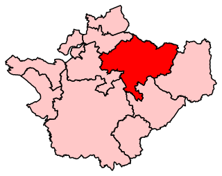
Cheshire East is a unitary authority area with borough status in the ceremonial county of Cheshire, England. The local authority is Cheshire East Council. Towns within the area include Crewe, Macclesfield, Congleton, Sandbach, Wilmslow, Handforth, Knutsford, Poynton, Bollington, Alsager and Nantwich. The council is based in the town of Sandbach.

Lindow Moss, also known as Saltersley Common, is a raised mire peat bog on the edge of Wilmslow in Cheshire, England. It has been used as common land since the medieval period and is best known for the discovery of the preserved bog body of Lindow Man in 1984.
Wilmslow Town Council is the town council for the Cheshire market town of Wilmslow and was established in May 2011 following a community governance review. It is the lowest tier of local government for the town and comprises 15 Councillors, all of whom work on a purely voluntary basis, supported by a Town Clerk, an Assistant Town Clerk and a Communications Officer.
References
- ↑ "Wilmslow Lacey Green ward population 2011". Neighbourhood Statistics. Office for National Statistics. Retrieved 15 March 2016.