
Cartography is the study and practice of making and using maps. Combining science, aesthetics and technique, cartography builds on the premise that reality can be modeled in ways that communicate spatial information effectively.
An atlas is a collection of maps; it is typically a bundle of maps of Earth or of a continent or region of Earth.

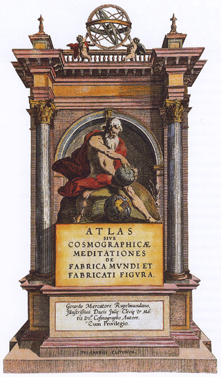
Gerardus Mercator was a Flemish geographer, cosmographer and cartographer. He is most renowned for creating the 1569 world map based on a new projection which represented sailing courses of constant bearing as straight lines—an innovation that is still employed in nautical charts.

Visconte Maggiolo, also spelled Maiollo and Maiolo, was a Genoese cartographer.

Fra Mauro, O.S.B. Cam., (c.1400–1464) was an Italian (Venetian) cartographer who lived in the Republic of Venice. He created the most detailed and accurate map of the world up until that time, the Fra Mauro map.

Carta marina et descriptio septemtrionalium terrarum is the first map of the Nordic countries to give details and place names, created by Swedish ecclesiastic Olaus Magnus and initially published in 1539. Only two earlier maps of the Nordic countries are known, those of Jacob Ziegler and Claudius Clavus.

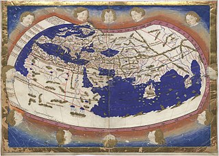
The Geography, also known by its Latin names as the Geographia and the Cosmographia, is a gazetteer, an atlas, and a treatise on cartography, compiling the geographical knowledge of the 2nd-century Roman Empire. Originally written by Claudius Ptolemy in Greek at Alexandria around 150 AD, the work was a revision of a now-lost atlas by Marinus of Tyre using additional Roman and Persian gazetteers and new principles. Its translation into Arabic in the 9th century was highly influential on the geographical knowledge and cartographic traditions of the Islamic world. Alongside the works of Islamic scholars – and the commentary containing revised and more accurate data by Alfraganus – Ptolemy's work was subsequently highly influential on Medieval and Renaissance Europe.
Jorge Reinel born in Lisbon was a Portuguese cartographer and instructor in cartography, son of the well-known cartographer Pedro Reinel. In 1519 in Seville he participated in the maps designed for the trip of his countryman Ferdinand Magellan, and his depiction of the Maluku Islands served as a basis for Spanish claims to the islands. He had trained many pupils in the art of cartography such as Portuguese Diogo Ribeiro.
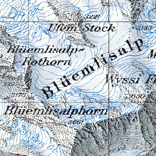
The cartography of Switzerland is the history of surveying and creation of maps of Switzerland. Switzerland has had its current boundaries since 1815, but maps of the Old Swiss Confederacy were drawn since the 16th century. The first topographical survey on a federal level began in 1809, resulting in the Topographic Map of Switzerland or Dufour Map. From 1869 to 1901, this map was replaced by the Topographic Atlas of Switzerland or Siegfried Map.
David Woodward was an English-born American historian of cartography and cartographer.

Giacomo Gastaldi was an Italian cartographer, astronomer and engineer of the 16th century. Gastaldi began his career as an engineer, serving the Venetian Republic in that capacity until the fourth decade of the sixteenth century. From about 1544 he turned his attention entirely to mapmaking, and his work represents several important turning points in cartographic development.

Pictorial maps depict a given territory with a more artistic rather than technical style. It is a type of map in contrast to road map, atlas, or topographic map. The cartography can be a sophisticated 3-D perspective landscape or a simple map graphic enlivened with illustrations of buildings, people and animals. They can feature all sorts of varied topics like historical events, legendary figures or local agricultural products and cover anything from an entire continent to a college campus. Drawn by specialized artists and illustrators, pictorial maps are a rich, centuries-old tradition and a diverse art form that ranges from cartoon maps on restaurant placemats to treasured art prints in museums.
Nicolaus Germanus was a German cartographer who modernized Ptolemy's Geography by applying new projections, adding additional maps, and contributing other innovations that were influential in the development of Renaissance cartography.

Andrea Antico was a music printer, editor, publisher and composer of the Renaissance born in the Republic of Venice, of Istrian birth, active in Rome and in Venice. He was the first printer of sacred music in Rome, and the earliest competitor of Venetian Ottaviano Petrucci, who is regarded as the first significant music printer.

The medieval genre of speculum literature, popular from the twelfth through the sixteenth centuries, was inspired by the urge to encompass encyclopedic knowledge within a single work. However, some of these works have a restricted scope and function as instructional manuals. In this sense, the encyclopedia and the speculum are similar but they are not the same genre.
Catalan charts or Catalan portolans are portolan charts in the Catalan language. Portolan charts are a type of medieval and early modern map that focuses on maritime geography and includes a network of rhumb lines. Most medieval portolan charts were made in Italian-speaking cities, with a substantial minority made in Catalan-speaking Majorca. In the 19th century, historians of cartography emphasized the differences of style and content between Italian and Catalan charts, but other authors have nuanced this distinction since then.
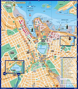
A city map is a large-scale thematic map of a city created to enable the fastest possible orientation in an urban space. The graphic representation of objects on a city map is therefore usually greatly simplified, and reduced to generally understood symbology.

Pietro Coppo was an Italian geographer and cartographer who wrote a description of the entire world as known in the 16th century, accompanied by a set of systematically arranged maps, one of the first rutters and also a precise description of the Istrian Peninsula, accompanied by its first regional map.

Antoine du Pérac Lafréry (1512–1577), better known as Antonio Lafreri, was a Burgundian engraver, cartographer and publisher active in Rome.
