Lairg

Last updated

Lairg
Village of Lairg in the Highlands.jpg
Lairg
Sutherland UK location map.svg
Red pog.svg
Lairg
Location within the Sutherland area
Population891 (2011 census)
OS grid reference NC582064
  Edinburgh 150 mi (241 km)
  London 481 mi (774 km)
Council area
Lieutenancy area
Country Scotland
Sovereign state United Kingdom
Post town LAIRG
Postcode district IV27
Dialling code 01549
Police Scotland
Fire Scottish
Ambulance Scottish
UK Parliament
Scottish Parliament
List of places
UK
Scotland
58°01′N4°24′W / 58.02°N 4.40°W / 58.02; -4.40
The village of Lairg Photograph of Lairg Scotland.jpg
The village of Lairg

Lairg (Scottish Gaelic : An Luirg, meaning "the shank/shin") [1] is a village and parish in Sutherland, Scotland. [2] It has a population of 891 [3] and is at the south-eastern end of Loch Shin.

Contents

Lairg is unusual in the northern Highlands in being a large settlement that is not on the coast. One of the reasons that Lairg is slightly bigger than other non-coastal Highland villages is its central location within the county of Sutherland. Having four roads which meet in the village, it used to be known as "The Crossroads of the North". In the 19th century, it was provided with a railway station (at NC582039 ), on what is now the Far North Line. This development means that the north-west of Sutherland is now easier to reach. (The Far North Line links Inverness in the south with Thurso and Wick in the north.)

Sheep sales

Lairg is the location of the largest single-day sheep sale in Europe. These auctions take place in August and bring people from all over Scotland to buy or sell their animals.

Gala Week

In July, Lairg holds a Gala Week. This is organised by a local committee in order to put on fun activities for adults and children. Events include fancy-dress parades, a pet show, fishing competitions on Loch Shin or the Little Loch Shin, and dances with live music in the community centre.

Lairg Crofters' Show

This one-day event has been running for 100 years. It attracts many spectators and participants for activities such as horse-jumping, sheep and cow judging, children's sports, Highland sports (e.g. tossing the caber, throwing the wellie/haggis) and homemade crafts. Sheep racing has even become a significant attraction in recent years.
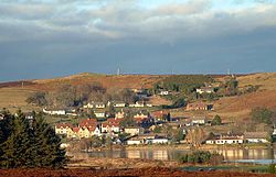
Little Loch Shin

Little Loch Shin lies directly in the centre of the village. It is a manmade loch created by the hydroelectric dam scheme, and is the home of the "Broon's hoose", a small, wooden dwelling on an islet. Loch Shin itself lies to the north of Lairg and is 17 miles (27 km) long.

Facilities

Lairg has a petrol station, pub/hotel, post office, bank, caravan site, primary school, tourist information centre, and various shops, cafes and B&Bs. Tourists attractions include the Shin Falls, fishing, sightseeing and hillwalking.

Transport

Lairg railway station lies on the picturesque Far North Line, north of Invershin and west of Rogart. It is managed by ScotRail.

A proposal on the rail routes to the north of Inverness is to create a more direct rail from Inverness to Dornoch via a new bridge and an old branch line, which would leave Lairg isolated on a circuitous loop away from the main route. Although the link would shorten journey times to Thurso and Wick, reducing the rail service to Lairg would be detrimental to the local economy. Given the huge cost of building a rail bridge over the Dornoch Firth and both the Scottish government and the Highland Regional council's lack of enthusiasm for the project, it seems unlikely the proposal will become reality. [4]

The B864 road leads south and passes through the hamlet of Achany. The parallel A836 road also runs south to Bonar Bridge, and passes through the village of Achinduich. The areas to the north and west are sparsely populated and crossed by just three single track roads.

Impact crater

Lairg is prospectively the site of the fifteenth largest impact crater on Earth, the Lairg Gravity Low which dates from 1.2 billion years ago and is 25 miles (40 km) across. [5]

Evidence for a bolide impact centered on Ullapool was published by a combined team of scientists from the University of Oxford and the University of Aberdeen, in March 2008. [6]

IV27 (Lairg) postcode area

IV27, with Lairg as its postal town, is the largest postcode area in the United Kingdom, at 1,393 square miles (3,608 km2). It covers a vast area of far north west Scotland, including Lochinver, Cape Wrath and Tongue. [7]

People associated with Lairg

See also

Related Research Articles

<span class="mw-page-title-main">Highland (council area)</span> Council area of Scotland

Highland is a council area in the Scottish Highlands and is the largest local government area in the United Kingdom. It was the 7th most populous council area in Scotland at the 2011 census. It shares borders with the council areas of Aberdeenshire, Argyll and Bute, Moray and Perth and Kinross. Their councils, and those of Angus and Stirling, also have areas of the Scottish Highlands within their administrative boundaries.

<span class="mw-page-title-main">Sutherland</span> Historic county in Scotland

Sutherland is a historic county, registration county and lieutenancy area in the Highlands of Scotland. Its county town is Dornoch. Sutherland borders Caithness and Moray Firth to the east, Ross-shire and Cromartyshire to the south and the Atlantic to the north and west. Like its southern neighbour Ross-shire, Sutherland has some of the most dramatic scenery in Europe, especially on its western fringe where the mountains meet the sea. These include high sea cliffs and very old mountains composed of Precambrian and Cambrian rocks.

<span class="mw-page-title-main">Caithness</span> Historic county in northern Scotland

Caithness is a historic county, registration county and lieutenancy area of Scotland.

<span class="mw-page-title-main">Dornoch Firth</span> Scottish firth

The Dornoch Firth is a firth on the east coast of Highland, in northern Scotland. It forms part of the boundary between Ross and Cromarty, to the south, and Sutherland, to the north. The firth is designated as a national scenic area, one of 40 such areas in Scotland. The national scenic area covers 15,782 ha in total, of which 4,240 ha is the marine area of the firth below low tide. A review of the national scenic areas by Scottish Natural Heritage in 2010 commented:

By comparison with other east coast firths the Dornoch Firth is narrow and sinuous, yet it exhibits within its compass a surprising variety of landscapes. It is enclosed by abrupt rounded granitic hills clad in heather moor and scree, their Gaelic names of cnoc, meall and creag giving the clue to their character. Their lower slopes are frequently wooded, oakwoods being a noticeable feature of the area, but with other deciduous and coniferous species represented in plantations which vary from the policy plantings of Skibo Castle to the pines of the Struie Forest.

<span class="mw-page-title-main">Loch Shin</span> Freshwater loch, reservoir in North West Scottish Highlands

Loch Shin is a loch in the Scottish North West Highlands. To the south is the small town of Lairg. The loch, the largest in Sutherland, runs from the north-west to the south-east and is 17 miles long.

<span class="mw-page-title-main">A836 road</span> A road in Sutherland, Highland, Scotland, UK

The A836 is a major road entirely within the Highland area of Scotland. It is 122 miles (196 km) long and runs from Ross and Cromarty to Caithness, with the majority of its length in Sutherland. At 58.648°N where it passes through East Mey, it is the northernmost A-class road in mainland Great Britain.

<span class="mw-page-title-main">Far North Line</span> A railway line in Scotland

The Far North Line is a rural railway line entirely within the Highland area of Scotland, extending from Inverness to Thurso and Wick. As the name suggests, it is the northernmost railway in the United Kingdom. The line is entirely single-track, with only passing loops at some intermediate stations allowing trains to pass each other. In common with other railway lines in the Highlands and northern Lowlands, it is not electrified and all trains are diesel-powered.

<span class="mw-page-title-main">Bonar Bridge</span> Human settlement in Scotland

Bonar Bridge is a village on the north bank of the Kyle of Sutherland to the west and the Dornoch Firth to the east in the Parish of Creich in the Highland council area of Scotland.

<span class="mw-page-title-main">Altnabreac railway station</span> Railway station in Highland, Scotland

Altnabreac railway station is a rural railway station in the Highland council area of Scotland. It serves the area of Altnabreac – a settlement in which the station itself is the main component – in the historic county of Caithness. The name Altnabreac derives from the Scots Gaelic Allt nam Breac, meaning "the stream of the trout".

<span class="mw-page-title-main">Golspie</span> Human settlement in Scotland

Golspie is a village and parish in Sutherland, Highland, Scotland, which lies on the North Sea coast in the shadow of Ben Bhraggie. It has a population of around 1,350.

<span class="mw-page-title-main">Invershin railway station</span> Railway station in Highland, Scotland

Invershin railway station is a railway station in the Highland council area of Scotland. The station is on the Far North Line, 61 miles 34 chains (98.9 km) from Inverness, between Culrain and Lairg. ScotRail, who manage the station, operate all services.

<span class="mw-page-title-main">Lairg railway station</span> Railway station in Highland, Scotland

Lairg railway station is a railway station just south of the village of Lairg in the Highland council area of Scotland. The station is on the Far North Line, 66 miles 78 chains (107.8 km) from Inverness, between Invershin and Rogart. ScotRail, who manage the station, operate all services.

<span class="mw-page-title-main">Georgemas Junction railway station</span> Railway station in Highland, Scotland

Georgemas Junction railway station is a railway station located in the Highland council area in the far north of Scotland. It serves several rural hamlets in the historic county of Caithness, including Georgemas, Roadside and Banniskirk. It is also the nearest station to the village of Halkirk, which lies approximately 1.6 miles (2.6 km) west of the station.

<span class="mw-page-title-main">Thurso railway station</span> Railway station in Highland, Scotland

Thurso railway station is a railway station located in Thurso, in the Highland council area in the far north of Scotland. It serves the town and its surrounding areas, along with ferry services linking the mainland with Stromness on the Orkney Islands.

<span class="mw-page-title-main">Wick railway station</span> Railway station in Highland, Scotland

Wick railway station is a railway station located in Wick, in the Highland council area in the far north of Scotland. It serves the town of Wick and other surrounding areas in the historic county of Caithness, including Staxigoe, Papigoe and Haster. The station is the terminus of the Far North Line, 161 miles 36 chains from Inverness. It is managed by ScotRail, who operate all trains serving the station.

The Sutherland Railway was a railway company authorised in 1865 to build a line from Bonar Bridge station to Brora, a distance of nearly 33 miles, in the north of Scotland. This was to be continuation of a route from Inverness to Bonar Bridge that had been built by the Inverness and Ross-shire Railway; ultimately the line was extended to Thurso.

The Inverness and Ross-shire Railway was a Scottish railway company formed in 1860 to build a line from Inverness to Invergordon. It opened in 1862 as far as Dingwall and in 1863 to Invergordon. It was extended to a Bonar Bridge station in 1864. It provided the basis for later extensions that eventually reached Thurso, forming the Far North Line. The Dingwall and Skye Railway branched off at Dingwall to reach the Kyle of Lochalsh.

<span class="mw-page-title-main">Achfrish</span> Human settlement in Scotland

Achfrish is a hamlet situated towards the southeastern part of Loch Shin on the north side of the Loch in Highland, Scotland. It is also part of the wider community of Shinness which is made up of Achfrish, Tirryside, Achnairn, Colabul, Blairbuie and West Shinness. Achfrish is on the hill overlooking Loch Shin with views of Ben More Assynt to the West and Ben Klibreck to the North. Achfrish is approximately 4 miles from the larger village of Lairg which has a selection of shops, primary school and doctor's surgery. Secondary education is catered for in the coastal towns of Golspie and Dornoch.

<span class="mw-page-title-main">Dornoch Light Railway</span> Defunct branch railway in Scotland

The Dornoch Light Railway was a branch railway in Scotland that ran from The Mound on the Far North Line to Dornoch, the county town of Sutherland.

The Far North Line was built in several stages through sparsely populated and undulating terrain. Extending to 161 miles (259 km), it runs north from Inverness to Wick and Thurso in Caithness, and currently carries a regular passenger train service.

References

  1. Gaelic and Norse in the Landscape: Placenames in Caithness and Sutherland Archived 21 September 2011 at the Wayback Machine . Scottish National Heritage.
  2. Gittings, Bruce; Munro, David. "Lairg, Highland". The Gazetteer for Scotland. School of GeoSciences, University of Edinburgh and The Royal Scottish Geographical Society. Retrieved 7 February 2019.
  3. GROS. "Standard Outputs - Census Data Explorer - Scotland's Census". www.scotlandscensus.gov.uk.
  4. "Council giving short shrift to rail, claims union". www.johnogroat-journal.co.uk. Archived from the original on 7 November 2017. Retrieved 15 September 2012.
  5. "Ancient meteorite crater mapped". 14 September 2016 via www.bbc.co.uk.
  6. "Britain's biggest meteorite impact found" (Press release). University of Aberdeen. 26 March 2008. Retrieved 22 March 2015.
  7. "All you need to know about postcodes but were afraid to ask" . Retrieved 13 August 2021.