
The Aztecs were a Mesoamerican culture that flourished in central Mexico in the post-classic period from 1300 to 1521. The Aztec people included different ethnic groups of central Mexico, particularly those groups who spoke the Nahuatl language and who dominated large parts of Mesoamerica from the 14th to the 16th centuries. Aztec culture was organized into city-states (altepetl), some of which joined to form alliances, political confederations, or empires. The Aztec Empire was a confederation of three city-states established in 1427: Tenochtitlan, city-state of the Mexica or Tenochca, Texcoco, and Tlacopan, previously part of the Tepanec empire, whose dominant power was Azcapotzalco. Although the term Aztecs is often narrowly restricted to the Mexica of Tenochtitlan, it is also broadly used to refer to Nahua polities or peoples of central Mexico in the prehispanic era, as well as the Spanish colonial era (1521–1821). The definitions of Aztec and Aztecs have long been the topic of scholarly discussion ever since German scientist Alexander von Humboldt established its common usage in the early 19th century.
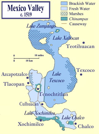
Tetzcoco was a major Acolhua altepetl (city-state) in the central Mexican plateau region of Mesoamerica during the Late Postclassic period of pre-Columbian Mesoamerican chronology. It was situated on the eastern bank of Lake Texcoco in the Valley of Mexico, to the northeast of the Aztec capital, Tenochtitlan. The site of pre-Columbian Tetzcoco is now subsumed by the modern Mexican municipio of Texcoco and its major settlement, the city formally known as Texcoco de Mora. It also lies within the greater metropolitan area of Mexico City.

Chinampa is a technique used in Mesoamerican agriculture which relies on small, rectangular areas of fertile arable land to grow crops on the shallow lake beds in the Valley of Mexico. The word chinampa has Nahuatl origins, chinampa meaning “in the fence of reeds”. They are built up on wetlands of a lake or freshwater swamp for agricultural purposes, and their proportions ensure optimal moisture retention. This method was also used and occupied most of Lake Xochimilco. The United Nations designated it a Globally Important Agricultural Heritage System in 2018.

Xochimilco is a borough of Mexico City. The borough is centered on the formerly independent city of Xochimilco, which was established on what was the southern shore of Lake Xochimilco in the precolonial period.

Tláhuac is a borough in the Mexico City, located in the southeastern edge of the entity. Though Tláhuac still contains rural communities within its borders, mostly in the southern and eastern portions, the borough has undergone a massive shift from urbanization, especially in its northwest. Tláhuac has experienced the fastest rate of population growth in Mexico City since the 1960s.

Acamapichtli was the first Tlatoani, or king, of the Aztecs of Tenochtitlan, and founder of the Aztec imperial dynasty. Chronicles differ as to the dates of his reign: according to the Codex Chimalpahin, he reigned from 1367 to 1387; according to the Codex Aubin, he reigned from 1376 to 1395; and according to the Codex Chimalpopoca, he reigned from 1350 to 1403.

Itzcoatl (1380–1440) was the fourth king of Tenochtitlan, and the founder of the Aztec Empire, ruling from 1427 to 1440. Under Itzcoatl the Mexica of Tenochtitlan threw off the domination of the Tepanecs and established the Triple Alliance together with the other city-states Tetzcoco and Tlacopan.

Lake Texcoco was a natural lake within the Anahuac or Valley of Mexico. Lake Texcoco is best known for an island situated on the western side of the lake where the Mexica built the city of Mēxihco Tenōchtitlan, which would later become the capital of the Aztec Empire. After the Spanish conquest, efforts to control flooding led to most of the lake being drained.
The Valley of Mexico, sometimes also called Basin of Mexico, is a highlands plateau in central Mexico. Surrounded by mountains and volcanoes, the Valley of Mexico was a centre for several pre-Columbian civilizations including Teotihuacan, the Toltec, and the Aztec Empire. The valley used to contain five interconnected lakes called Lake Zumpango, Lake Xaltocan, Lake Xochimilco, Lake Chalco and the largest, Lake Texcoco, covering about 1,500 square kilometers (580 sq mi) of the valley floor. When the Spaniards arrived in the Valley of Mexico, it had one of the highest population concentrations in the world with about one million people. After the conquest of the Aztec Empire, the Spaniards rebuilt the largest and most dominant city, Mēxihco Tenōchtitlan, renaming it Ciudad de México and over time began to drain the lakes' waters to control flooding.
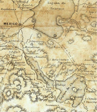
Lake Xochimilco is an ancient endorheic lake, located in the present-day Borough of Xochimilco in southern Mexico City. It is the last remaining habitat of the axolotl.
The Aztecs were a Pre-Columbian Mesoamerican people of central Mexico in the 14th, 15th, and 16th centuries. They called themselves Mēxihcah.

The Stone of Motecuhzoma I is a pre-Columbian stone monolith dating back to the rule of Motecuhzoma I (1440-1469), the fifth Tlatoani (ruler) of Tenochtitlan. The monolith measures approximately 12 feet in diameter and 39 inches tall, and is also known as the Stone of Motecuhzoma Ilhuicamina, the Cuauhxicalli of Motecuhzoma Ilhuicamina, the Archbishop's Stone, the Ex-Arzobispado Stone, and the Sánchez-Nava Monolith. Historical sources refer to it simply as "temalacatl," literally meaning "round stone."
Chalco de Díaz Covarrubias is a city that is municipal seat of the surrounding municipality of Chalco. It lies in the eastern part of the State of Mexico just east of the Federal District of Mexico and is considered part of the Mexico City metropolitan area.

The Acolhua are a Mesoamerican people who arrived in the Valley of Mexico in or around the year 1200 CE. The Acolhua were a sister culture of the Aztecs as well as the Tepanec, Chalca, Xochimilca and others.
Culhuacan was one of the Nahuatl-speaking pre-Columbian city-states of the Valley of Mexico. According to tradition, Culhuacan was founded by the Toltecs under Mixcoatl and was the first Toltec city. The Nahuatl speakers agreed that Culhuacán was the first city to give its rulers the title of "speaker" (tlatoani). In the sixteenth century following the Spanish conquest of the Aztec Empire, Culhuacan was incorporated into colonial New Spain and called a pueblo, but in local-level documentation in Nahuatl, residents continued to use the designation altepetl for their settlement.
The geography of Mesoamerica describes the geographic features of Mesoamerica, a culture area in the Americas inhabited by complex indigenous pre-Columbian cultures exhibiting a suite of shared and common cultural characteristics. Several well-known Mesoamerican cultures include the Olmec, Teotihuacan, the Maya, the Aztec and the Purépecha. Mesoamerica is often subdivided in a number of ways. One common method, albeit a broad and general classification, is to distinguish between the highlands and lowlands. Another way is to subdivide the region into sub-areas that generally correlate to either culture areas or specific physiographic regions.
Xaltocan was a pre-Columbian city-state and island in the Valley of Mexico, located in the center of Lake Xaltocan, part of an interconnected shallow lake system which included Lake Texcoco; this place is now inside the village of San Miguel Jaltocan in Nextlalpan, State of Mexico. The site was originally settled by the Otomi people but following a war in the late fourteenth century where the Otomi were defeated by an alliance of Tepanecs and Mexica the Otomi were driven off the island and relocated to Otumba, Metztitlan and Tlaxcala. The island of Xaltocan was then resettled by Nahuatl speakers. The name can mean either of two things in the Nahuatl language: either 'sandy ground of spiders' or 'where it is planted on the sand'.

The pre-Columbian history of the territory now making up the country of Mexico is known through the work of archaeologists and epigraphers, and through the accounts of Spanish conquistadores, settlers and clergymen as well as the indigenous chroniclers of the immediate post-conquest period.
Xochimilco was the most important city of the Xochimilca people, one of the Nahua tribes that migrated to the Mesoamerica region. At the same time it was the name of the altepetl of this group and historically referred to both interchangebly. The city was founded around 900 AD. It grew to become an important city in the Valley of Mexico, until in 1430, the Mexica of Tenochtitlan succeeded in conquering the city.

Lake Zumpango is an endorheic basin located in the Valley of Mexico in the municipality of Zumpango and adjacent to the municipality of Teoloyucan. Tzompanco was formerly the northernmost of five interconnected lakes, covering about 1,500 square kilometers (580 sq mi). The Valley of Mexico was a centre for several pre-Columbian civilizations including Teotihuacan, the Toltec, and the Aztec Empire. After the conquest of the Aztec Empire, the Spaniards began to drain the lakes' waters to control flooding. Over the centuries Lake Zumpango lost it its inflows and outflows and became polluted by sewage and garbage dumps. However, in recent years, the lagoon is becoming cleaner again.

