The Maumee River is a river running from northeastern Indiana into northwestern Ohio and Lake Erie in the United States. It is formed at the confluence of the St. Joseph and St. Marys rivers, where Fort Wayne, Indiana, has developed, and meanders northeastwardly for 137 miles (220 km) through an agricultural region of glacial moraines before flowing into the Maumee Bay of Lake Erie. The city of Toledo is located at the mouth of the Maumee. The Maumee was designated an Ohio State Scenic River on July 18, 1974. The Maumee watershed is Ohio’s breadbasket; it is two-thirds farmland, mostly corn and soybeans. It is the largest watershed of any of the rivers feeding the Great Lakes, and supplies five percent of Lake Erie’s water.

Lake St. Clair is a freshwater lake that lies between the Canadian province of Ontario and the U.S. state of Michigan. It was named after Clare of Assisi, on whose feast day it was navigated and christened by French Catholic explorers in 1679. It is part of the Great Lakes system, and along with the St. Clair River and Detroit River, Lake St. Clair connects Lake Huron with Lake Erie. It has a total surface area of about 430 square miles (1,100 km2) and an average depth of just 11 feet (3.4 m); to ensure an uninterrupted waterway, government agencies in both countries have maintained a deep shipping channel through the shallow lake for more than a century.
The Clinton River is a river in southeastern Michigan in the United States. It is named in honor of DeWitt Clinton, who was governor of New York from 1817 to 1823.

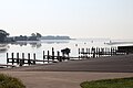
Lake St. Clair Metropark/Metro Beach Metropark is a 770-acre unit of the Huron-Clinton Metroparks system located roughly 20 miles (32 km) northeast of downtown Detroit, Michigan in Harrison Township, Macomb County. Lake St. Clair Metropark has been in existence since 1950 and has seen many changes since then. Originally named St. Clair Metropolitan Beach, it was renamed in 1953 to Metropolitan Beach Metropark and later shortened to Metro Beach Metropark. On December 8, 2011, the Board of Commissioners for the Huron-Clinton Metroparks approved changing the name to Lake St. Clair Metropark. The park is located at Jefferson Avenue and Metropolitan Parkway and there are signs to Lake St. Clair Metropark on Interstate 94 (I-94).

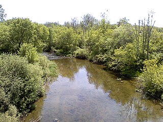
The Huron–Clinton Metroparks system is a regional park system in Metro Detroit in the U.S. state of Michigan. The park system includes 13 parks totaling more than 24,000 acres (97 km2) arranged along the Huron River and Clinton River forming a partial ring around the metro area. Plans are in development to finish the ring by building hike/bike trails to connect all the parks as a green belt. The parks draw about 9.5 million visitors a year. The rivers are prime fishing and canoeing streams with Delhi Metropark including a short rapids, which while runnable, is the only point other than dams on either stream normally portaged.
Stony Creek Metropark is a Huron-Clinton Metropark located in southeast Michigan in the outskirts of metro Detroit. The park is predominantly in Washington Township, MI and Rochester/Oakland, MI, with a small portion in Shelby Township, MI. The park covers 4,461 acres (18.05 km2) with Stony Creek Lake at its center.

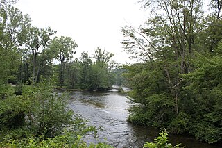
Wolcott Mill Metropark is a Huron-Clinton Metropark located in rural Ray Township, Michigan. The northern branch of the Clinton River is a fixture of the park as it bisects the entirety of the park.
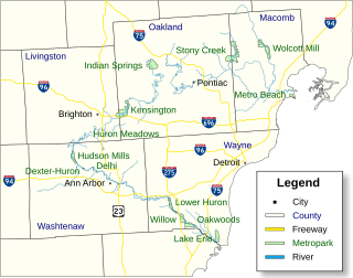
Indian Springs Metropark is a park in the Huron-Clinton system of metro parks in the US state of Michigan. The headwaters of the Huron River lie within its boundaries.

Kensington Metropark is a unit of the Huron–Clinton Metroparks system located between Milford and South Lyon, Michigan, USA. The park covers 4,543 acres (18.13 km2). It has wooded hilly terrain and surrounds 1,200-acre (4.9 km2) Kent Lake. The park has an 18-hole regulation golf course, a disc golf course, toboggan hill, a nature center, a farm learning center, picnic areas, beaches, splash pad with water slide and boat rentals. An 8-mile (13 km) paved hike-bike trail, 19 miles (31 km) of horse trails and 7 miles (11 km) of hiking-only trails are available as well as connecting trails to other nearby parks. The only camping is in organized group camping or canoe-in sites. The park receives 2.5 million visitors a year. Kensington Metropark opened in 1947.

Huron Meadows Metropark is a park in the Huron-Clinton system of metro parks. The park covers 1,576 acres (6.38 km2) along the Huron River. It has a regulation golf course, hike-bike trails and self-guided nature trails. In the winter, the park has cross-country skiing and ice-fishing.
Hudson Mills Metropark is a park in the Huron-Clinton system of metro parks in Michigan, USA. It is located on North Territorial Road at the crossing of the Huron River, twelve miles (19 km) northwest of Ann Arbor. The park covers 1,549 acres and has an 18-hole golf course, disc golf courses, picnic areas, swings and slides, softball diamonds, a hike-bike trail, nature trails, river fishing, a canoe camp and a group camp. The park is a popular destination for canoeing and kayaking; parking areas near the Huron River provide access for canoe launching. The park will eventually be linked to Dexter-Huron Metropark and Delhi Metropark via the Border-to-Border Trail. Canoe rentals are available at Delhi Metropark.
Delhi Metropark is a park in the Huron-Clinton system of metro parks. It is a 81-acre (330,000 m2) park on the Huron River located five miles (8 km) northwest of Ann Arbor. It has picnic areas, two picnic shelters, swings and slides, river fishing, canoe rental and softball diamonds. A children's playground features an adventure playship, ride-on toys and swings. A Metropark daily or annual vehicle permit is required for entry to the park. The park will eventually be linked to Dexter-Huron Metropark and Hudson Mills Metropark via the Border-to-Border Trail.

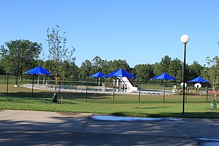
Lower Huron Metropark is a park in the Huron-Clinton system of metro parks in Metro Detroit. The park covers 1,258 acres (5.09 km2) along the Huron River and has hike-bike trails and two self-guided nature trails. In the winter, the park has ice skating ponds and cross-country skiing. The park also has a water slide amusement facility, the Turtle Cove Family Aquatic Center. There is a 27-site campground, a group campground and canoe camping in the park.
Willow Metropark is a park in the Huron-Clinton system of metro parks. The Huron River runs through the middle of the park and has an 18-hole golf course, a skatepark, a 17-acre (69,000 m2) pond, a hike-bike trail, a disc golf course, a children's play area. In the winter, the park has groomed cross country ski trails.

Dexter–Huron Metropark is a 122-acre (0.49 km2) park on the Huron River in the Huron-Clinton system of metro parks. The park has three picnic areas, a children's play area, a softball diamond, fishing, and canoe launching. A Metropark daily or annual vehicle permit is required for entry. The park will eventually be linked to Hudson Mills Metropark and Delhi Metropark via the Border-to-Border Trail.
Rockport State Recreation Area is a 4,237-acre (17.15 km2) state park located along the shore of Lake Huron in Alpena and Presque Isle counties in the state of Michigan. It is operated by the Michigan Department of Natural Resources and was established in 2012. The park contains limestone formations and an old limestone quarry. There is a deep water boat launch that can accommodate all sizes of watercraft. The park is located along the Lake Huron Flyway and is used to gauge the health of Lake Huron and its shoreline environment. Several ship wrecks can be found off-shore in the Thunder Bay National Marine Sanctuary including the Portland and the Portsmouth. The park was previously known as "The Rockport property" and is not far north of Alpena, Michigan.
Anchor Bay is a freshwater bay that lies to the North and is a part of Lake St. Clair and is located in the U.S. state of Michigan. Anchor Bay is best described as the Northern region of Lake St. Clair. It generally encompasses the waters north of a line between Point Huron and the Middle Channel of the St. Clair River. It has a total surface area of over 90 square miles (230 km2) and the depth ranges from 1 to 11 feet. Overall the bay is quite shallow for its immense size.
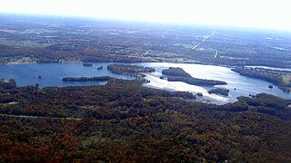
Kent Lake is a 1,200-acre reservoir lake formed by damming the Huron River near its headwaters. Kent Lake is mostly located in Oakland County, Michigan in Milford and Lyon Townships, with a small portion including its dam located in Green Oak Township, Livingston County, Michigan.