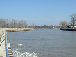
Lake Macatawa

Last updated
Lake Macatawa
Lake Macatawa 2009.jpg
Lake Macatawa in 2009
Relief map of USA Michigan.png
Red pog.svg
Lake Macatawa
Usa edcp relief location map.png
Red pog.svg
Lake Macatawa
Location Ottawa County, Michigan
Coordinates 42°46′44″N86°10′47″W / 42.7788°N 86.1798°W / 42.7788; -86.1798
Type Lake
Primary inflows Macatawa River
Primary outflows Lake Michigan
Basin  countries United States
Max. length6 mi (9.7 km)
Max. width1.2 mi (1.9 km)
Surface area2.83 sq mi (7.3 km2)
Average depth10 ft (3.0 m)
Max. depth34 ft (10 m)
Surface elevation581 ft (177 m) [1]
Islands None
Settlements Holland, Michigan
The channel connecting Lake Macatawa to Lake Michigan, facing Lake Macatawa. MacatawaChannel.jpg
The channel connecting Lake Macatawa to Lake Michigan, facing Lake Macatawa.

Lake Macatawa, historically known as Black Lake, [2] is a lake in Ottawa County in the U.S. state of Michigan.

Contents

Geography

The lake is about 6 miles (9.7 km) long with a maximum width of 1.2 miles (1.9 km) and a surface area of 1,700 acres (2.7 sq mi; 6.9 km2). The average depth of the lake is variable but generally less than 10 feet (3 m), excluding a navigation channel of fixed depth that crosses the lake to allow deep draft ships to access the dock at the City of Holland. The lake occupies portions of Park Township, Holland Township, and the City of Holland.

The lake contains two bays of significant size: Big Bay, and the smaller Pine Creek Bay to the east. The lake is the drowned river mouth of the Macatawa River (formerly known as the Black River), which feeds into the lake's eastern end in the City of Holland. Other tributaries include Pine Creek, which feeds into Pine Creek Bay, and Winstrom Creek, which feeds into Big Bay. The lake discharges into Lake Michigan at the U.S. Army Corps of Engineers channel near Holland State Park. The lake and its watershed encompass 114,560 acres (464 km2) of Ottawa and Allegan counties.

Industry

The eastern end of the lake is marked by industrial development within the City of Holland, and includes a decommissioned coal-fired power plant, scrap metal recycling facility, environmental research facility owned by Michigan State University, [3] aggregate mineral loading dock, and a pickle production facility owned by the H.J. Heinz company. The remainder of the lakeshore is marked by high-income residential development, with the notable exception of Holland State Park which borders the northern shoreline of the western end of the lake, Howard B. Dunton park on the north shore of the eastern end, and Kollen Park near the Heinz factory, which connects to a boardwalk installed along the shoreline occupied by the facility.

See also

Related Research Articles

<span class="mw-page-title-main">Jackson County, Michigan</span> County in Michigan, United States

Jackson County is a county located in the U.S. state of Michigan. Its population was 160,366 as of the 2020 Census. The county seat is Jackson. The county was set off in 1829 and organized in 1832. It is named for U.S. President Andrew Jackson and considered to be one of Michigan's "Cabinet counties", named for members of Jackson's Cabinet.

<span class="mw-page-title-main">Ottawa County, Michigan</span> County in Michigan, United States

Ottawa County is a county located in the U.S. state of Michigan. As of the United States 2020 Census, the population was 296,200. The county seat is Grand Haven. The county is named for the Ottawa Nation, was set off in 1831 and organized in 1837. Ottawa County is included in the Grand Rapids-Kentwood, MI Metropolitan Statistical Area and has a significant Dutch American population.

<span class="mw-page-title-main">Ontonagon County, Michigan</span> County in Michigan, United States

Ontonagon County is a county in the Upper Peninsula of the U.S. state of Michigan. As of the 2020 census, the population was 5,816, making it Michigan's third-least populous county. The county seat is Ontonagon. The county was set off in 1843, and organized in 1848. Its territory had been organized as part of Chippewa and Mackinac counties. With increasing population in the area, more counties were organized. After Ontonagon was organized, it was split to create Gogebic County. It is also the westernmost county in United States that lies within the Eastern Time Zone.

<span class="mw-page-title-main">Iosco County, Michigan</span> County in Michigan, United States

Iosco County is a county in the U.S. state of Michigan; its eastern border is formed by Lake Huron. As of the 2020 census, the population was 25,237. The county seat is Tawas City.

<span class="mw-page-title-main">Emmet County, Michigan</span> County in Michigan, United States

Emmet County is a county located in the U.S. state of Michigan. It is the northernmost county in the Lower Peninsula. As of the 2020 Census, the population was 34,112, making it the second-most populous county in Northern Michigan. The county seat is Petoskey, which is also the county's largest city.

<span class="mw-page-title-main">Allegan County, Michigan</span> County in Michigan, United States

Allegan County is a county in the U.S. state of Michigan. As of the 2020 United States Census, the population was 120,502. The county seat is Allegan. The name was coined by Henry Rowe Schoolcraft to sound like a Native American word.

<span class="mw-page-title-main">East Bay Township, Michigan</span> Charter township in Michigan, United States

East Bay Charter Township is a charter township of Grand Traverse County in the U.S. state of Michigan. The population was 11,589 at the 2020 census, up from 10,663 at the 2010 census. It is one of three charter townships in Grand Traverse County, the others being Long Lake Township and neighboring Garfield Township. East Bay Township is the second-most populous township in Northern Michigan, behind Garfield Township.

Park Township is a civil township of Ottawa County in the U.S. state of Michigan. As of the 2020 census, the township population was 18,625.

<span class="mw-page-title-main">Holland, Michigan</span> City in Michigan, United States

Holland is a city in the western region of the Lower Peninsula of the U.S. state of Michigan. It is situated near the eastern shore of Lake Michigan on Lake Macatawa, which is fed by the Macatawa River. Holland is a thriving city with a diverse economy that includes manufacturing, agriculture, tourism, and higher education. It is home to a number of prominent companies, including Herman Miller, Haworth, and Johnson Controls. The city also attracts thousands of visitors each year for its annual Tulip Time Festival, which celebrates the area's Dutch heritage and vibrant tulip fields.

<span class="mw-page-title-main">Lake St. Clair</span> Lake bordering Ontario, Canada and Michigan, US

Lake St. Clair is a freshwater lake that lies between the Canadian province of Ontario and the U.S. state of Michigan. It was named in 1679 by French Catholic explorers after Saint Clare of Assisi, on whose feast day they first saw the lake.

The Thumb is a region and a peninsula of the U.S. state of Michigan, so named because the Lower Peninsula is shaped like a mitten. The Thumb area is generally considered to be in the Central Michigan region, east of the Tri-Cities and north of Metro Detroit. The region is also branded as the Blue Water Area.

<span class="mw-page-title-main">Lake Charlevoix</span> Lake in the state of Michigan, United States

Lake Charlevoix is a lake in Charlevoix County in the U.S. state of Michigan. It is the third largest inland lake in the state with a surface area of over 17,200 acres (70 km2) and 56 miles (90 km) of shoreline. The maximum depth in the main basin is 122 feet (37 m) and in the south arm, 58 feet (18 m).

<span class="mw-page-title-main">Toronto Harbour</span> Bay on the north shore of Lake Ontario, in Toronto, Ontario, Canada

Toronto Harbour or Toronto Bay is a bay on the north shore of Lake Ontario, in Toronto, Ontario, Canada. It is a natural harbour, protected from Lake Ontario waves by the Toronto Islands. Today, the harbour is used primarily for recreational boating, including personal vessels and pleasure boats providing scenic or party cruises. Ferries travel from docks on the mainland to the Islands, and cargo ships deliver aggregates and raw sugar to industries located in the harbour. Historically, the harbour has been used for military vessels, passenger traffic and cargo traffic. Waterfront uses include residential, recreational, cultural, commercial and industrial sites.

<span class="mw-page-title-main">Holland State Park</span> Park in Michigan, USA

Holland State Park is a public recreation area covering 142 acres (57 ha) in Park Township, Ottawa County, four miles (6 km) west of the city of Holland, Michigan. The state park consists of separate Lake Macatawa and Lake Michigan units on the northern side of the channel connecting Lake Macatawa with Lake Michigan. It is often the most visited state park in Michigan, receiving between 1.5 and 2 million visitors annually.

<span class="mw-page-title-main">Muskegon Lake</span> Lake in Muskegon County, Michigan

Muskegon Lake is a 4,150-acre (16.8 km2) fresh-water lake in Muskegon County, Michigan, USA. Located in the lower peninsula at the mouth of the Muskegon River, Muskegon Lake forms a 12-square-mile (31 km2) broad harbor along the eastern shoreline of Lake Michigan, approximately 2.5 miles (4.0 km) wide by 5.5 miles (8.9 km) long.

William W. Powers State Recreation Area is an Illinois state park administered by the Illinois Department of Natural Resources on 580 acres (230 ha) in the Hegewisch community area of the City of Chicago in Cook County, Illinois, United States. The area includes 419 acres (170 ha) of water in Wolf Lake that provides about 6 miles (10 km) of shoreline to fishermen. The park hosts about half a million visitors annually. The park contains numerous species, and is one of the most important biological sites in the Chicago region.

<span class="mw-page-title-main">Macatawa River</span> River in Michigan, United States

The Macatawa River, also known as the Black River, is located in the lower part of Ottawa County, Michigan, which drains into Lake Macatawa and eventually into Lake Michigan. The main stream is 16.8 miles (27.0 km) long.

<span class="mw-page-title-main">Water and Woods Field Service Council</span>

Water and Woods Field Service Council was a field service council of the Michigan Crossroads Council that served youth in the central and northeastern Lower Peninsula of Michigan. The Council was headquartered in Flint, Michigan, with service centers located in Auburn, Lansing, and Port Huron. The Water and Woods Field Service Council was the result of a merger in 2012 of Lake Huron Area Council, Blue Water Council, Tall Pine Council and Chief Okemos Council.

<span class="mw-page-title-main">Ottawa Beach Historic District</span> Historic district in Michigan, United States

The Ottawa Beach Historic District is a residential historic district located on Ottawa Beach Road in Park Township, Ottawa County, Michigan near the outlet of Lake Macatawa. It was listed on the National Register of Historic Places in 1995.

References