

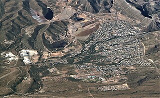
Lake Valley was a silver-mining town in Sierra County, U.S. state of New Mexico.
Contents
The 'heyday' of the town was from 1881 to 1893. The last resident departed in 1994.
The present day ghost town is deserted.
Lake Valley was a silver-mining town in Sierra County, U.S. state of New Mexico.
The 'heyday' of the town was from 1881 to 1893. The last resident departed in 1994.
The present day ghost town is deserted.
The townsite of Lake Valley is partly privately owned, and partly owned by the U.S. Bureau of Land Management, which has restricted access to the old buildings to daylight hours, to prevent vandalism. There is a self-guided walking tour for visitors. The town is closed to the public on Tuesdays and Wednesdays.

A rancher found the Lake Valley silver deposits in Sierra County in 1876. Two years later he sold his claims to an engineer, who began mining. [1] The deposits are bedded manto -type deposits in Paleozoic limestone. The mines produced well for a few years after miners tunneled into a silver-lined cavity they named the "bridal chamber" that alone yielded 2.5 million troy ounces (78 tonnes) of silver.
In 1881 the property was sold to mine promoters George D. Roberts and Whitaker Wright, who split the property among five companies: Sierra Apache Co., Sierra Bella Co., Sierra Grande Co., Sierra Madre Co., and the Sierra Plata Co., and stock was sold widely in the east. Despite the brief wealth of the bridal chamber, shareholders in all five companies lost money.
In 1881, a party of Lake Valley miners formed a posse to pursue a band of Apaches that had raided the town of Hillsboro. The Apaches caught them in an ambush. The bridal chamber was worked out by 1883. Although a railroad line reached Lake Valley in 1884, the mines struggled and were worked only periodically into the 20th century. Total production of the Lake Valley district through 1931 was 5.8 million ounces (180 tonnes) of silver. [2] The mines reopened during World War II to produce manganese, and continued operating into the 1950s. Lake Valley had a post office from 1882 until 1955.
The townsite is along NM 27, 17 miles (27 km) south of Hillsboro, and 36 miles (58 km) west of Hatch, at 32°43′04″N107°34′04″W / 32.71778°N 107.56778°W . It is at an elevation of 5,377 feet (1,639 m) in Sierra County.
Lake Valley is located in a structurally elevated fault block underlain mainly by Ordovician through Pennsylvanian sedimentary rocks; ore deposits are stratabound and confined to Lower Mississippian Lake Valley Limestone carbonate rocks. The Lake Valley and Berrenda faults are the major structural features in the area. [3]
Superior is a town in Pinal County, Arizona, United States. Superior, which is in northern Pinal County, is the oldest town in that county. According to the 2020 census, the population of the town was 2,407. Superior was founded as a mining town for the Silver King and the later Magma mines; silver was mined at first, and then transitioned to copper. Currently, exploitation of the huge Resolution Copper deposit is being explored.

The Chino Mine, also known as the Santa Rita mine, also known as Santa Rita del Cobre, is an open-pit porphyry copper mine located in the town of Santa Rita, New Mexico 15 miles (24 km) east of Silver City. The mine was started as the Chino Copper Company in 1909 by mining engineer John M. Sully and Spencer Penrose, and is currently owned and operated by Freeport-McMoRan Inc. subsidiaries. The area where the mine is located is at an average elevation of 5,699 feet (1,737 m).

Hillsboro is an unincorporated community in Sierra County, New Mexico, United States, located in the southwestern part of the state. It was founded in 1877, following the discovery of gold. The community was the county seat of Sierra County from 1884 until 1936, when Hot Springs became the county seat.
The Discovery Mine was a gold mine 84 kilometers northeast of Yellowknife, Northwest Territories that operated between 1950 and 1969. Gold was discovered here by Alfred Giauque in 1944. A complete townsite, on Giauque Lake, was established by the company to house workers and their families. The mine produced one million troy ounces (31,000 kg) of gold from one million tons of ore. The abandoned townsite, not accessible by road, was demolished in 2005.

Gilman is an abandoned mining town in southeastern Eagle County, Colorado, United States. The U.S. Post Office at Minturn now serves Gilman postal addresses.

Chlorargyrite is the mineral form of silver chloride (AgCl). Chlorargyrite occurs as a secondary mineral phase in the oxidation of silver mineral deposits. It crystallizes in the isometric - hexoctahedral crystal class. Typically massive to columnar in occurrence it also has been found as colorless to variably yellow cubic crystals. The color changes to brown or purple on exposure to light. It is quite soft with a Mohs hardness of 1 to 2 and dense with a specific gravity of 5.55. It is also known as cerargyrite and, when weathered by desert air, as horn silver. Bromian chlorargyrite is also common. Chlorargyrite is water-insoluble.
Harry Pye was a prospector and sometime mule skinner in New Mexico Territory who discovered silver chloride in the Black Range in 1879 initiating a multimillion-dollar silver rush.
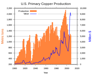
In the United States, copper mining has been a major industry since the rise of the northern Michigan copper district in the 1840s. In 2017, the US produced 1.27 million metric tonnes of copper, worth $8 billion, making it the world's fourth largest copper producer, after Chile, China, and Peru. Copper was produced from 23 mines in the US. Top copper producing states in 2014 were Arizona, Utah, New Mexico, Nevada, and Montana. Minor production also came from Idaho, and Missouri. As of 2014, the US had 45 million tonnes of known remaining reserves of copper, the fifth largest known copper reserves in the world, after Chile, Australia, Peru, and Mexico.

In the United States, gold mining has taken place continually since the discovery of gold at the Reed farm in North Carolina in 1799. The first documented occurrence of gold was in Virginia in 1782. Some minor gold production took place in North Carolina as early as 1793, but created no excitement. The discovery on the Reed farm in 1799 which was identified as gold in 1802 and subsequently mined marked the first commercial production.
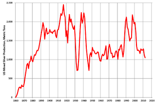
Silver mining in the United States began on a major scale with the discovery of the Comstock Lode in Nevada in 1858. The industry suffered greatly from the demonetization of silver in 1873 by the Coinage Act of 1873, known pejoratively as the "Crime of 73", but silver mining continues today.
Silver mining in Arizona was a powerful stimulus for exploration and prospecting in early Arizona. Cumulative silver production through 1981 totaled 490 million troy ounces. However, only about 10% of Arizona's silver production came from silver mining. More than 80% of the state's silver was a byproduct of copper mining; other silver came as a byproduct of lead, zinc, and gold mining.

Shafter is a ghost town in Presidio County, Texas. The Texas Attorney General's Office gives a population of 11 as of the 2000 Census. It was named in honor of General William R. Shafter, who at one point commanded the nearby Fort Davis. As of 2012, at least one silver mine, La Mina Grande, has been reopened by Aurcana Corporation.

Harshaw is a ghost town in Santa Cruz County in the southeastern part of the U.S. state of Arizona. The town was settled in the 1870s, in what was then Arizona Territory. Founded as a mining community, Harshaw is named after the cattleman-turned-prospector David Tecumseh Harshaw, who first successfully located silver in the area. At the town's peak near the end of the 19th century, Harshaw's mines were among Arizona's highest producers of ore, with the largest mine, the Hermosa, yielding approximately $365,455 in bullion over a four-month period in 1880.
Golden is a ghost town in Box Elder County, Utah, United States. It is located 6 miles (9.7 km) west of Park Valley, near the southern base of the Raft River Mountains.
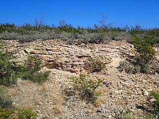
The Lake Valley Limestone is a geologic formation widely exposed in southwestern New Mexico. It preserves fossils dating back to the lower to middle Mississippian.

Kingston is a census-designated place (CDP) in Sierra County, New Mexico, United States. Its population was 32 as of the 2010 census. The community is located in the Black Range along New Mexico State Road 152.

Salero is a ghost town in the Santa Rita Mountains of Santa Cruz County, Arizona. As one of the best preserved ghost towns remaining in Arizona, Salero is located on private property of the Salero Ranch and is not open to visitors.
New Mexico State Road 27 (NM 27) is a 30.200-mile-long (48.602 km) paved, two-lane state highway in Sierra and Luna counties in the U.S. state of New Mexico. It travels south-to-north over the eastern flank of the Black Range.
Municipalities and communities of Sierra County, New Mexico, United States | ||
|---|---|---|
| Cities | 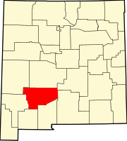 | |
| Villages | ||
| CDPs | ||
| Other communities | ||
| Ghost towns | ||
| International | |
|---|---|
| National | |