A cave or cavern is a natural void in the ground, specifically a space large enough for a human to enter. Caves often form by the weathering of rock and often extend deep underground. The word cave can refer to smaller openings such as sea caves, rock shelters, and grottos, that extend a relatively short distance into the rock and they are called exogene caves. Caves which extend further underground than the opening is wide are called endogene caves.

A sinkhole is a depression or hole in the ground caused by some form of collapse of the surface layer. The term is sometimes used to refer to doline, enclosed depressions that are locally also known as vrtače and shakeholes, and to openings where surface water enters into underground passages known as ponor, swallow hole or swallet. A cenote is a type of sinkhole that exposes groundwater underneath. Sink and stream sink are more general terms for sites that drain surface water, possibly by infiltration into sediment or crumbled rock.
An underwater environment is a environment of, and immersed in, liquid water in a natural or artificial feature, such as an ocean, sea, lake, pond, reservoir, river, canal, or aquifer. Some characteristics of the underwater environment are universal, but many depend on the local situation.

A spring is a natural exit point at which groundwater emerges out of the aquifer and flows onto the top of the Earth's crust (pedosphere) to become surface water. It is a component of the hydrosphere, as well as a part of the water cycle. Springs have long been important for humans as a source of fresh water, especially in arid regions which have relatively little annual rainfall.
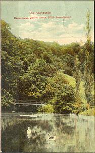
The Aachtopf is Germany's biggest karst spring, south of the western end of the Swabian Jura near the town of Aach. It produces an average of 8,500 litres per second. Most of the water stems from the River Danube where it disappears underground at the Danube Sinkhole, 12 kilometres (7.5 mi) north near Immendingen and about 14 kilometres (8.7 mi) north near Fridingen. The cave system has been explored since the 1960s, but as of 2020 only a small part has been discovered due to a large blockage after a few hundred metres.
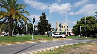
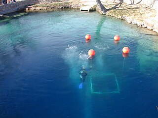
Vouliagmeni is a seaside suburb and former municipality 20 km south of Athens city centre. Since the 2011 local government reform it is part of the municipality Vari-Voula-Vouliagmeni, of which it is a municipal unit. The municipal unit has an area of 5.805 km2. Its population was 4,180 at the 2011 census. In 1993 and again in 2009, it hosted the annual meeting of the Bilderberg Group. The suburb is named after Lake Vouliagmeni, located in its vicinity. It is one of the most prestigious Athenian suburbs, home to renowned hotels and beaches. The area has some of the highest real estate prices in the Balkans.

The olm or proteus is an aquatic salamander which is the only species in the genus Proteus of the family Proteidae and the only exclusively cave-dwelling chordate species found in Europe; the family's other extant genus is Necturus. In contrast to most amphibians, it is entirely aquatic, eating, sleeping, and breeding underwater. Living in caves found in the Dinaric Alps, it is endemic to the waters that flow underground through the extensive limestone bedrock of the karst of Central and Southeastern Europe in the basin of the Soča River near Trieste, Italy, southwestern Croatia, and Bosnia and Herzegovina. Introduced populations are found near Vicenza, Italy, and Kranj, Slovenia. It was first mentioned in 1689 by the local naturalist Valvasor in his Glory of the Duchy of Carniola, who reported that, after heavy rains, the olms were washed up from the underground waters and were believed by local people to be a cave dragon's offspring.

A cenote is a natural pit, or sinkhole, resulting from the collapse of limestone bedrock that exposes groundwater. The regional term is specifically associated with the Yucatán Peninsula of Mexico, where cenotes were commonly used for water supplies by the ancient Maya, and occasionally for sacrificial offerings. The term derives from a word used by the lowland Yucatec Maya—tsʼonoʼot—to refer to any location with accessible groundwater.
In oceanography, a halocline is a cline, a subtype of chemocline caused by a strong, vertical salinity gradient within a body of water. Because salinity affects the density of seawater, it can play a role in its vertical stratification. Increasing salinity by one kg/m3 results in an increase of seawater density of around 0.7 kg/m3.

Lake Cerknica is an intermittent lake in the southern part of the Cerknica Polje, a karst polje in Inner Carniola, a region in southwestern Slovenia. The lake, oriented in the Dinaric direction from northwest to southeast, is present for the most part of the year. When full, it is the largest lake in the country. The plain is surrounded by the Javornik Hills to the south and Slivnica to the north, both belonging to Dinaric Alps. The area of the lake mainly reaches 28 square kilometres (11 sq mi), but can reach up to 38 km2 (15 sq mi) and the surface level varies from 546 m (1,791 ft) to 551 m (1,808 ft) above sea level. The lake is an important wildlife resort, especially as a nesting place for many bird species. Botanically, it is distinguished by amphibious plants. It is therefore a part of two Natura 2000 areas of protection and the focus of the Inner Carniola Regional Park, which covers additional Natura 2000 areas in the broader region. The climate in the area is continental, with a mean temperature of 9.2 °C (48.6 °F) and the annual precipitation about 1,700 millimetres (67 in). The largest settlement at the border of the lake is Cerknica, located north of the lake. Various watersports, including rowing, are popular on the lake.

Craighead Caverns is an extensive cave system located in between Sweetwater and Madisonville, Tennessee. It is best known for containing the United States' largest and the world's second largest non-subglacial underground lake, The Lost Sea. In addition to the lake, the caverns contain an abundance of crystal clusters called anthodites, stalactites, stalagmites, and a waterfall.

Dos Ojos is part of a flooded cave system located north of Tulum, on the Caribbean coast of the Yucatán Peninsula, in the state of Quintana Roo, Mexico. The exploration of Dos Ojos began in 1987 and still continues. The surveyed extent of the cave system is 82 kilometers (51 mi) and there are 28 known sinkhole entrances, which are locally called cenotes. In January 2018, a connection was found between Sistema Dos Ojos and Sistema Sac Actun. The smaller Dos Ojos became a part of Sac Actun, making the Sistema Sac Actun the longest known underwater cave system in the world.

Devils Hole is a geologic formation located in a detached unit of Death Valley National Park and surrounded by the Ash Meadows National Wildlife Refuge, in Nye County, Nevada, in the Southwestern United States.
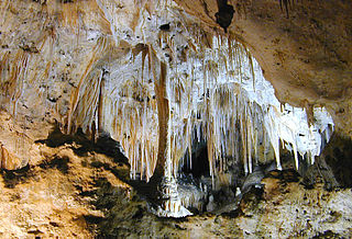
Carlsbad Caverns National Park is an American national park in the Guadalupe Mountains of southeastern New Mexico. The primary attraction of the park is the show cave Carlsbad Cavern. Visitors to the cave can hike in on their own via the natural entrance or take an elevator from the visitor center.

An underground lake or subterranean lake is a lake underneath the surface of the Earth. Most naturally occurring underground lakes are found in areas of Karst topography, where limestone or other soluble rock has been weathered away, leaving a cave where water can flow and accumulate.
The Blue Hole of Santa Rosa, or simply the Blue Hole, is a circular, bell-shaped pool or small lake located along Route 66 east of Santa Rosa, New Mexico that is a tourist attraction and swimming venue, and one of the most popular dive destinations in the US for scuba diving and training. The Blue Hole is an artesian well and cenote that was once used as a fish hatchery.

Recreational dive sites are specific places that recreational scuba divers go to enjoy the underwater environment or for training purposes. They include technical diving sites beyond the range generally accepted for recreational diving. In this context all diving done for recreational purposes is included. Professional diving tends to be done where the job is, and with the exception of diver training and leading groups of recreational divers, does not generally occur at specific sites chosen for their easy access, pleasant conditions or interesting features.
Little Blue Lake is a water-filled doline in the Australian state of South Australia located in the state's south-east in the locality of Mount Schank about 20 kilometres (12 mi) south of the municipal seat of Mount Gambier. It is notable locally as a swimming hole and nationally as a cave diving site. It is managed by the District Council of Grant and has been developed as a recreational and tourism venue.

Cave diving is underwater diving in water-filled caves. The equipment used varies depending on the circumstances, and ranges from breath hold to surface supplied, but almost all cave diving is done using scuba equipment, often in specialised configurations with redundancies such as sidemount or backmounted twinset. Recreational cave diving is generally considered to be a type of technical diving due to the lack of a free surface during large parts of the dive, and often involves planned decompression stops. A distinction is made by recreational diver training agencies between cave diving and cavern diving, where cavern diving is deemed to be diving in those parts of a cave where the exit to open water can be seen by natural light. An arbitrary distance limit to the open water surface may also be specified. Despite the risks, water-filled caves attract scuba divers, cavers, and speleologists due to their often unexplored nature, and present divers with a technical diving challenge.