
Coorong National Park is a protected area located in South Australia about 156 kilometres (97 mi) south-east of Adelaide, that predominantly covers a coastal lagoon ecosystem officially known as The Coorong and the Younghusband Peninsula on the Coorong's southern side. The western end of the Coorong lagoon is at the Murray Mouth near Hindmarsh Island and the Sir Richard Peninsula, and it extends about 130 kilometres (81 mi) south-eastwards. Road access is from Meningie. The beach on the coastal side of the peninsula, the longest in Australia, is also commonly called The Coorong.

Blue Lake National Park was a former protected area in Queensland, Australia, located on North Stradbroke Island about 44 kilometres (27 mi) east of Brisbane. Blue Lake National Park is now a part of the Naree Budjong Djara National Park. Access was provided by road 9 kilometres (5.6 mi) west of Dunwich.
Currawinya is a national park near Hungerford in South West Queensland, Australia, 828 km west of Brisbane. Part of the mulga lands bioregion this is an area of dry sandy plain with small trees and shrubs. The Paroo River passes through the park.

Great Sandy National Park is a coastal national park in the Fraser Coast Region, Queensland, Australia.

Lake Winnipeg is an extremely large, relatively shallow 24,514-square-kilometre (9,465 sq mi) lake in North America, in the province of Manitoba, Canada. Its southern end is about 55 kilometres (34 mi) north of the city of Winnipeg. Lake Winnipeg is Canada's sixth-largest freshwater lake and the third-largest freshwater lake contained entirely within Canada, but it is relatively shallow excluding a narrow 36 m (118 ft) deep channel between the northern and southern basins. It is the eleventh-largest freshwater lake on Earth. The lake's east side has pristine boreal forests and rivers that were in 2018 inscribed as Pimachiowin Aki, a UNESCO World Heritage Site. The lake is 416 km (258 mi) from north to south, with remote sandy beaches, large limestone cliffs, and many bat caves in some areas. Manitoba Hydro uses the lake as one of the largest reservoirs in the world. There are many islands, most of them undeveloped.

Fraser Island, officially K'gari, is a World Heritage-listed sand island along the south-eastern coast in the Wide Bay–Burnett region, Queensland, Australia. The island is approximately 250 km (160 mi) north of the state capital, Brisbane, and is within the Fraser Coast Region local government area. The world heritage listing includes the island, its surrounding waters and parts of the nearby mainland which make up the Great Sandy National Park

The barramundi, Asian sea bass, or giant sea perch, or dangri is a species of catadromous fish in the family Latidae of the order Perciformes. The species is widely distributed in the Indo-West Pacific, spanning the waters of the Middle East, South Asia, Southeast Asia, East Asia, and Oceania.

Lake Alexandrina is a coastal freshwater lake located between the Fleurieu and Kangaroo Island and Murray and Mallee regions of South Australia, about 100 kilometres (62 mi) south-east of Adelaide. The lake adjoins the smaller Lake Albert and a coastal lagoon called The Coorong to its southeast, before draining into the Great Australian Bight via a short, narrow opening known as Murray Mouth.

North Stradbroke Island, colloquially Straddie or North Straddie, is an island that lies within Moreton Bay in the Australian state of Queensland, 30 kilometres (19 mi) southeast of the centre of Brisbane. Originally there was only one Stradbroke Island but in 1896 it split into North Stradbroke Island and South Stradbroke Island separated by the Jumpinpin Channel. The Quandamooka people are the traditional owners of North Stradbroke island.

The Barron River is located on the Atherton Tablelands inland from Cairns in North Queensland, Australia. With its headwaters below Mount Hypipamee, the 165-kilometre (103 mi)-long river with a catchment area of approximately 2,138 square kilometres (825 sq mi) forms through run off from the Mount Hypipamee National Park, flows through Lake Tinaroo, and eventually empties into the Coral Sea near CairnsCBD and Machans Beach.

The Great Sandy Strait is a strait in the Australian state of Queensland of 70 kilometres (43 mi) length which separates mainland Queensland from Fraser Island. It is also a locality in the Fraser Coast Region local government area. In the 2021 census, Great Sandy Strait had a population too low to be reported.

Brown Lake (Bummeria) is a perched lake on North Stradbroke Island, in South-East Queensland, Australia. The ecosystem is an example of a coastal non-floodplain sand lake and is characterised by acidic water, nutrient-poor and sandy soil, shrub-like vegetation and wet heathland.
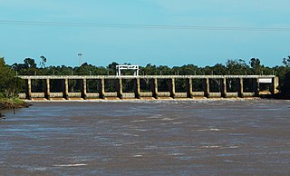
The Fitzroy River Barrage is a mid-river dam system constructed on the Fitzroy River in Rockhampton, Queensland, Australia which separates the tidal river into saltwater and freshwater sections. It was designed to dam the river, enabling a permanent water supply to be stored for the city and its surrounding communities as well as providing an agricultural water supply for registered rural users.

The K'gari Great Walk is a long-distance walking track on K'gari, Queensland, Australia. Hikers should be fully self-sufficient and to carry sufficient water. The walk is rated easy to moderate on a difficulty scale being mostly at sea level and is traversed in one direction.

The Paroo-Darling National Park is a protected national park that is located in the Far West region of New South Wales, in eastern Australia. The 178,053-hectare (439,980-acre) national park spans two distinct regions in the outback area. This region covers the arid catchments of the Paroo River and the Paroo-Darling confluence to the south.

Sandy Cape is the most northern point on Fraser Island off the coast of Queensland, Australia. The place was named Sandy Cape for its appearance by James Cook during his 1770 voyage up the eastern coast of Australia aboard the Endeavour. To the south the next two ocean headlands are Waddy Point and Indian Head.

Lake McKenzie (Boorangoora) is a perched lake on K'gari or Fraser Island in Queensland, Australia. The lake is located in the Great Sandy National Park.
The Butchulla, also written Butchella, Badjala, Badjula, Badjela, Bajellah, Badtjala and Budjilla, are an Aboriginal Australian people of K'gari, Queensland, and a small area of the nearby mainland of southern Queensland.

Happy Valley is a coastal town in the locality of K'gari in the Fraser Coast Region, Queensland, Australia.
Lake Boomanjin is a large perched lake in the Fraser Coast Region of Queensland, Australia. The lake is located on Fraser Island in the Great Sandy National Park.

