Lakefield, Minnesota

Last updated

Lakefield
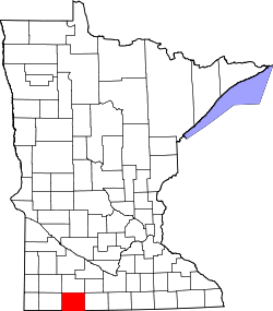
Jackson County Minnesota Incorporated and Unincorporated areas Lakefield Highlighted.svg
Location of Lakefield, Minnesota
Coordinates: 43°40′41″N95°10′10″W / 43.67806°N 95.16944°W / 43.67806; -95.16944
Country United States
State Minnesota
County Jackson
Government
  TypeMayor Council
  MayorDouglas Busch
Area
[1]
  Total1.34 sq mi (3.47 km2)
  Land1.34 sq mi (3.47 km2)
  Water0.00 sq mi (0.00 km2)
Elevation
[2]
1,480 ft (450 m)
Population
 (2020)
  Total1,735
  Density1,296.71/sq mi (500.60/km2)
Time zone UTC-6 (Central (CST))
  Summer (DST) UTC-5 (CDT)
ZIP code
56150
Area code 507
FIPS code 27-34316 [3]
GNIS feature ID2395608 [2]
Website http://www.lakefieldmn.com/

Lakefield is a city in Jackson County, Minnesota, United States. The population was 1,694 at the 2010 census. [4]

Contents

History

Lakefield was laid out in 1879, when the railroad was extended to that point. [5] It was named for its location near Heron Lake. [5] A post office has been in operation at Lakefield since 1880. [6] The city was incorporated in 1887. [5]

Geography

According to the United States Census Bureau, the city has a total area of 1.28 square miles (3.32 km2), all land. [7]

Minnesota State Highway 86 is the main route through the city. Exit 64 of Interstate 90 is about two miles south.

Demographics

Historical population
CensusPop.Note
1890 275
1900 862213.5%
1910 9247.2%
1920 1,34645.7%
1930 1,3490.2%
1940 1,69925.9%
1950 1,651−2.8%
1960 1,7898.4%
1970 1,8201.7%
1980 1,8451.4%
1990 1,679−9.0%
2000 1,7212.5%
2010 1,694−1.6%
2020 1,7352.4%
U.S. Decennial Census

2010 census

As of the census [8] of 2010, there were 1,694 people, 762 households, and 462 families living in the city. The population density was 1,323.4 inhabitants per square mile (511.0/km2). There were 838 housing units at an average density of 654.7 per square mile (252.8/km2). The racial makeup of the city was 98.0% White, 0.8% African American, 0.1% Asian, 0.7% from other races, and 0.4% from two or more races. Hispanic or Latino of any race were 2.2% of the population.

There were 762 households, of which 27.4% had children under the age of 18 living with them, 46.5% were married couples living together, 10.2% had a female householder with no husband present, 3.9% had a male householder with no wife present, and 39.4% were non-families. 35.8% of all households were made up of individuals, and 19.9% had someone living alone who was 65 years of age or older. The average household size was 2.18 and the average family size was 2.80.

The median age in the city was 41.4 years. 22.4% of residents were under the age of 18; 7.6% were between the ages of 18 and 24; 23.7% were from 25 to 44; 24.3% were from 45 to 64; and 22.1% were 65 years of age or older. The gender makeup of the city was 46.4% male and 53.6% female.

2000 census

As of the census [3] of 2000, there were 1,721 people, 731 households, and 453 families living in the city. The population density was 1,611.0 inhabitants per square mile (622.0/km2). There were 784 housing units at an average density of 733.9 per square mile (283.4/km2). The racial makeup of the city was 99.07% White, 0.23% Native American, 0.17% Asian, 0.41% from other races, and 0.12% from two or more races. Hispanic or Latino of any race were 0.93% of the population.

There were 731 households, out of which 28.0% had children under the age of 18 living with them, 53.4% were married couples living together, 6.4% had a female householder with no husband present, and 37.9% were non-families. 34.1% of all households were made up of individuals, and 20.8% had someone living alone who was 65 years of age or older. The average household size was 2.24 and the average family size was 2.88.

In the city, the population was spread out, with 23.0% under the age of 18, 6.0% from 18 to 24, 23.8% from 25 to 44, 21.4% from 45 to 64, and 25.8% who were 65 years of age or older. The median age was 43 years. For every 100 females, there were 88.5 males. For every 100 females age 18 and over, there were 81.5 males.

The median income for a household in the city was $31,250, and the median income for a family was $37,898. Males had a median income of $26,875 versus $19,932 for females. The per capita income for the city was $16,003.

Politics

Lakefield is located in Minnesota's 1st congressional district, represented by Republican Jim Hagedorn. At the state level, Lakefield is located in Senate District 22, represented by Republican Bill Weber (politician), and in House District 22B, represented by Republican Rod Hamilton.

Related Research Articles

<span class="mw-page-title-main">Sylvan Lake, Michigan</span> City in Michigan, United States

Sylvan Lake is a city in Oakland County in the U.S. state of Michigan. A northern suburb of Detroit, Sylvan Lake is located roughly 26 miles (41.8 km) from downtown Detroit, and borders Pontiac to the east. As of the 2010 census, the city had a population of 1,720. With a land area of 0.51 square miles (1.32 km2), Sylvan Lake is the fourth-smallest city by land area in the state after Clarkston, Petersburg, and neighboring Keego Harbor.

<span class="mw-page-title-main">Lakefield Township, Saginaw County, Michigan</span> Civil township in Michigan, United States

Lakefield Township is a civil township of Saginaw County in the U.S. state of Michigan. The population was 1,029 at the 2010 Census.

<span class="mw-page-title-main">Ramsey, Minnesota</span> City in Minnesota, United States

Ramsey is a suburban city 22 miles (35 km) north-northwest of downtown Minneapolis in Anoka County, Minnesota, United States. The population was 27,646 at the 2020 census. It is a northwest suburb of the Twin Cities.

<span class="mw-page-title-main">Kelliher, Minnesota</span> Town in Minnesota, United States

Kelliher is a city in Beltrami County, Minnesota, United States. The population was 258 at the 2020 census. Minnesota State Highway 72 is the primary route through Kelliher.

<span class="mw-page-title-main">Watertown, Minnesota</span> City in Minnesota, United States

Watertown is a small city in Carver County, Minnesota, United States, along the South Fork of the Crow River, on the outskirts of the Twin Cities metro area. The population was 4,659 at the 2020 census.

<span class="mw-page-title-main">Lake Shore, Minnesota</span> City in Minnesota, United States

Lake Shore is a city in Cass County, Minnesota, United States. The population was 1,056 at the 2020 census. It is part of the Brainerd Micropolitan Statistical Area.

<span class="mw-page-title-main">Pillager, Minnesota</span> City in Minnesota, United States

Pillager is a city in Cass County, Minnesota, United States. It's population was 469 at the 2010 census. It is part of the Brainerd Micropolitan Statistical Area.

<span class="mw-page-title-main">Garfield, Minnesota</span> City in Minnesota, United States

Garfield is a city in Douglas County, Minnesota, United States. The population was 349 at the 2020 census.

<span class="mw-page-title-main">Alden, Minnesota</span> City in Minnesota, United States

Alden is a city in Freeborn County, Minnesota, United States. The population was 661 at the 2010 census.

<span class="mw-page-title-main">Greenwood, Minnesota</span> City in Minnesota, United States

Greenwood is a community on Saint Albans Bay on Lake Minnetonka in Hennepin County, Minnesota, United States just northeast of the community of Excelsior, Minnesota. The population was 688 at the 2010 census.

<span class="mw-page-title-main">Caledonia, Minnesota</span> City in Minnesota, United States

Caledonia is a city and the county seat of Houston County, Minnesota, United States and is part of the La Crosse, Wisconsin Metropolitan Statistical Area. The population was 2,847 at the 2020 census.

<span class="mw-page-title-main">Nashwauk, Minnesota</span> City in Minnesota, United States

Nashwauk is a city in Itasca County, Minnesota, United States. The population was 983 at the 2010 census.

<span class="mw-page-title-main">Spicer, Minnesota</span> City in Minnesota, United States

Spicer is a city in Kandiyohi County, Minnesota, United States situated on Green Lake. The population was 1,167 at the 2010 census. Sibley State Park and many surrounding lakes are nearby.

<span class="mw-page-title-main">Deer Creek, Minnesota</span> City in Minnesota, United States

Deer Creek is a city in Otter Tail County, Minnesota, United States. The population was 330 at the 2020 census.

<span class="mw-page-title-main">Nielsville, Minnesota</span> City in Minnesota, United States

Nielsville is a city in Polk County, Minnesota, United States. It is part of the Grand Forks, ND-MN Metropolitan Statistical Area. The population was 78 at the 2020 census.

<span class="mw-page-title-main">Maplewood, Minnesota</span> City in Minnesota, United States

Maplewood is a city in Ramsey County, Minnesota, United States. The population was 42,088 at the 2020 census. Maplewood is ten minutes' drive from downtown Saint Paul. It stretches along the northern and eastern borders of Saint Paul.

<span class="mw-page-title-main">Federal Dam, Minnesota</span> City in Minnesota, United States

Federal Dam is a city in Cass County, Minnesota, United States, near Leech Lake. The population was 110 at the 2010 census. It is part of the Brainerd Micropolitan Statistical Area.

<span class="mw-page-title-main">Oxford Township, Adams County, Pennsylvania</span> Township in Pennsylvania, United States

Oxford Township is a township in Adams County, Pennsylvania, United States. The population was 5,517 at the 2010 census, up from 4,876 at the 2000 census.

<span class="mw-page-title-main">Spring Lake Park, Minnesota</span> City in Minnesota, United States

Spring Lake Park is a city in Anoka and Ramsey counties in the state of Minnesota. The population was 6,412 at the 2010 census. The city is located mainly within Anoka County. Minnesota State Highways 47 and 65 and County Highway 10 are three of the main routes in the city.

<span class="mw-page-title-main">Minnesota Lake, Minnesota</span> City in Minnesota, United States

Minnesota Lake is a city in Blue Earth and Faribault counties in the State of Minnesota. The population was 661 at the 2020 census. The bulk of the city is in Faribault County; a small part extends into Blue Earth County.

References

  1. "2020 U.S. Gazetteer Files". United States Census Bureau. Retrieved July 24, 2022.
  2. 1 2 U.S. Geological Survey Geographic Names Information System: Lakefield, Minnesota
  3. 1 2 "U.S. Census website". United States Census Bureau . Retrieved January 31, 2008.
  4. "2010 Census Redistricting Data (Public Law 94-171) Summary File". American FactFinder. United States Census Bureau . Retrieved April 27, 2011.[ dead link ]
  5. 1 2 3 Upham, Warren (1920). Minnesota Geographic Names: Their Origin and Historic Significance. Minnesota Historical Society. p.  262.
  6. "Jackson County". Jim Forte Postal History. Retrieved July 13, 2015.
  7. "US Gazetteer files 2010". United States Census Bureau. Archived from the original on July 2, 2012. Retrieved November 13, 2012.
  8. "U.S. Census website". United States Census Bureau . Retrieved November 13, 2012.