Lakes of Killarney

Last updated

Lakes of Killarney
K lake.JPG
The Lakes of Killarney from nearby Torc Mountain
Ireland relief location map.png
Red pog.svg
Lakes of Killarney
Location Killarney, County Kerry
Coordinates 52°2′30″N9°33′0″W / 52.04167°N 9.55000°W / 52.04167; -9.55000
Type Lake
Basin  countries Ireland
Average depth13.4 m (44 ft)
Max. depth75 m (246 ft)
Surface elevation20 m (66 ft)
Islands Innisfallen

The Lakes of Killarney are a scenic attraction located in Killarney National Park near Killarney, County Kerry, in Ireland. They consist of three lakes: Lough Leane, Muckross Lake (also called Middle Lake) and Upper Lake. [1]

Contents

Surroundings

The lakes sit in a low valley some 20 m (66 ft) above sea level. [1] They are surrounded by the rugged slopes of MacGillycuddy's Reeks. Notable mountains in the range include Carrauntoohil, which, at 1,038 metres (3,406 ft) is Ireland's highest mountain, Purple Mountain, at 832 metres (2,730 ft), Mangerton Mountain, at 843 metres (2,766 ft), and Torc Mountain, at 535 metres (1,755 ft).[ citation needed ]

The N71 road from Killarney to Kenmare passes a viewpoint called Ladies View which offers a view of the lakes and valleys. On the occasion of Queen Victoria's visit in 1861, the point was apparently chosen by the queen's ladies-in-waiting as the finest in the land; hence the name. [2]

Lough Leane

Lough Leane Lough Leane (pixinn.net).jpg
Lough Leane

Lough Leane (from Irish Loch Léin 'lake of learning') [3] is the largest and northernmost of the three lakes, approximately 19 square kilometres (4,700 acres) in size. [4] It is also the largest body of fresh water in the region. [5] The River Laune drains Lough Leane to the north-west towards Killorglin and into Dingle Bay.

Leane is dotted with small forested islands, including Innisfallen, which holds the remains of the ruined Innisfallen Abbey. [1] On the eastern edge of the lake, Ross Island, more properly a peninsula, was the site of some of the earliest Copper Age metalwork in prehistoric Ireland. [6] Ross Castle, a 15th-century keep, sits on the eastern shore of the lake, north of the Ross Island peninsula.

Muckross Lake

Muckross Lake viewed from Brickeen Bridge Muckross Lake - geograph.org.uk - 260386.jpg
Muckross Lake viewed from Brickeen Bridge

Also known as Middle Lake or Torc Lake, Muckross is just south of Lough Leane. [7] The two are separated by a small peninsula, crossed by a stone arched bridge called Brickeen Bridge. [1] It is Ireland's deepest lake, reaching to 75 metres (246 ft) in parts. [8] A paved hiking trail of approximately 10 km (6.2 mi) circles the lake. [2]

Upper Lake

Upper Lake Killarney Upper Lake.jpg
Upper Lake

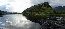
The Upper Lake is the smallest of the three lakes, and the southernmost. It is separated from the others by a winding channel some 4 km (2.5 mi) long. [1]

Folklore

According to folklore, the lakes were the haunt of Kate Kearney, who is said to have sought there O'Donaghue, an enchanted chieftain, and to have died in madness. Kearney is the subject of Letitia Elizabeth Landon's poetical illustration to a view of Wikisource-logo.svg The Upper Lake of Killarney . by William Henry Bartlett, [9] and in a further Landon poem, Wikisource-logo.svg Kate is Craz'd ., which accompanies a picture by Joseph John Jenkins. [10] This Kate Kearney should not be confused with the lady who provided refreshment at what is now Kate Kearney's Cottage at the Gap of Dunloe.

See also

Related Research Articles

<span class="mw-page-title-main">Killarney</span> Town in County Kerry, Ireland

Killarney is a town in County Kerry, southwestern Ireland. The town is on the northeastern shore of Lough Leane, part of Killarney National Park, and is home to St Mary's Cathedral, Ross Castle, Muckross House and Abbey, the Lakes of Killarney, MacGillycuddy's Reeks, Purple Mountain, Mangerton Mountain, Paps Mountain, the Gap of Dunloe and Torc Waterfall. Its natural heritage, history and location on the Ring of Kerry make Killarney a popular tourist destination.

<span class="mw-page-title-main">Glengarriff</span> Tourist village in County Cork, Ireland

Glengarriff is a village of approximately 140 people on the N71 national secondary road in the Beara Peninsula of County Cork, Ireland. Known internationally as a tourism venue, it has a number of natural attractions. It sits at the northern head of Glengarriff Bay, a smaller enclave of Bantry Bay.

<span class="mw-page-title-main">Ring of Kerry</span> Tourist route in Ireland

The Ring of Kerry is a 179-kilometre-long (111-mile) circular tourist route in County Kerry, south-western Ireland. Clockwise from Killarney it follows the N71 to Kenmare, then the N70 around the Iveragh Peninsula to Killorglin – passing through Sneem, Waterville, Cahersiveen, and Glenbeigh – before returning to Killarney via the N72.

<span class="mw-page-title-main">Aira Force</span> Waterfall in Matterdale, Cumbria

Aira Force is a waterfall in the English Lake District, in the civil parish of Matterdale and the county of Cumbria. The site of the waterfall is owned by the National Trust.

<span class="mw-page-title-main">Innisfallen</span>

Innisfallen or Inishfallen is an island in Lough Leane; one of the three Lakes of Killarney in County Kerry, Ireland. Innisfallen is home to the ruins of Innisfallen Abbey.

<span class="mw-page-title-main">Eskdale, Cumbria</span> Human settlement in England

Eskdale is a glacial valley and civil parish in the western Lake District National Park in Cumbria, England. It forms part of the Borough of Copeland, and in 2001 had a population of 264, increasing to 304 at the 2011 Census. One of the Lake District's most popular tourist attractions, the Ravenglass and Eskdale Railway, runs through the valley, though along with other western valleys of the Lake District, Eskdale is notably quieter during the high summer season than the more accessible eastern areas.

<span class="mw-page-title-main">Killarney National Park</span> National park in County Kerry, Ireland

Killarney National Park, near the town of Killarney, County Kerry, was the first national park in Ireland, created when the Muckross Estate was donated to the Irish Free State in 1932. The park has since been substantially expanded and encompasses over 102.89 km2 of diverse ecology, including the Lakes of Killarney, oak and yew woodlands of international importance, and mountain peaks. It has the only red deer herd on mainland Ireland and the most extensive covering of native forest remaining in Ireland. The park is of high ecological value because of the quality, diversity, and extensiveness of many of its habitats and the wide variety of species that they accommodate, some of which are rare. The park was designated a UNESCO Biosphere Reserve in 1981. The park forms part of a Special Area of Conservation and a Special Protection Area.

<span class="mw-page-title-main">Lough Leane</span> Lake in County Kerry, Ireland

Lough Leane is the largest of the three lakes of Killarney, in County Kerry. The River Laune flows from the lake into the Dingle Bay to the northwest.

<span class="mw-page-title-main">Kerry Way</span> Walking trail in County Kerry, Ireland

The Kerry Way is a long-distance trail in County Kerry, Ireland. It is a 214-kilometre (133-mile) long circular trail that begins and ends in Killarney and is typically broken into nine stages. It is designated as a National Waymarked Trail by the National Trails Office of the Irish Sports Council and is managed by Kerry County Council, South Kerry Development Partnership and the Kerry Way Committee. The Way circles the Iveragh Peninsula and forms a walkers' version of the Ring of Kerry road tour. It is the longest of Ireland's National Waymarked Trails.

<span class="mw-page-title-main">Carrick-a-Rede Rope Bridge</span> Bridge in County Antrim, Northern Ireland

The Carrick-a-Rede Rope Bridge is a rope bridge near Ballintoy in County Antrim, Northern Ireland. The bridge links the mainland to the tiny island of Carrickarede. It spans 20 metres (66 ft) and is 30 metres (98 ft) above the rocks below. The bridge is mainly a tourist attraction and is owned and maintained by the National Trust. In 2018, the bridge had 485,736 visitors. The bridge is closed for winter and people may cross it for a fee.

<span class="mw-page-title-main">Nakki Lake</span> Lake in Rajasthan, India

Nakki Lake is a lake situated in the Indian hill station of Mount Abu in Aravalli range.

<span class="mw-page-title-main">Torc Mountain</span> Mountain in Killarney, Ireland

Torc Mountain, at 535 metres (1,755 ft), is the 329th–highest peak in Ireland on the Arderin list. It is a popular mountain for hill walkers as it has a stone or boarded path from its base at Torc Waterfall to its summit, which has views of the Lakes of Killarney. Torc Mountain is part of the Mangerton Mountain Group range in County Kerry, Ireland.

<span class="mw-page-title-main">Treryn Dinas</span> Headland on the south coast of Cornwall, England

Treryn Dinas is a headland near Treen, on the Penwith peninsula between Penberth Cove and Porthcurno in Cornwall, England.

<span class="mw-page-title-main">Mangerton Mountain</span> Mountain in Killarney, Ireland

Mangerton or Mangerton Mountain, at 838 metres (2,749 ft), is the 19th-highest peak in Ireland on the Arderin list, and the 26th–highest mountain according to the Vandeleur-Lynam list. Mangerton is the tallest mountain in the Mangerton Mountain Group, also called the Mangerton Mountains or the Mountains of East Kerry, a range that includes five other major mountains that have a height above 2,000 feet (610 m). Mangerton's western slopes lie within the Killarney National Park. On Mangerton's north-western face lies a deep corrie lake called the Devil's Punchbowl, which is a popular scenic destination for hill walkers; although the mountain is often overlooked by walkers due to the proximity of its more scenic and accessible neighbour, Torc Mountain. The far northern slopes of Mangerton was the site of an important 13th-century battle between the Mac Cárthaigh, and the FitzGeralds, known as the "Tooreencormick battle site".

<span class="mw-page-title-main">Torc Waterfall</span> Waterfall in Killarney, Ireland

Torc Waterfall is a 20 metres (66 ft) high, 110 metres (360 ft) long cascade waterfall formed by the Owengarriff River as it drains from the Devil's Punchbowl corrie lake at Mangerton Mountain. The waterfall, which lies at the base of Torc Mountain, in the Killarney National Park, is 4.3 miles from Killarney in County Kerry, Ireland. The waterfall is a popular site on the Ring of Kerry and the Kerry Way tours.

<span class="mw-page-title-main">Polignac, Haute-Loire</span> Commune in Auvergne-Rhône-Alpes, France

Polignac is a commune in the Haute-Loire department in south-central France,

<span class="mw-page-title-main">Mamure Castle</span> Castle in Turkey

Mamure Castle is a medieval castle in the Bozdoğan village, Anamur ilçe (district) of Mersin Province, Turkey.

<span class="mw-page-title-main">James Thomson (engraver)</span> British engraver

James Thomson (1788–1850) was a British engraver, known for his portraits. He completed his apprenticeship in engraving and then established himself independently, following the dot and stipple style. His engravings and paintings featured both leading figures of his day and those of previous periods.

<span class="mw-page-title-main">Joseph John Jenkins</span> English painter

Joseph John Jenkins was a British engraver and watercolor painter. He is best known for his portraits and landscapes paintings.

<span class="mw-page-title-main">Muckross Lake</span> Lake in County Kerry, Ireland

Muckross Lake, also called Middle Lake or The Torc, is a lake in Killarney National Park, County Kerry, Ireland. It is one of the three famous Lakes of Killarney, along with Lough Leane and Upper Lake. It is Ireland's deepest lake, reaching to 75 metres (246 ft) in parts.

References

  1. 1 2 3 4 5 Scheffel, Richard L.; Wernet, Susan J., eds. (1980). Natural Wonders of the World. United States of America: Reader's Digest Association, Inc. pp. 204–205. ISBN   0-89577-087-3.
  2. 1 2 Guides, Rough (9 June 2015). The Rough Guide to Ireland. Penguin. ISBN   9780241236222.
  3. Dúchas. "The Lakes". Archived from the original on 15 June 2007. Retrieved 1 July 2007.
  4. "Official Killarney National Park Website". 7 February 2007. Archived from the original on 7 February 2007. Retrieved 24 March 2017.{{cite web}}: CS1 maint: bot: original URL status unknown (link)
  5. The Department of the Environment and Local Government. "Living with Nature: The Designation of Nature Conservation Sites in Ireland" (PDF). Archived from the original (PDF) on 27 September 2007. Retrieved 1 July 2007.
  6. p142-146, Richard Bradley The prehistory of Britain and Ireland, Cambridge University Press, 2007, ISBN   0-521-84811-3
  7. Ballantyne, Robert Michael (1 January 1865). The Lakes of Killarney. T. Nelson.
  8. Enterprise, Foran. "Killarney Lakes". www.gleannfia.com. Retrieved 24 March 2017.
  9. Landon, Letitia Elizabeth (1831). "picture". Fisher's Drawing Room Scrap Book, 1832. Fisher, Son & Co.Landon, Letitia Elizabeth (1831). "poetical illustration". Fisher's Drawing Room Scrap Book, 1832. Fisher, Son & Co.
  10. Landon, Letitia Elizabeth (1839). "poetical illustration". Fisher's Drawing Room Scrap Book, 1840. Fisher, Son & Co.Landon, Letitia Elizabeth (1839). "picture". Fisher's Drawing Room Scrap Book, 1840. Fisher, Son & Co.