
The Liard River of the North American boreal forest flows through Yukon, British Columbia and the Northwest Territories, Canada. Rising in the Saint Cyr Range of the Pelly Mountains in southeastern Yukon, it flows 1,115 km (693 mi) southeast through British Columbia, marking the northern end of the Rocky Mountains and then curving northeast back into Yukon and Northwest Territories, draining into the Mackenzie River at Fort Simpson, Northwest Territories. The river drains approximately 277,100 km2 (107,000 sq mi) of boreal forest and muskeg.
Telegraph Creek is a small community located off Highway 37 in northern British Columbia at the confluence of the Stikine River and Telegraph Creek. The only permanent settlement on the Stikine River, it is home to approximately 250 members of Tahltan First Nation and non-native residents. The town offers basic services, including Anglican and Catholic churches, a general store, a post office, a clinic with several nurses on-call around the clock, two Royal Canadian Mounted Police officers, and a K-9 school. Steep river banks and rocky gorges form the terraced nature of the geography.
The Liard River First Nation, also known as the Liard First Nation is a First Nation in the southeastern Yukon in Canada. Its main centres are Upper Liard and Watson Lake along the Alaska Highway. The language originally spoken by the people of this First Nation was Kaska and the First Nation is a member of the Kaska Tribal Council which is pursuing land claims in the Yukon and northern British Columbia. Their Indian and Northern Affairs Canada band number is 502.
Tahltan, Tāłtān, also called Tałtan ẕāke, dah dẕāhge or didene keh is a poorly documented Northern Athabaskan language historically spoken by the Tahltan people who live in northern British Columbia around Telegraph Creek, Dease Lake, and Iskut. Tahltan is a critically endangered language. Several linguists classify Tahltan as a dialect of the same language as Tagish and Kaska.
Dease Lake is a small community in the Cassiar Country of the Northern Interior of British Columbia, Canada. It is 230 km south of the Yukon border on Stewart–Cassiar Highway at the south end of the lake of the same name. Dease Lake is the last major centre before the Alaska Highway while driving northbound, and also the junction to Telegraph Creek and the Grand Canyon of the Stikine. Dease Lake Indian Reserve No. 9 is nearby and is under the governance of the Tahltan First Nation band government.

The Dease River flows through northwestern British Columbia, Canada and is a tributary of the Liard River. The river descends from Dease Lake, though its ultimate origin is in the headwaters of Little Dease Creek at Snow Peak, approximately 50 kilometres (31 mi) west of the lake. The river flows 265 kilometres (165 mi) generally north-eastward, draining into the Liard River near Lower Post, British Columbia. Large sections of the river parallel the Cassiar Highway, helping to make it a popular destination for canoeists, kayakers, and rafters.
Iskut is a small, mostly Indigenous community in the Stikine Country of northwestern British Columbia. It is located on Highway 37, at the north end of Eddontenajon Lake just south of Dease Lake and the crossing of the Stikine River.
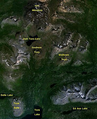
The Tuya Range is a mountain range in the Stikine Ranges of the Cassiar Mountains in the far north of the Canadian province of British Columbia, near its border with the Yukon Territory and to the southwest of Watson Lake, Yukon, which is the nearest major settlement.
The Cassiar Country, also referred to simply as the Cassiar, is a historical geographic region of the Canadian province of British Columbia. The Cassiar is located in the northwest portion of British Columbia, just to the northeast of the Stikine Country, while to the south is the Omineca Country. The area is noted for the Cassiar gold rush of the 1870s, when Laketon became its unofficial capital. The ghost town of Cassiar is also located in the Cassiar region.
Tahltan, or Goon-da-chagga or Goon-tdar-shaga is an unincorporated locality and Indian reserve community of the Tahltan people located east of Telegraph Creek in northern British Columbia, Canada, near the confluence of the Stikine and Tahltan Rivers. The local First Nations government is the Tahltan Band Council. The specific name of the Indian Reserve is Tahltan Indian Reserve No. 1. Other reserves in the immediate vicinity, also governed by this band, are Tahltan Forks Indian Reserve No. 5, Upper Tahltan Indian Reserve No. 4 and Hiusta's Meadow Indian Reserve No. 2.
Peter Warren Dease was a Canadian fur trader and Arctic explorer.
Dease Lake is a lake in the Stikine Plateau of the Northern Interior of British Columbia, Canada, located at the head of the Dease River, which flows north then northeast from the lake to join the Liard River. The community of Dease Lake, British Columbia, formerly Dease Lake Post, is located at the south end of the lake, straddling a low pass which leads into the basin from the Tanzilla River, a tributary of the Stikine. The area around the lake was the focus of the Cassiar Gold Rush and numerous ghost towns and former settlement sites are scattered around its shores, including Laketon and Centre City. Dease Lake is the burial site and has a monument to English travelogue writer Warburton Pike.
McDame, also known originally as McDame Post or McDames Creek Post and also known as Fort McDame is an abandoned settlement in the Cassiar Country of the Northern Interior of British Columbia,
The Tahltan First Nation, also known as the Tahltan Indian Band, is a band government of the Tahltan people. Their main community and reserves are located at Telegraph Creek, British Columbia. Their language is the Tahltan language, which is an Athabaskan language also known as Nahanni, is closely related to Kaska and Dunneza. Their Indian and Northern Affairs Canada band number is 682. The Tahltan First Nation is joined with the Iskut First Nation in a combined tribal council-type organization known as the Tahltan Nation.
Defot is a locality and former mining boomtown in the Cassiar Country of the Northern Interior of British Columbia, Canada, located west of Mount Defot.
Dease Creek is a creek located in the Stikine Region of British Columbia. This creek flows into the west side of Dease Lake. Dease Creek was first staked for gold in 1873 by the Moores. The creek was staked for 16 miles and in 1874 supported 700 miners. Mining companies such as Three to One, Preseverence, Canadian, Caledonia, and Baronovitch worked the creek. The total yield for the first five years was $1,054,400.00. The largest gold nugget recovered was in 1875 and weighed 50 ounces. By 1876 Chinese miners controlled most of the creek. The creek was considered to be mined out by 1880.

East Trinity is a coastal rural locality in the Cairns Region, Queensland, Australia. It was formerly known as Trinity East. In the 2016 census, East Trinity had a population of 212 people.
The Tanzilla River is a tributary of the Stikine River in northwest part of the province of British Columbia, Canada.
