United States Naval Construction Battalions, better known as the Navy Seabees, form the U.S. Naval Construction Force (NCF). The Seabee nickname is a heterograph of the initial letters "CB" from the words "Construction Battalion". Depending upon context, "Seabee" can refer to all enlisted personnel in the USN's occupational field 7 (OF-7), all personnel in the Naval Construction Force (NCF), or Construction Battalion. Seabees serve both in and outside the NCF. During World War II they were plank-holders of both the Naval Combat Demolition Units and the Underwater Demolition Teams (UDTs). The men in the NCF considered these units to be "Seabee". In addition, Seabees served as elements of Cubs, Lions, Acorns and the United States Marine Corps. They also provided the manpower for the top secret CWS Flame Tank Group. Today the Seabees have many special task assignments starting with Camp David and the Naval Support Unit at the Department of State. Seabees serve under both Commanders of the Naval Surface Forces Atlantic/Pacific fleets as well as on many base Public Works and USN diving commands.

The United States Virgin Islands, officially the Virgin Islands of the United States, are a group of Caribbean islands and an unincorporated and organized territory of the United States. The islands are geographically part of the Virgin Islands archipelago and are located in the Leeward Islands of the Lesser Antilles to the east of Puerto Rico and west of the British Virgin Islands.

Vredenburgh is a town in Monroe County, Alabama, United States. It incorporated in 1912. At the 2020 census, the population was 222.

Sylvia Alice Earle is an American marine biologist, oceanographer, explorer, author, and lecturer. She has been a National Geographic explorer-in-residence since 1998. Earle was the first female chief scientist of the U.S. National Oceanic and Atmospheric Administration, and was named by Time Magazine as its first Hero for the Planet in 1998.

The Virgin Islands National Park is an American national park preserving about 60% of the land area of Saint John in the United States Virgin Islands, as well as more than 5,500 acres of adjacent ocean, and nearly all of Hassel Island, just off the Charlotte Amalie, Saint Thomas harbor.
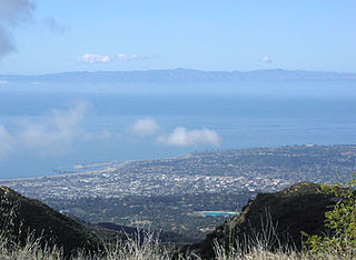
The Santa Barbara Channel is a portion of the Southern California Bight and separates the mainland of California from the northern Channel Islands. It is generally south of the city of Santa Barbara, and west of the Oxnard Plain in Ventura County.

Underwater habitats are underwater structures in which people can live for extended periods and carry out most of the basic human functions of a 24-hour day, such as working, resting, eating, attending to personal hygiene, and sleeping. In this context, 'habitat' is generally used in a narrow sense to mean the interior and immediate exterior of the structure and its fixtures, but not its surrounding marine environment. Most early underwater habitats lacked regenerative systems for air, water, food, electricity, and other resources. However, some underwater habitats allow for these resources to be delivered using pipes, or generated within the habitat, rather than manually delivered.
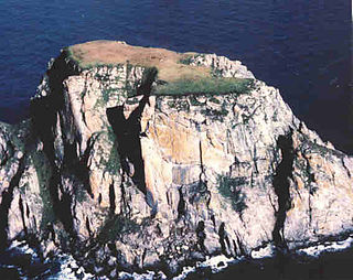
Fairway Rock (Iñupiaq: Ugiiyaq)(Census block 1047, Nome, Alaska) is a small islet with mostly vertical rock faces in the Bering Strait, located southeast of the Diomede Islands and west of Alaska's Cape Prince of Wales. Part of Alaska, an U.S. state, the islet has an area of 0.3 km2 (0.12 mi2). Known to Inuit of the Bering Strait region in prehistory, Fairway was documented by James Cook in 1778 and named by Frederick Beechey in 1826. Although uninhabited, the island is a nesting site for seabirds — most notably the least and crested auklet — which prompt egg-collecting visits from local indigenous peoples. The United States Navy placed radioisotope thermoelectric generator-powered environmental monitoring equipment on the island from the 1960s through the 1990s.

Cruz Bay, U.S. Virgin Islands is the main town on the island of Saint John in the United States Virgin Islands. According to the 2000 census, Cruz Bay had a population of 2,743.

Trunk Bay is a body of water and a beach on St. John in the United States Virgin Islands. Trunk Bay is part of the Virgin Islands National Park. Trunk Bay is named for the Leatherback turtle, which is endemic to the USVI and are locally known as trunks. The beach area is divided into two halves, the main Trunk Bay beach and swim area and Burgesman Cove which is located on the west end of Trunk Bay near Jumby Bay. Its amenities include a snack bar, showers and restrooms, a lifeguard, and an underwater trail for snorkeling its coral reef. Trunk Bay has consistently been voted one of the top beaches in the world.

A United States Navy diver refers to a service personnel that may be a restricted fleet line officer, civil engineer corps (CEC) officer, Medical Corps officer, or an enlisted who is qualified in underwater diving and salvage. Navy divers serve with fleet diving detachments and in research and development. Some of the mission areas of the Navy diver include: marine salvage, harbor clearance, underwater ship husbandry and repair, submarine rescue, saturation diving, experimental diving, underwater construction and welding, as well as serving as technical experts to the Navy SEALs, Marine Corps, and Navy EOD diving commands.
The Rausser College of Natural Resources (CNR), a college of the University of California, Berkeley, is the oldest college in the UC system and home to several internationally top-ranked programs. Rausser's Department of Agriculture & Economics is considered to be one of the most prestigious schools in agricultural economics in the world, ranking #1 according to the Journal of Agricultural and Applied Economics, #1 by the Chronicle of Higher Education, #1 by Perry for its Ph.D. programs and in International Trade, #1 by the National Research Council in Agricultural & Resource Economics, and #1 by U.S. News in Environmental/Environmental Health. In environmental disciplines, QS World Rankings recognizes the University of California, Berkeley, as the world's leading university in Environmental Studies with 100 points in Academic Reputation. U.S. News also ranks it as the best global university for environment and ecology. A study of AJAE authors and their university affiliations found it to have the highest number of pages per research faculty member.

The Tektite habitat was an underwater laboratory which was the home to divers during Tektite I and II programs. The Tektite program was the first scientists-in-the-sea program sponsored nationally. The habitat capsule was placed in Great Lameshur Bay, Saint John, U.S. Virgin Islands in 1969 and again in 1970.
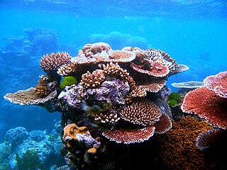
Coral reef protection is the process of modifying human activities to avoid damage to healthy coral reefs and to help damaged reefs recover. The key strategies used in reef protection include defining measurable goals and introducing active management and community involvement to reduce stressors that damage reef health. One management technique is to create Marine Protected Areas (MPAs) that directly limit human activities such as fishing.

Mount Loretto Unique Area is an open space reserve and nature preserve administered by the New York State Department of Environmental Conservation on the South Shore of Staten Island, New York City. The area's total size is 241 acres (98 ha), of which 49 acres (20 ha) is underwater.
Concordia is an area on the island of Saint John in the United States Virgin Islands. It is located on the south east corner of the island, near Salt Pond Bay. Much of the area is part of Virgin Islands National Park. Concordia Eco-Resort is located here.

Amphibious Construction Battalion TWO is an amphibious construction battalion in the United States Navy based in Little Creek, Virginia. Amphibious Construction Battalion ONE is its sister unit based in Coronado, California.
i-Tree is a collection of urban and rural forestry analysis and benefits assessment tools. It was designed and developed by the United States Forest Service to quantify and value ecosystem services provided by trees including pollution removal, carbon sequestration, avoided carbon emissions, avoided stormwater runoff, and more. i-Tree provides baseline data so that the growth of trees can be followed over time, and is used for planning purposes. Different tools within the i-Tree Suite use different types of inputs and provide different kinds of reports; some tools use a 'bottom up' approach based on tree inventories on the ground, while other tools use a 'top down' approach based on remote sensing data. i-Tree is peer-reviewed and has a process of ongoing collaboration to improve it.
Pacific Forest Trust is an accredited non-profit conservation land trust that advances forest conservation and stewardship solutions. Its mission is to sustain America’s forests for their public benefits of wood, water, wildlife, and people’s wellbeing, in cooperation with landowners and communities.
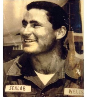
John Morgan Wells was a marine biologist, and physiologist involved in the development of decompression systems for deep diving, and the use of nitrox as a breathing gas for diving. He is known for developing the widely used NOAA Nitrox I and II mixtures and their decompression tables in the late 1970s, the deep diving mixture of oxygen, helium, and nitrogen known as NOAA Trimix I, for research in undersea habitats, where divers live and work under pressure for extended periods, and for training diving physicians and medical technicians in hyperbaric medicine.

