
Manila Bay is a natural harbor that serves the Port of Manila, in the Philippines. Strategically located around the capital city of the Philippines, Manila Bay facilitated commerce and trade between the Philippines and its neighboring countries, becoming the gateway for socio-economic development even prior to Spanish occupation. With an area of 1,994 km2 (769.9 sq mi), and a coastline of 190 km (118.1 mi), Manila Bay is situated in the western part of Luzon and is bounded by Cavite and Metro Manila on the east, Bulacan and Pampanga on the north, and Bataan on the west and northwest. Manila Bay drains approximately 17,000 km2 (6,563.7 sq mi) of watershed area, with the Pampanga River contributing about 49% of the freshwater influx. With an average depth of 17 m (55.8 ft), it is estimated to have a total volume of 28.9 billion cubic meters. Entrance to the bay is 19 km (11.8 mi) wide and expands to a width of 48 km (29.8 mi). However, width of the bay varies from 22 km (13.7 mi) at its mouth and expanding to 60 km (37.3 mi) at its widest point.

Calabarzon, sometimes referred to as Southern Tagalog and designated as Region IV‑A, is an administrative region in the Philippines. The region comprises five provinces: Batangas, Cavite, Laguna, Quezon, and Rizal; and one highly urbanized city, Lucena. It is the most populous region in the Philippines according to the Philippine Statistics Authority (PSA), having over 16.1 million inhabitants in 2020, and is also the country's second most densely populated after the National Capital Region. It is situated southeast of Metro Manila, and is bordered by Manila Bay and South China Sea to the west, Lamon Bay and the Bicol Region to the east, Tayabas Bay and the Sibuyan Sea to the south, and Central Luzon to the north. It is home to places like Mount Makiling near Los Baños, Laguna, and Taal Volcano in Batangas.

Mudflats or mud flats, also known as tidal flats or, in Ireland, slob or slobs, are coastal wetlands that form in intertidal areas where sediments have been deposited by tides or rivers. A global analysis published in 2019 suggested that tidal flat ecosystems are as extensive globally as mangroves, covering at least 127,921 km2 (49,391 sq mi) of the Earth's surface. They are found in sheltered areas such as bays, bayous, lagoons, and estuaries; they are also seen in freshwater lakes and salty lakes alike, wherein many rivers and creeks end. Mudflats may be viewed geologically as exposed layers of bay mud, resulting from deposition of estuarine silts, clays and aquatic animal detritus. Most of the sediment within a mudflat is within the intertidal zone, and thus the flat is submerged and exposed approximately twice daily.

Gumaca, officially the Municipality of Gumaca, is a 1st class municipality in the province of Quezon, Philippines. According to the 2020 census, it has a population of 71,942 people.

Calauag, officially the Municipality of Calauag, is a 1st class municipality in the province of Quezon, Philippines. According to the 2020 census, it has a population of 71,809 people.

Lopez, officially the Municipality of Lopez, is a 1st class municipality in the province of Quezon, Philippines. According to the 2020 census, it has a population of 94,657 people.

The intertidal zone or foreshore is the area above water level at low tide and underwater at high tide: in other words, the part of the littoral zone within the tidal range. This area can include several types of habitats with various species of life, such as seastars, sea urchins, and many species of coral with regional differences in biodiversity. Sometimes it is referred to as the littoral zone or seashore, although those can be defined as a wider region.

Quezon, officially the Province of Quezon, is a province in the Philippines located in the Calabarzon region on Luzon. Kaliraya/Kalilayan was the first known name of the province upon its creation in 1591. Around the middle of the 18th century, it was changed to Tayabas. In recognition of the second president of the Philippines, Manuel L. Quezon, the name of Tayabas Province is changed to Quezon. Lucena, the provincial capital, the seat of the provincial government, and the most populous city of the province, is governed independently from the province as a highly urbanized city. To distinguish the province from Quezon City, it is sometimes called Quezon Province.
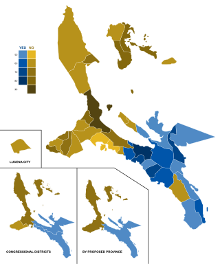
The Quezon del Sur creation plebiscite was a plebiscite on the creation of the province of Quezon del Sur from Quezon; the original Quezon province would have been renamed to "Quezon del Norte" had the plebiscite been approved by the residents of Quezon. The plebiscite was held on December 13, 2008, and the result was a slight majority rejecting the creation of the province.

Alabat Island is an island of the Philippine archipelago, in the Quezon Province of the Calabarzon region, situated just off the east coast of Southern Luzon. The island has an area of 192 square kilometres (74 sq mi) and a population of 41,822. The island has a mountain ridge with peaks ranging from 1,083 ft (330.10 m) to 1,384 ft (421.84 m) which look like islands at a distance. The highest peak is called Mt. Camagong.
Tayabas Isthmus, separates the Bicol Peninsula from the main part of Luzon Island, and the Bondoc Peninsula which lies between Tayabas Bay and Ragay Gulf. Luzon has a width of 120 to 160 kilometers but it narrows to 13 kilometers (8.1 mi) and not more than 15 kilometers (9.3 mi), when it comes to such straits. The isthmus is located between the Tayabas Bay and Lamon Bay.

A marine habitat is a habitat that supports marine life. Marine life depends in some way on the saltwater that is in the sea. A habitat is an ecological or environmental area inhabited by one or more living species. The marine environment supports many kinds of these habitats.
Local elections were held in the province of Quezon on May 13, 2013 as part of the 2013 general election. Voters will select candidates for all local positions: a town mayor, vice mayor and town councilors, as well as members of the Sangguniang Panlalawigan, the vice-governor, governor and representatives for the four districts of Quezon.

Pulo Island, commonly known as Isla Pulo, is a long, narrow island surrounded by mudflats in the Manila Bay coast of Navotas, about 13 kilometers (8.1 mi) north of Manila in the Philippines. It is a sitio in Barangay Tanza, connected to the mainland of Navotas by a 500-meter-long (1,600 ft) bamboo bridge. The island is known for its mangroves for which it was declared a "marine tree park" and as one of four ecotourism sites in Metro Manila established under the National Ecotourism Strategy in 1999. In 2014, it was home to a resettlement site of about 137 indigent families that mostly occupied the island's southern tip.
Atimonan, officially the Municipality of Atimonan, is a 1st class municipality in the province of Quezon, Philippines. According to the 2020 census, it has a population of 64,260 people.
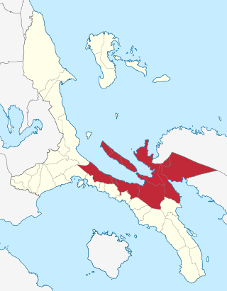
Quezon's 4th congressional district is one of the four congressional districts of the Philippines in the province of Quezon, formerly Tayabas. It has been represented in the House of Representatives of the Philippines since 1987. The district consists of municipalities in the Tayabas Isthmus and Alabat Island, namely Alabat, Atimonan, Calauag, Guinayangan, Gumaca, Lopez, Perez, Plaridel, Quezon and Tagkawayan. It is currently represented in the 19th Congress by Keith Micah Tan of the Nationalist People's Coalition (NPC).
The Roma Point Bridge, is a 1.7 km (1.1 mi) cable-stayed bridge under construction between the towns of Quezon and Calauag in Quezon, Philippines. The bridge will connect Alabat Island and its three municipalities of Perez, Alabat, and Quezon with the rest of Luzon Island, which are separated by the Silangan Pass. Once completed, it will be the longest bridge in Quezon Province and the Calabarzon Region.

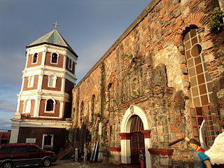
The San Diego de Alcala Parish Cathedral ;, commonly known as Gumaca Cathedral ;, is a Baroque-style, Roman Catholic cathedral located at Barangay San Diego Poblacion, in the town center of Gumaca, Quezon province, Calabarzon, Philippines. It is the seat and the mother church of the Roman Catholic Diocese of Gumaca.

Local elections were held in the Province of Quezon on May 9, 2022, as part of the 2022 general election. Voters will select candidates for all local positions: a town mayor, vice mayor and town councilors, as well as members of the Sangguniang Panlalawigan, the vice-governor, governor and representatives for the four districts of Quezon.


