Lands of Threepwood

Last updated

Lands of Threepwood
Beith, North Ayrshire, Scotland
UK grid reference NS393558
Cuffhill Reservoir.jpg
Cuffhill Reservoir from the site of the old Threepwood Bleach Works.
Scotland relief location map.jpg
Red pog.svg
Lands of Threepwood
Coordinates 55°46′09″N4°33′48″W / 55.76909°N 4.563425°W / 55.76909; -4.563425 Coordinates: 55°46′09″N4°33′48″W / 55.76909°N 4.563425°W / 55.76909; -4.563425
Grid reference NS 39287 55820
TypeLaird's dwelling and estate
Site information
OwnerPrivate
Controlled byMontgomerie
Open to
the public
No
ConditionIncorporated into a farm
Site history
Built18th century
Built byLove family
MaterialsStone

The lands of Threepwood were located in the Parish of Beith, at the eastern boundary between East Renfrewshire and North Ayrshire, Scotland. The settlements of Midtown, Townhead and Townend were part of the old Threepwood Estate. Cuffhill at 675 feet is the highest eminence in the parish and it overlooks the area with Little Hill and Cuff Hill and Little Hill plantations nearby, now situated next to the entirely artificial Cuffhill Reservoir.

Contents

History of the lands of Threepwood

The name 'Threepwood', 'Thriepwood' or 'Threppe-wood' [1] may derive from the Scots term 'Threap-wood' meaning a piece of woodland the ownership of which was disputed and found in Ayrshire as a place name. In Scottish history the term Threaplands referred to the Debatable Lands on the Scottish-English border. [2]

The Lairds

Avice de Morville, wife of Richard de Morville and daughter of William de Lancaster, Baron of Kendal, gave the lands of Threppe-wood to Kilwinning Abbey in the 12th century. [3] The lands in 1556 were leased by Gavin Hamilton, Commendator of Kilwinning Abbey, to Adam Hamilton of Holmhead. In 1557 Adam passed the lease to John Hamilton of Stanehouse for "thirteen score of merks, thirty bolls seeds oats, six bolls of bere, four oxen and a brown horse" [4] and a few months later John obtained a feu that passed the lands to the family in perpetuity for an annual payment. [5] In 1574 John passed the lands to his son James. In 1633 James Hamilton sold the lands to Robert Luiff or Love. [5]

Scotland relief location map.jpg
Red pog.svg
Threepwood
Threepwood House

The Loves previously held the name McKinnon and in 1613 a James Luiff appears to have lived at Threepwood judging from a stone at Threepwood that is inscribed 'I.L. & B.S. 1613' for James Luiff and Barbara Stewart. This Barbara may have been a close relation of Matho Stewart, a tenant of Threepwood under the abbacy's control. [6] The surname Love originated from the word for wolf, 'Luef' in French, and 'Lufe' or Luiff in the Scots dialect. [7]

Robert Love may have been their son and is described as being 'portioner of Threepwood' as he sold or sub-feued Townend Farm to Thomas Fulton and Midtoun or Mid Town to William Anderson. James Love, his son, married Barbara Stewart of Risk in Lochwinnoch parish in 1652 as recorded on a stone inscribed 'J.L. & B.S. 1652' and inherited the remaining lands of Threepwood in 1649. [6] Robert Love of Threepwood the younger inherited in 1693-94 and married in 1690 an Agnes Stevenston from Bra-Haugh near Neilston and another marriage stone at Threepwood records this. [8] In 1734 another Robert Love was born to James Love and Jean Robison of Wardyett and he inherited from his grandfather in 1769 as his father had died in 1743. [8] The last named Robert had a son of the same name who married twice, first to Janet Cochrane of Millthird and secondly to Jean Connell of South Castlewalls.

John Love was born in 1781 and was man of some importance, being a Commissioner of Supply, a Justice of the Peace and a Road Trustee. He purchased the lands of 'Tower of Auchenbathie, 'New Mill of Auchengown Stewart' and those of Netherhill near Dunlop. John married Jean Fulton of Sproulston. [9] Their eldest son Robert was a writer in Lochwinnoch who married Mary Hunter of Reivoch in 1844 and had an only daughter Mary Hunter Carswell Love. [9]

Threepwood

Threepwood Farm Threepwood Farm.JPG
Threepwood Farm

The lands of Threepwood lay in the Barony of Beith, Regality of Kilwinning and Bailiary of Cunninghame. The lands may have once reached as far as the Barrcraigs as the Cross of Brakraigs (sic) is shown on Blaeu's map suggesting that Kilwinning Abbey's lands extended to this point. [1] The march or boundary to the east was with the Barony of Auchinbathie, to the west were the lands of Auchingown Stewart and Brownmuir (Brimmer); to the south-west those of Hessilhead and to the south the march was the lands of Shutterflat. [4]

Roy's military map of 1747-55 shows a settlement named Townhead and another named Middletown but no mention of Threepwood. [10] Armstrong's map of 1775 marks Threepwood and shows two settlements that correspond in position to those recorded by Roy. [11] John Ainslie's 1821 map marks Threepwood and also a Townhead. [12] Thomson's 1832 map shows a laird's style dwelling of Threepwood and a group of two buildings below, also marked as Threepwood, with a lane running between. In 1828 'Bleachfield' is recorded with two separate buildings, one next to a millpond on the Cadgerford Burn and the other next to the Dusk Water. [13]

The three 'Towns' of Threepwood looks to have been the typical 'ferm toun' settlement arrangement such as at Hessilhead, the origin of which lies in the common medieval sub-division of land called a ploughgate (104 acres), the extent of land which one plough team of oxen could till in a year. This area was again subdivided into four husbandlands, each of 26 acres (110,000 m2). Each husbandland could provide two oxen and eight oxen were need for a plough-team. This arrangement led to small farm towns being established with accommodation for at least four men in six to eight houses, taking practical considerations into account. [14] Another similar 'ferm toun' also existed at Bloak, near Auchentiber, until the 1890s.

Threepwood House

First shown as a 'Laird's' house in 1832, by 1858 Threepwood House is shown above Mid Town as a substantial group of buildings with a square ornamental garden with internal paths lying in a walled garden immediately to the west of the house. [15] An older house has had byres and other outbuildings built to transform the house into a farm. Substantial woodland policies were planted nearby with Tandle Hill nearby.

Mid Town of Threepwood

The oldest ruins at Mid Town of Threepwood Mid Town Ruins 1, Threepwood.JPG
The oldest ruins at Mid Town of Threepwood

Mid Town Farm was obtained by William Anderson in the 1630s from Robert Love of Threepwood. [6] In 1858 the settlement is marked with a single roofed building and a ruin that abuts onto the lane leading up to Threepwood House. [15] In 1895 Mid Town is shown as a ruin. [16]

Town Head of Threepwood

In 1858 Town Head is shown as a single building accessed from the west [15] and in 1895 it is roofless, [16] but a new private dwelling has been built at the site in recent times.

Townend of Threepwood

Wall feature at Townend of Threepwood a possible 'Jug' hatch Town End of Threepwood, feature.jpg
Wall feature at Townend of Threepwood a possible 'Jug' hatch

In the 1630s Townend Farm was obtained from Robert Love by Thomas Fulton. [6] Hugh Stevenson was the farmer at Townend of Threepwood Farm in the early 19th century and after his death his sons succeeded him, later however the lands were divided and sold. The Barn-fauld field was purchased by John Love, Esq., of Threepwood. Circa 1847 the area was surveyed and divided off from the other portion of the property which was then purchased by Robert Shedden Patrick, Esq., of Trearne and Hazlehead. In 1646 a John Fulton is recorded as dwelling at the farm of Boydston near Mill of Beith. [17]

John Shedden of Marshalland, called "The Lang Laird" because of his height, married Mary Stevenson of Townend of Threepwood. The couple had five daughters and one son, John, known as "Jack the Marshalland" or "The Gem-keeper". [18]

Jack the Marshalland
'Jug' hatch at the old Bucks Head Tavern in Stewarton. Buck's Head Inn - old hatch.JPG
'Jug' hatch at the old Bucks Head Tavern in Stewarton.

Born on 25 April 1756, John Shedden of Marshalland married Mary Raeside in 1836, however they had no offspring. John was a tall man, strong and a notorious poacher of hares at a time when poaching was governed by archaic laws. [18] After several court appearances Jack moved to a large estate in England where he worked as the head gamekeeper, earning a good wage and returning with substantial savings. On his return he became ironically known as "The Gem keeper" and when he died his poacher friend Thomas Stevenson fired off his gun to the "rict and left" over his grave, much to the surprise of George Colville, the minister at the time. [19]

Uses

In 1858 a group of buildings are shown here with three unroofed and two in use. The road widened here on both sides and a small building with a nearby well lay on the northern side, the southern side having two out of three buildings that faced the road still roofed, although the shed or byre attached to the westernmost is shown as a ruin. A sizeable rectangular enclosure lies to the west on the other side of the access driveway to Sunnyside of Threepwood. In 1895 only the westernmost building appears to be in use and the others are not even marked. [16] The single building is still shown as roofed in 1908 [20] and 1912. [21]

At first a farm, the site lost most of the buildings until only one remained in 1908. A busy area in terms of horse drawn transport along Threepwood Road and pedestrian traffic so that the building may have provided accommodation for travellers and/or bleach works employees. The unusual 'window' at the back resembles the 'Jug' windows found in pubs where a jug or bottle of beer was filled and taken away to be consumed elsewhere as recorded in this poem about 'The Den' at Barkip -

The Auld Hoose is stinnin yet, we kent it best by Pugs,
But there's no a buddy rinnin noo, wi bottles or wi jugs.
For noo its lost its license, an' there's no a drap ava,
Though miny a bottle has been selt, through the wee hole in the wa'.

The narrow 'layby' on the roadside with a well and small building suggests water and food for horses.

Threepwood Bleach Works

A bleachfield Bleekveld.jpg
A bleachfield

Cotton cloth or linen was originally bleached by repeatedly steeping it in an alkaline solution or lye derived from ash tree or fern ashes, called 'bucking'. [22] The treated cloth was then washed and exposed to sunshine and air by being hung out in bleachfields or 'crofts'. After being immersed in buttermilk, called ‘souring’ it was given a further wash, and then dried. The process was very time-consuming and could take up to eight months to 'buck', 'sour' and finally dry. [23]

Two separate bleach works are marked on the Ordnance Survey maps and areas of open ground are indicated which would have been the bleachfields. Ample supplies of water were available from the Cadgerford Burn and the Dusk Water that run through the area. Supplies of lye made from ash tree ashes would have been plentiful in this well wooded district. In 1828 the 'Bleachfield' is recorded with two buildings in different areas that are probably the bleach works. The largest bleach works lay next to a millpond fed by the Cadgerford Burn that supplied water for both the 'bucking' process and power for the waterwheel. [13] Dye works buildings lay close by with a path marked that also ran to the other bleach works site that lay next to the Dusk Water with a wooden bridge over the watercourse. [15] By 1895 both bleach works and the dye house are shown as ruins on the OS maps [16] which links with the discovery of chlorine on the late 18th century after which Bleach works and the associated bleachfields became redundant.

By 1855-57 the works are recorded in the Ordnance Survey name book as bleaching linen thread, worked by water and providing accommodation for workers. A Mr John Stevenson was the occupier whilst the Love family were the proprietors. [24]

Lows Cottage near Coldhame was a retting works and was located next to one of the Lowes Lochs which was used as a retting pond for flax preparation. Davie's o'the Mill lay nearby and is thought to have been a flax or lint mill, leading to the suggestion that these industrial activities all located along Threepwood Road and nearby may have been inter-dependent business ventures. A flax or lint mill also once existed near Brownmuir on the Muir Burn. Flax made into linen was also used in the manufacture of thread by the Crawford Brothers, first in Beith and later in Barrmill. [25]

Sunnyside of Threepwood

In between the two bleach works in 1858 is located a building with a very ornate walled garden, in all likelihood the dwelling of the works manager and has two dated stones of the marriage stone type, dated 1790 with 'I(J)R and JC' and 1759 respectively. The second stone is badly eroded and any initials are not discernable. [15] This relatively small building also has an access off Threepwood Road via the settlement of Townend. [15] In 1858 no name is given on the map to this dwelling. A plantation or screen of trees is shown lying to the west and a small ruin is shown on the lane to the lower bleach works where it ceases to be straight and runs in an easterly direction.

1790 Marriage Stone IR and AC 1790.JPG
1790 Marriage Stone

In 1895 the name Sunnyside of Threepwood is used on the map and the dwelling has increased considerably in size with the oldest section lying to the east. The ornamental garden is no longer featured. [16] It may be no coincidence that the name 'Sunnyside' is attached to the dwelling as Thomson's map shows that this was the open south facing site of the old bleachfield where the bleached cloth was dried. [13]

The Weaver's or Threepwood Well

The Weaver's or Threepwood Well. Threepwood or Weaver's Well - detail.JPG
The Weaver's or Threepwood Well.

Close to Coldhame Cottage on the verge before the turning to Brownmuir Farm is a rare survival, the Weaver's or Threepwood Well, a freshwater spring that exits the rock in a steady flow that runs into a shallow excavation with a stone border, surrounded by heather, ferns, mosses, wild rose, whortleberry, willow moss, etc. The well was the site of the 'Weaver's Parliament' where the local weavers would meet to discuss business and other matters of importance. Lint or flax mills were located nearby and weavers would have been involved in producing the linen that was then bleached at the Sunnyside of Threepwood bleach works. The well sits on Threepwood Road which was on the route tp Paisley where the weavers sold most of their finished products. [26]

Cuffhill reservoir

The 'Lower Reservoir' is first shown on the 1895 OS map and it is indicated that it is managed by the Beith Water Committee. [16] In 1908 the reservoir with its dam and sluice are shown as managed by Ayr County Council. [20]

The Cadgerford Burn

The Cadgerford Burn. Cadgerford Burn.jpg
The Cadgerford Burn.

The name of the inflow and outflow burn indicates, as stated, a ford on this old road once used by cadgers or carriers on horseback of goods, including items such as Dunlop cheeses. The burn is the existing inflow and outflow from Lowes Loch to the Dusk Water. The burn now flows into the Kirkleegreen Reservoir, built after 1858 and by 1891. [27] The waters of this old reservoir, now an angling loch, run into Cuffhill Reservoir and then into the Dusk Water. The ford may have been where a culvert now carries the outflow of the small loch in front of Lows Cottage down towards Lowes Loch.

Beith's annual fair, called Tennant's or Saint Tinnan's Day, was previously held on the Cuff Hill [28] It was famous for its show, and its Cadger's parade and sale of horses. [29]

Archaeology

Detail of the Cuff Hill rocking stone. Cuff Hill logan stone 1.JPG
Detail of the Cuff Hill rocking stone.
The Druid's Grave on Cuff Hill. Druid's Grave - Cuff Hill.jpg
The Druid's Grave on Cuff Hill.

The Cuff Hill rocking stone (NS 3827 5542) is a large glacial erratic boulder of basaltic greenstone [30] that some people associate with the Druids. It no longer rocks due to people digging beneath to ascertain its fulcrum. [31] It is in a small wood and surrounded by a circular drystone wall.

On Cuff Hill were once located a group of four standing stones, also the Druid's Grave and the likely site of a pre-reformation chapel at Kirklee Green.

Hugh Stevenson of Townend of Threepwood was ploughing in Barn-fauld in the late 17th century when his plough hit an area of loose stones and a large pot was revealed containing bones and inside was a smaller object that has been described as small urn of the 'incense-cup' type.

Smith records that a Law Mound was located at Threepwood, twelve paces in diameter, [32] however this place name is not marked on OS maps and is seemingly unknown by local inhabitants.

An arrowhead, bone comb and stone implement were found (NGR NS 388 554) near Sunnyside of Threepwood. [33]

Finkillgreen on the lands of Threepwood is described as a grass covered rocky knoll on which a rocking-stone was situated. In the 1860s this stone could be easily rocked with one hand. [34]

The roads

Threepwood Road was a 'Statute Labour Road' maintained under Act of 1669 which required the appointment each year of overseers who would require tenants, cottars and servants to do unpaid work on the road. There were penalties for absence and the Heritors were obliged to supply funds for repair with tolls raised. [35]

The 'Parish' road was built in 1810 and the Druids Graves cairn was robbed for stone to build it. [36] On 30 December 1767 the Turnpike Committee looked at the road from Beith to Coldstreem (sic) Bridge. They felt it was not suitable for upgrading and that a new line would be both easier and shorter. The old road went over the hill between the Park Dykes of Overtoun and Cuff via Threepwood. [37]

Micro-history

A New Zealand flatworm (Arthurdendyus triangulatus) was found near Sunnyside of Threepwood in 2014. This introduced species eats earthworms and was once seen as potential threat to native earthworm populations. Bleachfield Grangehill was a cottage that stood by an old bleachfield. The lint mill near Brownsmuir was still operational in 1855-57.

Related Research Articles

Barony and Castle of Corsehill Barony in East Ayrshire, Scotland

The old Barony and castle of Corsehill lay within the feudal Baillerie of Cunninghame, near Stewarton, now East Ayrshire, Scotland.

Dunlop, East Ayrshire Human settlement in Scotland

Dunlop is a village and parish in East Ayrshire, Scotland. It lies on the A735, north-east of Stewarton, seven miles from Kilmarnock. The road runs on to Lugton and the B706 enters the village from Beith and Burnhouse.

Lugton Human settlement in Scotland

Lugton is a small village or hamlet in East Ayrshire, Scotland with a population of 80 people. The A736 road runs through on its way from Glasgow, 15 miles (24.1 km) to the north, to Irvine in North Ayrshire. Uplawmoor is the first settlement on this 'Lochlibo Road' to the north and Burnhouse is to the south. The settlement lies on the Lugton Water which forms the boundary between East Ayrshire and East Renfrewshire as well as that of the parishes of Dunlop and Beith.

Hessilhead

Hessilhead is in Beith, North Ayrshire, Scotland. Hessilhead used to be called Hazlehead or Hasslehead. The lands were part of the Lordship of Giffen, and the Barony of Hessilhead, within the Baillerie of Cunninghame and the Parish of Beith. The castle was situated at grid reference NS380532.

Barony and Castle of Giffen Barony in the former District of Cunninghame, now North Ayrshire

The Barony of Giffen and its associated 15th-century castle were in the parish of Beith in the former District of Cunninghame, now North Ayrshire. The site may be spelled Giffen or Giffin and lay within the Lordship of Giffin, which included the Baronies of Giffen, Trearne, Hessilhead, Broadstone, Roughwood and Ramshead; valued at £3,788 9s 10d. The Barony of Giffen comprised a number of properties, including Greenhills, Thirdpart, Drumbuie, Nettlehirst and Balgray, covering about half of the parish of Beith. Giffen was a hundred merk land, separated from the Barony of Beith, a forty-pound land, by the Powgree Burn which rises on Cuff hill. The Lugton Water or the Bungle Burn running through Burnhouse may have been the Giffen barony boundary with that of the adjacent barony and lands of Aiket castle.

Spiers School

Spier's School, at Beith, in North Ayrshire, Scotland was opened in 1888 and closed in 1972. The school, now demolished, was built using Ballochmyle red sandstone and was reminiscent of the ancient Glasgow University. The school motto was 'Quod verum tutum'. The gardens and woodlands are open to the public at all times.

Broadstone Castle

Broadstone lies close to the small village of Gateside in North Ayrshire, Scotland about half a mile east of Beith in the old Barony of Giffen.

Hill of Beith Castle

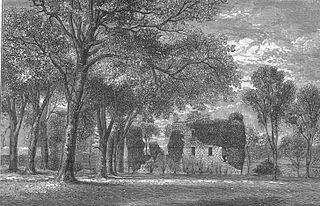
The old Barony and castle, fortalice, or tower house of Hill of Beith lay in the feudal Regality of Kilwinning, within the Baillerie of Cunninghame, and the Sherrifdom of Ayr, now the Parish of Beith, North Ayrshire, Scotland.

The Lands of Ashgrove

The Lands of Ashgrove, previously known as Ashenyards, formed a small estate in the Parish of Kilwinning, North Ayrshire, lying between Kilwinning and Stevenston. The Georgian mansion house was demolished in 1960, the substantial walled garden survives.

Nettlehirst

Nettlehirst or Nettlehurst was a small mansion house (NS365504) and estate in the Parish of Beith, near Barrmill in North Ayrshire, Scotland. The house was built in 1844 and burned down in 1932.

Lowes Loch (Ayrshire) Lake in the United Kingdom

Lowes Loch, The Lochs or Loch of Hill is now a small natural freshwater loch in the North Ayrshire Council Areas, lying in a glacial kettle hole, once of greater extent, lying below Brownmuir and Lochland Hills on the Threepwood Road, near Beith, in the Parish of Beith. The loch may once have had a small island within it.

Auchenbathie Tower

Auchenbathie, Auchinbathie Tower or rarely Barcraigs Tower is a ruined fortification, a tower house, once held by the Wallace Clan of Elderslie, situated in Renfrewshire, Parish of Lochwinnoch, Scotland. The spelling used varies greatly and "Auchenbathie" will be used here as the standard spelling. The pronunciation locally is "Auchenbothy", the same as a Victorian mansion in Kilmacolm; no connection is known.

Lands of Bogston

Bogston or later Bogstone was a small estate in the old Barony of Giffen near Barrmill in the Parish of Beith, North Ayrshire, once held by collateral descendants of the Montgomeries of Broadstone. The estate covered 160 acres or around 65 hectares, its rental in 1896 being £180 per annum.

The Lands of Roughwood

Roughwood once Ruchwood is a farm, originally a estate, possessing at one time a small tower castle. Roughwood is situated near to the town of Beith in North Ayrshire, Scotland; the lands lay within the old Lordship of Giffen.

Lands of Doura

The Lands of Doura, Dawra, Dawray, DowreyDowray, Dourey or Douray formed a small estate, at one time part of the Barony of Corsehill and Doura, situated near the Eglinton Estate in the Parish of Kilwinning, North Ayrshire, Scotland.

Lands of Willowyard

The ancient lands of Willowyard, Willieyeards, Williyard or Willizeards were part of the holdings of the Regality of Kilwinning, Barony of Beith, and Bailiary of Cuninghame. They later became the property of the Montgomerie family before being sold to the Simson family in 1723. The manor house still survives as part of a business premises and the nearby industrial estate and whisky bond carry the name 'Willowyards'.

Lands of Marshalland

The lands of Marshalland, Marsheland, Marsheyland or Marshyland were part of the holdings of the Barony of Beith, Regality of Kilwinning and Bailiary of Cuninghame. They became the property of the Lyle family, then the Shedden family, passing next to the Spier's family before finally becoming part of the Spier's Trust lands. The laird's house and farm were demolished in the 1960s.

Lands of Morishill

The lands of Morishill,Morrishill,Moorishill or Moricehill were part of the holdings of the Barony of Beith, Regality of Kilwinning and Bailiary of Cuninghame. The name may have derived from large shielings or huts that were once erected at the site.

Lands of Brownmuir

The lands of Brownmuir, Brown Muir (1832) or Brimmer (1821) in Scots were located in the Parish of Beith, at the western boundary between East Renfrewshire and North Ayrshire, Scotland. The settlements of Brownmuir and Rakerfield were part of the old Brownmuir Estate. Brownmuir or Brimmer Hill at feet is a prominent eminence in the parish and it overlooks the area with Lochlands Hill and Cuff Hill relatively nearby. The old estate of Threepwood lay to the east.

Lands of Tour and Kirkland Human settlement in Scotland

The Lands of Tour and Kirkland (NS416406) formed a small estate close to the old Kirktoun and St Maurs-Glencairn collegiate church about 1 km south-east of Kilmaurs, East Ayrshire, Parish of Kilmaurs, Scotland. The word 'Tour' in Scots refers to a 'tower' and 'kirk' to a parish church.

References

Notes;

  1. 1 2 Paterson, p. 115
  2. Dictionary of Scots Retrieved 2013-11-12
  3. Dobie, p. 255
  4. 1 2 Paterson, p. 116
  5. 1 2 Paterson, p. 117
  6. 1 2 3 4 Paterson, p. 118
  7. The Legend of the Luiff Retrieved 2013-11-17
  8. 1 2 Paterson, p. 119
  9. 1 2 Paterson, p. 120
  10. Roy's Military Map Retrieved 2013-11-12
  11. Armstrong's Map Retrieved 2013-11-12
  12. John Ainslie's Map Retrieved 2013-11-12
  13. 1 2 3 Thomson's 1828 Map Retrieved 2013-11-13
  14. Dickinson, p. 218
  15. 1 2 3 4 5 6 1858 OS 6" Map Retrieved 2013-11-13
  16. 1 2 3 4 5 6 25" OS Map Retrieved 2013-11-13
  17. Paterson, p. 84
  18. 1 2 Dobie (1896), p. 193
  19. Dobie (1896), p. 194
  20. 1 2 1910 25" OS Map Retrieved 2013-11-13
  21. 6" OS Map Retrieved 2013-11-13
  22. Wood-ash Lye Retrieved 2013-11-13
  23. Ashes in the Washtub Retrieved 2013-11-13
  24. OS Name Book of 1855-57
  25. Reid (2000), p. 52
  26. Porterfield, p. 9
  27. Reid, p. 69
  28. Smith, p. 40.
  29. Dobie, p. 324
  30. RCAHMS Canmore Retrieved 2013-11-13
  31. Topographical Description of Ayrshire; more Particularly of Cunninghame: together with a Genealogical account of the Principal families in that Bailiwick., George Robertson, Cunninghame Press, Irvine, 1820
  32. Smith, p. 84
  33. RCAHMS Retrieved 2013-11-12
  34. Smith, p. 81
  35. OS Name Book of 1855-57
  36. Smith, p. 79
  37. Old Roads of Ayrshire Retrieved 2014-04-13

Sources and Bibliography;

  1. Dickinson, William Croft, Donaldson, G., and Milne, I. a. (1958), A Source Book of Scottish History. V. One. Pub. T. Nelson & Sons, London.
  2. Dobie, James D. (ed Dobie, J.S.) (1876). Cunninghame, Topographized by Timothy Pont 1604–1608, with continuations and illustrative notices. Glasgow: John Tweed.
  3. Dobie, James (1896). Memoir of William Wilson of Crummock. Edinburgh: James Dobie.
  4. Kinniburgh, Moira & Burke, Fiona (1995). Kilbirnie & Glengarnock. Shared Memories. Kilbirnie Library. ISBN   1-897998-01-5.
  5. Love, Dane (2003). Ayrshire: Discovering a County. Ayr: Fort Publishing. ISBN   0-9544461-1-9.
  6. Paterson, James (1863–66). History of the Counties of Ayr and Wigton. IV. - I - Cunninghame. Edinburgh: J. Stillie.
  7. Porterfield, S. (1925). 'Rambles Round Beith'. Pilot Press.
  8. Reid, Donald L. (2000). The Beith Supplement - The Story of Beith's Newspaper. Beith: Duke of Edinburgh Award. ISBN   0-9522720-1-6.
  9. Reid, Donald (2001). In the Valley of the Garnock (Beith, Dalry & Kilbirnie. Beith: DoE. ISBN   0-9522720-5-9.
  10. Reid, Donald L. (2011). Voices & Images of Yesterday and Today. Beith, Barrmill, and Gateside. Precious Memories. Irvine: Kestrel Press. ISBN   978-0-9566343-1-3.
  11. Robertson, George (1820). Topographical Description of Ayrshire: Cunninghame. Irvine: Cunninghame Press.
  12. Smith, John (1895). Prehistoric Man in Ayrshire. London: Elliot Stock.
  13. Strawhorn, John and Boyd, William (1951). The Third Statistical Account of Scotland. Ayrshire. Edinburgh: Oliver & Boyd.
  1. YouTube video of the Druids Graves
  2. YouTube video of the Cuffhill Rocking or Logan Stone
  3. YouTube video of Cuffhill Reservoir
  4. YouTube video of Threepwood Spout on the Cadgerford Burn.
  5. YouTube video and narration regarding a John Muir Award project at Threepwood
  6. YouTube video and narration at Townend of Threepwood ruins
  7. YouTube video and narration for the Weaver's or Threepwood Well on YouTube
  8. YouTube video and narration on the Low House retting pond
  9. YouTube video and narration on the High Bogside rifle range
  10. YouTube video and narration on the Threepwood Bleach and Dye works