Cleveland is a land of hills and dales from the River Tees to Vale of Pickering, England. The name Cleveland comes from a variant of "cliff-land", referring to Yorkshire's Moors.

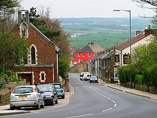
Guisborough is a market town and civil parish on the south side of the River Tees in North Yorkshire, England, in the borough of Redcar and Cleveland. It previously formed its own royal borough as a district of the North Riding of Yorkshire. Guisborough ward had a population of 7,662 at the 2011 census. The civil parish, including outlying Upleatham, Dunsdale and Newton under Roseberry, had a population of 17,777.

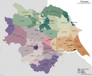
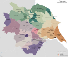
The North Riding of Yorkshire is one of three historic subdivisions (ridings) of the English county of Yorkshire, alongside the East and West ridings. From the Restoration it was used as a lieutenancy area, having been previously part of the Yorkshire lieutenancy. Each riding was treated as a counties for many purposes, such as quarter sessions.

The Borough of Redcar and Cleveland is a borough and unitary authority area in the North East of England, within the ceremonial county of North Yorkshire. The main settlements are Redcar, Saltburn-by-the-Sea, Guisborough, and towns and villages of Brotton, Eston, Grangetown, South Bank, Kirkleatham, Loftus and Skelton. It had a resident population of 135,200 in 2011.

The Borough of Scarborough is a non-metropolitan district and borough of North Yorkshire, England. In addition to the town of Scarborough, it covers a large stretch of the coast of Yorkshire, including Whitby and Filey. It borders Redcar and Cleveland to the north, the Ryedale and Hambleton districts to the west and the East Riding of Yorkshire to the south.

Tees Valley is a combined authority area in the north of England around the River Tees. The combined authority was established in 2016, after public consultation in 2015. The area is not a geographical valley.

Lythe is a small village and large civil parish, in the Scarborough district of North Yorkshire, England, situated near Whitby within the North York Moors National Park. The name of the village derives from Old Norse and means hill or slope.

Redcar is a constituency represented in the House of Commons of the UK Parliament since 2019 by Jacob Young, a Conservative.

Middlesbrough South and East Cleveland is a constituency created in 1997 represented in the House of Commons of the UK Parliament since 2017 by Simon Clarke of the Conservative Party. The local electorate returned a Labour MP in the seat's first five general elections; in the following election Clarke became its first Conservative MP.

Normanby is an area in Redcar and Cleveland, North Yorkshire, England. It is part of the Teesside Built-up Area's Borough of Middlesbrough sub-division. It has a population of approximately 7,000 residents and lies between Ormesby (west), Eston (east), Guisboroug (south-west) while Teesville and South Bank are to the north.

Brotton is a village in the civil parish of Skelton and Brotton in the borough of Redcar and Cleveland in the North East of England. The village lies within the ceremonial county of North Yorkshire and is governed by the unitary authority of Redcar and Cleveland. It is situated approximately 2.5 miles (4 km) south-east of Saltburn-by-the-Sea, 12 miles (19 km) east of Middlesbrough and 14 miles (23 km) north-west of Whitby. In 2011, the village had a population of 5,394.

Langbaurgh was a liberty or wapentakes of Yorkshire, North Riding. It covered an area of the shire's north-eastern tip. The wapentake took its name from Langbaurgh hamlet, in present day Great Ayton parish.

Grangetown is a town in the borough of Redcar and Cleveland, North Yorkshire, England.

Langbaurgh was a parliamentary constituency in the Langbaurgh area of North East England to the east of Middlesbrough. It returned one Member of Parliament (MP) to the House of Commons of the Parliament of the United Kingdom, elected by the first past the post system, and existed from 1983 to 1997.

Langbaurgh West was a division of the wapentake of Langbaurgh in the North Riding of the ancient county of Yorkshire. The area along with Langbaurgh East forms the Anglo-Saxon baronial Liberty of Cleveland and roughly covers the modern districts of Middlesbrough, the western, urbanised portion of Redcar & Cleveland, the southern portion of Stockton-on-Tees, the northern parts of Hambleton and the northern parts of the Borough of Scarborough.

Lockwood is a civil parish in the unitary authority of Redcar and Cleveland with ceremonial association with North Yorkshire, England. The population of Lockwood ward in the Redcar and Cleveland Unitary authority taken at the 2011 census was 2,022.

Cleveland was a ceremonial county located in northern England. It was created in 1974 under the Local Government Act 1972, named after a historic area in Yorkshire, including land from Hartlepool to between Redcar and Whitby. The county was abolished in 1996.

The Yorkshire Coast is a world-famous stretch of coastline that runs from the Tees estuary to the Humber estuary on the east coast of England. The cliffs at Boulby are the highest on the east coast of England rising to 660 feet (200 m) above the sea level.

Kilton Castle is a ruined castle overlooking the valley of Kilton Beck, near to the village of Kilton in the historic county of the North Riding of Yorkshire in England. The castle was built in the 12th century and was described as being in a ruinous state by the 14th century, with it being totally abandoned by the 16th century. Kilton Castle was owned by several noble families who hailed from the area; de Brus, de Kilton, Autrey, de Thweng, de Lumley.

Kettleness, is a hamlet in the Scarborough District of North Yorkshire, England. The settlement only consists of half-a-dozen houses, but up until the early 19th century, it was a much larger village. However, most of that village, which was on the headland, slipped into the sea as a result of instability caused by quarrying for the alum industry. Kettleness became a smaller settlement, with houses rebuilt slightly further inland.


