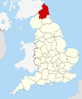
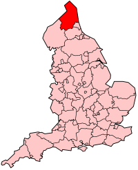
Northumberland is a unitary authority and historic county in North East England, the northernmost county of England. The unitary authority borders Cumbria to the west, County Durham and Tyne and Wear to the south and the Scottish Borders to the north. To the east is the North Sea coastline with a path 103 kilometres (64 mi) long. The county town is Alnwick, although the county council is based in Morpeth.

Prudhoe is a town in south Northumberland, England, about 11 miles (18 km) west of the city of Newcastle upon Tyne and just south of the River Tyne. The town is sited on a steep, north-facing hill in the Tyne valley and nearby settlements include Ovingham, Ovington, Wylam, Stocksfield, Crawcrook, Hedley on the Hill and Mickley. Prudhoe has a population of over 11,500, measured at 11,675 in the 2011 Census. Today, it has largely become a commuter town for nearby Newcastle.

Corbridge is a village in Northumberland, England, 16 miles (26 km) west of Newcastle and 4 miles (6 km) east of Hexham. Villages nearby include Halton, Acomb, Aydon and Sandhoe.

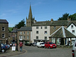
Hexham is a market town and civil parish in the south west of Northumberland, England, on the south bank of the River Tyne which forms by the confluence of two rivers: the North Tyne and the South Tyne. These two rivers converge at Warden Rock near Hexham at a place dubbed 'The Meeting of the Waters'. Hexham area has part of the Hadrian's wall. Hexham was the administrative centre for the Tynedale district from 1974 to 2009. In 2011, it had a population of 11,829.
Alston is a town in Cumbria, England, within the civil parish of Alston Moor on the River South Tyne. It shares the title of the 'highest market town in England', at about 1,000 feet (300 m) above sea level, with Buxton, Derbyshire. Despite its altitude, the town is easily accessible via the many roads which link the town to Weardale, Teesdale, and towns in Cumbria such as Penrith via Hartside Cross, as well as Tynedale. Historically part of Cumberland, Alston lies within the North Pennines, a designated Area of Outstanding Natural Beauty. Much of the town centre is a designated Conservation Area which includes several listed buildings.

Tynedale is an area and former local government district in south-west Northumberland, England. The district had a resident population of 58,808 according to the 2001 Census. Its main towns were Hexham, Haltwhistle and Prudhoe. The district contained part of Hadrian's Wall and the southern part of Northumberland National Park.

Haltwhistle is a small town and civil parish in Northumberland, England, 10 miles (16 km) east of Brampton. It had a population of 3,811 at the 2011 Census.

Allendale, often marked on maps as Allendale Town, is a village and civil parish in south west Northumberland, England. At the 2001 census, the parish had a population of 2,120, decreasing to 2,021 at the 2011 Census. Allendale is within the North Pennines Area of Outstanding Natural Beauty (AONB); the second largest of the 40 AONB's in England and Wales. The local economy is predominantly based on agriculture and tourism, although of late it has become a popular commuter town for Newcastle upon Tyne.
Northumberland, England's northernmost county, is a land where Roman occupiers once guarded a walled frontier, Anglian invaders fought with Celtic natives, and Norman lords built castles to suppress rebellion and defend a contested border with Scotland. The present-day county is a vestige of an independent kingdom that once stretched from Edinburgh to the Humber, hence its name, meaning literally 'north of the Humber'. Reflecting its tumultuous past, Northumberland has more castles than any other county, and the greatest number of recognised battle sites. Once an economically important region that supplied much of the coal that powered the industrial revolution, Northumberland is now a primarily rural county with a small and gradually shrinking population.

Otterburn is a small village in Northumberland, England, 31 miles (50 km) northwest of Newcastle upon Tyne on the banks of the River Rede, near the confluence of the Otter Burn, from which the village derives its name. It lies within the Cheviot Hills about 16 miles (26 km) from the Scottish border. The parish of Otterburn is at the heart of Redesdale, a Northumbrian upland valley.

Bardon Mill is a small village in Northumberland, within the vicinity of the ancient Hadrian's Wall. It is located around 10.5 miles (17 km) from Hexham, 26.5 miles (43 km) from Carlisle, and 32 miles (51 km) from Newcastle upon Tyne.
Bywell is a village and civil parish in Northumberland, England. It is situated on the north bank of the River Tyne opposite Stocksfield, between Hexham and Newcastle. The parish has a population of around 380 and Newton is now its most populous settlement.
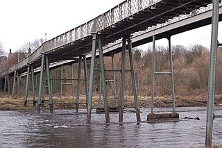
Ovingham is a civil parish and village in the Tyne Valley of south Northumberland, England. It lies on the River Tyne 10 miles (16 km) east of Hexham with neighbours Prudhoe, Ovington, Wylam and Stocksfield.

Allen Banks & Staward Gorge is National Trust property in the English county of Northumberland.
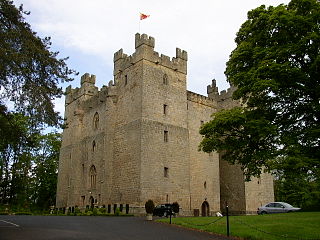
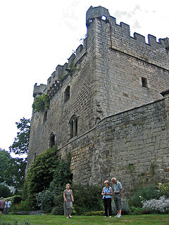
Langley Castle is a restored medieval tower house, now operated as a hotel, situated in the village of Langley in the valley of the River South Tyne some 3 miles (5 km) south of Haydon Bridge, Northumberland, England. It is a Grade I listed building.

The River Allen is a river in the English county of Northumberland. The river has its sources in the hills of the Northern Pennines, and is formed by the confluence of the East and West Allen rivers. The Allen is itself, a tributary of the River Tyne. The Allen was formerly very polluted from mining activity upstream, but remediation schemes have been implemented to allow the water quality to improve.
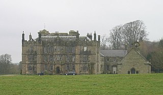
Chipchase Castle is a 17th-century Jacobean mansion incorporating a substantial 14th-century pele tower, which stands north of Hadrian's Wall, near Wark on Tyne, between Bellingham and Hexham in Northumberland, England. It is a Scheduled Ancient Monument and a Grade I listed building.

Newbrough is a village in Northumberland, England, on the north bank of the River South Tyne about 5 miles (8 km) north-west of Hexham.

Horsley is a small village in Northumberland. It is located around 11 miles (18 km) from Newcastle upon Tyne and 12 miles (19 km) from Hexham.
Slaggyford is a village in Northumberland, England about 5 miles (8 km) north of Alston, Cumbria.

