Narragansett Trail's Lantern Hill view of Lantern Hill Pond.
Name
Lantern Hill
Narragansett Trail blazes with Lantern Hill and Loop Trail signs.
The hill's white quartz cliffs are said to shine in sunlight when viewed from the Atlantic Ocean (Caulkins 1895; Crandall 1949).[1][2] Some consider the hill to be "Tar Barrel Hill," where barrels of tar were burned on August 11, 1814, to warn residents of the approach of the British during the War of 1812 (Philips 1992);[3] however, "Tar Barrel Hill" may be what is now known as "Jeremy Hill" to the southeast (Heermance 1935).[4]
Geology
The hill is composed mostly of high-purity milky quartz and it occupies the inactive Lantern Hill Fault, which runs south into the Atlantic Ocean. Analysis of the quartz reveals that it is 238 million years old—the mid-Triassic Period of the Mesozoic Era in geologic time, according to current theories. The formation of the fault and the quartz are associated with the early formation of the Atlantic Ocean (Altamura 1995; Altamura 2003).[5][6]
Land use
David D. Mallory began commercial mining of the hill's silica in 1870 (Haynes and Boylan 1976);[7] the quarry closed when the Mashantucket Pequots acquired the land in 1994. Lantern Hill is the southwestern terminus of the Narragansett Trail, a hiking path maintained in Connecticut by the Connecticut Forest and Park Association (CFPA 2005).[8] The hilltop offers views of the Atlantic Ocean and the surrounding countryside, including the Mashantucket Pequots' Lantern Hill Reservation, the Mashantucket Museum and Research Center, and the Foxwoods Resort and Casino.
Image gallery
Views from Lantern Hill
Lantern Hill Trail signs.
Narragansett Trail blazes with Lantern Hill and Loop Trail signs.
Narragansett Trail's Lantern Hill view of Lantern Hill Pond.
Narragansett Trail's Lantern Hill view of the Mashantucket Pequots Foxwoods Casino Resort.
Narragansett Trail's Lantern Hill view of hawks flying. Mashantucket Pequot Museum can be seen in the far background.
↑ Crandall, Katharine B. (1949). The Fine Old Town of Stonington: A Historical Tribute to the Founders and Their Descendants. Westerly: Utter. pp.107–108. OCLC1958744.
↑ Altamura, Robert J. (1995). "Tectonics, Wall-Rock Alteration and Emplacement History of the Lantern Hill Giant Quartz Lode, Avalonian Terrane, Southeastern Connecticut". In McHone, Nancy W. (ed.). Guidebook for Field Trips in Eastern Connecticut and the Hartford Basin. Hartford: State Geological and Natural History Survey of Connecticut. pp.E1 –E36. OCLC32554363.
↑ Connecticut Forest and Park Association (2005). Ann T. Colson; Cindi D. Pietrzyk (eds.). Connecticut Walk Book East (19thed.). Rockfall: Connecticut Forest and Park Association. pp.205–206. ISBN0-9619052-5-5. OCLC1782327.
This page is based on this Wikipedia article Text is available under the CC BY-SA 4.0 license; additional terms may apply. Images, videos and audio are available under their respective licenses.

 Lantern Hill Trail signs.
 Narragansett Trail blazes with Lantern Hill and Loop Trail signs.
 Narragansett Trail's Lantern Hill view of Lantern Hill Pond.
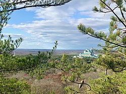 Narragansett Trail's Lantern Hill view of the Mashantucket Pequots Foxwoods Casino Resort.
 Narragansett Trail's Lantern Hill view of hawks flying. Mashantucket Pequot Museum can be seen in the far background.


