Laon-Athies Air Base

Last updated
Laon-Athies Air Base
Villeneuve-Vertus Airfield
Advanced Landing Ground (ALG) A-69
Patch9thusaaf.png
Picardy Region, France
France location map-Regions and departements-2016.svg
Red pog.svg
Laon-Athies Air Base
Coordinates 49°35′47″N003°42′31″E / 49.59639°N 3.70861°E / 49.59639; 3.70861 Coordinates: 49°35′47″N003°42′31″E / 49.59639°N 3.70861°E / 49.59639; 3.70861
TypeMilitary airfield
Site information
Controlled by Us army air corps shield.svg   United States Army Air Forces
Roundel of the USAF.svg   United States Air Force
Site history
In useSeptember 1944-May 1945. 1950s-1960s
MaterialsConcrete

Laon-Athies Air Base is an abandoned military airfield, which is located near the city of Laon in the Aisne department of France.

Contents

Its history begins before World War II, when it was originally a grass civil airdrome. During the German occupation of France (1940–1944), the Luftwaffe developed the airdrome into a major military airfield, basing a variety of planes at the airfield, as well as using it as a maintenance and supply depot. Attacked frequently by Allied Air Forces, the Luftwaffe base was seized by Allied Ground Forces in September 1944 and was used as a Fighter and bomber base by the United States Army Air Forces until the end of the war.

Closed after the war, the airfield was rebuilt in the 1950s as a NATO Dispersed Operating Base for United States Air Force units in France to disperse their forces to in case of a war with the Warsaw Pact. The base was home to the 66th Tactical Reconnaissance Wing during the 60's and was abandoned by 1967.

History

Athies appears to have been an airport prior to World War II, most likely with some hangars, a terminal, control tower and grass runways.

German use during World War II

Seized by the Germans in June 1940 during the Battle of France, Athies was used as a Luftwaffe military airfield during the occupation. The Germans improved the facility by expanding the support area with numerous maintenance shops, hangars, and laying down two 1600m concrete all-weather runways, aligned 17/35 and 08/26. Numerous taxiways and dispersal aircraft parking areas were also constructed.

Known units assigned (all from Luftlotte 3, Fliegerkorps IV): [1] [2]

In addition, from wartime USAAF records, the Luftwaffe established a maintenance repair and supply depot at Athies. The airfield was initially used as a bomber base for night bomber operations by He 111s and Ju 88s, attacking targets in England until late 1943. With Luftwaffe bomber activities ending, Athies became a night interceptor base against Royal Air Force bombers flying over Occupied France on their way to targets in Germany. It appears that SG 4, a Fw 190F/G unit, was brought to Athies from the Eastern Front, where it was a dive-bomber unit. The airfield was attacked on several occasions by Eighth Air Force heavy bombers in 1943 and 1944.

American use

A-26 Invader of the 416th Bombardment Group at A-69 Laon/Athies Airfield, 1945 416th Bombardment Group Douglas A-26 Invader 1945.jpg
A-26 Invader of the 416th Bombardment Group at A-69 Laon/Athies Airfield, 1945

During the Liberation of France, the Luftwaffe abandoned the base airfield at the end of August, sending in demolition teams to blow up hangars, buildings, electrical generators, water treatment and other facilities. It was seized by Allied ground forces in early September, and turned over to the United States Army Air Forces. The IX Engineer Command 820th Engineer Aviation Battalion moved in about 7 September and began a quick rehabilitation of the base so it could be used by American aircraft. [3]

It was declared operationally ready for combat units on 9 September, a few days after its capture from German forces, being designated as Advanced Landing Ground "A-69 Laon/Athies Airfield". Although operationally usable, Athies was a wrecked base from the Allied air attacks and what was blown up by the Germans as they withdrew. The Americans made do with what could be repaired, and moved in what equipment was necessary to conduct combat operations. Many buildings of masonry construction had been made useless, their contents consisting of nothing but wreckage. [4] [5]

Under American control, Ninth Air Force used the base for several units from 7 September 1944 until closing the base in July 1945. Known units assigned were: [6]

With each combat group having three fully equipped squadrons, the airfield at Laon-Athies became one of the busiest American bases on the continent. With the war ended, Laon/Athies airfield was closed on 23 May 1945 and turned over to the French Air Ministry.

Postwar use

In French control after the war, the base sat abandoned for several years. There was much unexploded ordnance at the site which needed to be removed, as well as the wreckage of German and American aircraft. Many of the buildings at the base were destroyed by the war, and although some had been repaired by the American combat engineers, most were in ruins. Also, the French Air Force wanted nothing to do with a Nazi airfield on French soil. As a result, the Air Ministry leased the land, concrete runways, structures and all, out to farmers for agricultural use, sending in unexploded ordnance teams to remove the dangerous munitions.

NATO use

In 1950 when as a result of the Cold War threat of the Soviet Union, the air base at Laon-Athies was offered to the United States Air Force by the French Air Ministry as part of their NATO commitment to establish a modern Air Force Base at the site. The high cost of breaking the agricultural leases, and also the high costs of removing the concrete German runways and other facilities led to its rejection as a site for a full air base. However NATO faced several problems when attempting to solve the air power survival equation. Planning for a Warsaw Pact first strike survival in both conventional and nuclear wars had to be considered. The main air bases were built on small parcels of land with very limited dispersal space. It was decided to use Laon-Athies as an emergency "backup" airfield, consisting of a "bare bones" facility of a runway with minimal facilities intended for use by all NATO air forces to disperse their aircraft in case of war.

Beginning about 1954, French demolition companies returned to Laon-Athies and began demolishing the German structures and removing the wreckage of the World War II air base. French Army Explosive demolition teams were brought in to safely remove unexploded ordnance remaining from the war and the site was prepared for construction. A modern all-weather concrete NATO jet runway was laid down aligned 02/20, with taxiways and dispersal areas for three fighter squadrons. The dispersals were designed in a circular marguerite system of hardstands which could be revetted later with earth for added aircraft protection. Typically the margueriete consisted of fifteen to eighteen hardstands, with each hardstand capable of parking one or two aircraft, allowing the planes to be spaced approximately 150 feet (50 m) apart. Each squadron was assigned to a separate hangar/hardstand complex.

Other than the occasional touch-and-go landing of NATO (USAF) aircraft, Laon-Athies Air Base was never used. With the French withdrawal from the integrated military component of NATO in 1967, the base was abandoned. [7]

Current

Laon-Athies Air Base is to the east of the A26 autoroute, near the city of Laon, northeast of the D977 interchange. Today, the former airport and military air base is used for agriculture. The NATO runway, dispersals and taxiways remain in place, and although deteriorated after 40 years of abandonment, they are most likely usable for emergency aircraft landings. All three marguerites and their dispersal pads remain, some removed, but most in reasonable condition.

The removal of the wartime base in the early 1950s was very complete. The only remaining features of Athies wartime past are the two German-built concrete runways, still largely intact. Also taxiways built by the Germans remain as single-track agricultural roads. It is suspected that many former wartime buildings and structures are in the wooded area to the southeast of the airfield, including the bomb dump, however that cannot be discerned from aerial photography due to the extensive tree canopy. Several wartime runways can be seen in the wooded area, probably leading to dispersals, revetments and other abandoned concrete structures.

Heavy equipment flattening whole remaining of former airfield and dispersal marguerites to allow installation of solar panels.

Whole former airbase ground surface and runways to be used as solar farm in the future.

See also

Related Research Articles

<span class="mw-page-title-main">Beauvais–Tillé Airport</span> International airport serving Beauvais, France

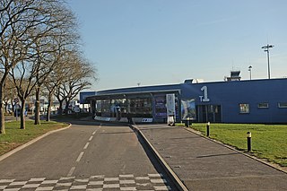
Beauvais–Tillé Airport, branded as Paris-Beauvais Airport, is an international airport near the city of Beauvais in the commune of Tillé in France. In 2016, it was the tenth busiest airport in France, handling 3,997,856 passengers, and is mostly used by charter and low-cost airlines.

<span class="mw-page-title-main">Quartier Mangin</span> Airport

Laon-Couvron Air Base is a former French and United States Air Force base in France. It is located in the Aisne département of France, less than one mile southeast of the village of Couvron and 6 miles northwest of Laon; on the southwest side of the Autoroute des Anglais 1 Mile (1.6 km) east of the village of Couvron-et-Aumencourt.

<span class="mw-page-title-main">Chièvres Air Base</span>

Chièvres Air Base, also referred to as SHAPE Airfield at Chievres Air Base, is a NATO airfield operated by the United States Air Force. It is located 1 nautical mile east southeast of the Walloon town of Chièvres in the province of Hainaut, Belgium and about 12 mi (19 km) from Headquarters, Supreme Headquarters Allied Powers Europe (SHAPE), in Casteau. It is mainly used to provide logistic support to NATO and SHAPE. Infrastructure support is provided by the United States Army Garrison Benelux for NATO.

Saint-Dizier-Robinson Air Base is a front-line French Air and Space Force fighter aircraft base located approximately 4 km west of Saint-Dizier, in the Haute-Marne department of the Champagne-Ardenne region in northeastern France.

<span class="mw-page-title-main">Saint-Simon – Clastres Air Base</span>

Saint-Simon – Clastres Air Base is an abandoned military airfield, which is located approximately 3 km (2 NM) northwest of Clastres and east of Saint-Simon, both communes in the Aisne department of the Picardy (Picardie) region in France. It is approximately 116 km (63 NM) north-northeast of Paris.

<span class="mw-page-title-main">Chartres – Champhol Aerodrome</span> Airport

Chartres – Champhol Aerodrome is an airport serving Chartres and Champhol, in the Eure-et-Loir department in north-central France. The airport is located 2.5 km (1.3 NM) east-northeast of Chartres and it is southeast of Champhol. It supports general aviation with no commercial airline service scheduled.

Châteaudun Air Base was a French Air Force (French: Armée de l'Air base, between 1934 and 2014. The base was located approximately 3.5 kilometres southeast of Châteaudun and about 112 kilometres southwest of Paris. It is currently an airfield attached to Orléans – Bricy Air Base.

<span class="mw-page-title-main">Brétigny-sur-Orge Air Base</span> Airport in Brétigny, France

Brétigny-sur-Orge Air Base is a former French Air Force French: Armée de l'Air (ALA) base. The base is located approximately 2 miles (3.2 km) southeast of Brétigny-sur-Orge; about 17 miles (27 km) south of Paris.

<span class="mw-page-title-main">Orléans – Bricy Air Base</span> Airport in Orléans, France

Orléans – Bricy Air Base is a French Air and Space Force (ALAE) base. The base is located approximately 6 miles (9.7 km) north-northwesst of Ingré near the city of Orléans; about 65 miles (105 km) south-southwest of Paris, France.

Vitry-en-Artois Airfield is a regional airfield in France, located 1 mile (1.6 km) northeast of Vitry-en-Artois; 105 miles (169 km) north-northeast of Paris. It supports general aviation with no commercial airline service scheduled.

Juvincourt Airfield is an abandoned military airfield, which is located near the commune of Juvincourt-et-Damary in the Aisne department of northern France.

Melun Villaroche Aerodrome is an aerodrome located 8.5 km (4.6 NM) north of Melun, a commune in the Seine-et-Marne department in the Île-de-France region in north-central France.

Coulommiers – Voisins Aerodrome is an airport serving Coulommiers in France. It is located in the Seine-et-Marne department, 5 km (2.7 NM) west-northwest of Coulommiers. It is also 34 miles (55 km) east of Paris.

<span class="mw-page-title-main">Pontoise – Cormeilles Aerodrome</span> Airport in Boissy lAillerie, France

Pontoise Aerodrome or Pontoise – Cormeilles Aerodrome is an airport located 7 km (3.8 NM) northwest of Pontoise in Boissy l'Aillerie near Cormeilles-en-Vexin, all communes of the Val-d'Oise department in the Île-de-France region in northern France. The airport is also located 16 miles (26 km) northwest of Paris.

<span class="mw-page-title-main">Peronne-St Quentin Airfield</span> Airport in Estress Mons, France

Péronne-St Quentin Airfield is a recreational aerodrome in France, located 11 miles (18 km) west of Saint-Quentin; 121 miles (195 km) north of Paris. It supports general aviation with no commercial airline service scheduled.

<span class="mw-page-title-main">Cambrai-Niergnies Airport</span> Airport in Cambrai, France

Cambrai-Niergnies Airport is a regional airport in France, located 3 miles (4.8 km) south-southeast of Cambrai; 100 miles (160 km) north-northeast of Paris.

Giebelstadt Army Airfield is a closed military airfield located in Germany, southwest of Giebelstadt in Bavaria, approximately 250 miles southwest of Berlin. It was turned over to the German government on 23 June 2006 and is now Giebelstadt Airport, a general aviation airport.

Münster-Handorf Airfield is a former military airfield located in Germany about 5 miles east-northeast of Münster (Nordrhein-Westfalen); approximately 250 miles west of Berlin.

Saint-André-de-l'Eure Airfield is a recreational aerodrome in France, located about 10 miles southwest of Évreux (Normandy). It supports general aviation with no commercial airline service scheduled.

<span class="mw-page-title-main">Celone/San Nicola d'Arpi Airfield</span>

Celone/San Nicola d'Arpi Airfield is an abandoned World War II military airfield in Italy. It was located 10 kilometers north of Foggia, in the Province of Foggia. The airfield was abandoned and dismantled after the end of the war in 1945.

References

PD-icon.svg This article incorporates public domain material from the Air Force Historical Research Agency.

  1. The Luftwaffe, 1933-45
  2. Identification codes of units of the Luftwaffe 1939 - 1945
  3. IX Engineer Command ETO Airfields, Airfield Layout
  4. IX Engineering Command Advanced Landing Grounds
  5. Johnson, David C. (1988), U.S. Army Air Forces Continental Airfields (ETO), D-Day to V-E Day; Research Division, USAF Historical Research Center, Maxwell AFB, Alabama.
  6. Maurer, Maurer. Air Force Combat Units of World War II. Maxwell AFB, Alabama: Office of Air Force History, 1983. ISBN   0-89201-092-4.
  7. McAuliffe, Jerome J (2005): U.S. Air Force in France 1950-1967, Chapter 17, Dispersed Operating Bases