
Kinghorn is a town and parish in Fife, Scotland. A seaside resort with two beaches, Kinghorn Beach and Pettycur Bay, plus a fishing port, it stands on the north shore of the Firth of Forth, opposite Edinburgh.
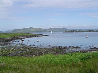
Luing is one of the Slate Islands, Firth of Lorn, in the west of Argyll in Scotland, about 16 miles (26 km) south of Oban. The island has an area of 1,430 hectares and is bounded by several small skerries and islets. It has a population of around 200 people, mostly living in Cullipool, Toberonochy, and Blackmillbay.

Gairsay is a small island in Orkney, Scotland, located in the parish of Rendall, 1.5 miles (2.4 km) off the coast, astride one of the approaches to the bays of Firth and Kirkwall. It is about 2 miles (3.2 km) long and 1 mile (1.6 km) wide and includes one conical hill and a small harbour called Millburn Bay, which is sheltered by the peninsula known as the Hen of Gairsay.
Levenmouth is a conurbation comprising a network of settlements on the north side of the Firth of Forth, in Fife on the east coast of Scotland. It consists of three principal coastal towns; Leven, Buckhaven, and Methil, and a number of villages and hamlets inland. The industrial towns of Buckhaven and Methil lie on the west bank of the River Leven, and the resort town of Leven is on the east bank. The "Bawbee Bridge" links the two sides of the river. Historically, Buckhaven and Methil were joined together as one burgh, while Leven was separate. The area had an estimated population of 37,238 in 2006.

Glen Shee is a glen in eastern Perthshire, Scotland. Shee Water flows through the glen. The head of the glen, where Gleann Taitneach and Glen Lochsie meet, is approximately 2 km north-west of the Spittal of Glenshee; it then runs south-east to Bridge of Cally where it merges with Strathardle to form Glen Ericht. Once known as the glen of the fairies it takes its name from the Gaelic "sith" meaning fairy and the old meeting place at the standing stone behind the present day church is called Dun Shith or Hill of the Fairies.

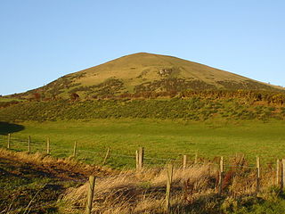
West Lomond is the highest point in the county of Fife, Scotland and the highest peak in the Lomond Hills. Its cone-shaped summit, which is the remains of a volcanic plug, rises above an escarpment of Carboniferous sandstone and limestone layers, capped with a quartz-microgabbro sill. The conspicuous peaks of West Lomond, and its neighbour East Lomond, are visible for many miles around, which explains one suggested origin of their name, the 'Lomond' or 'beacon' hills. On the summit are the remains of an Iron Age hill fort.

The Burn of Ayreland is a northwesterly flowing coastal stream on Mainland Orkney, Scotland.It discharges to the Clestrain Sound about two miles south of Stenness. Draining chiefly agricultural lands elevated mosses and moorland. This stream has a notable lack of turbidity and a pH level of approximately 8. Armouring of the stream bottom consists of pebbles, cobbles and occasional boulders.
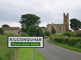
Kilconquhar is a village and parish in Fife in Scotland. It includes the small hamlet of Barnyards. It is bounded by the parishes of Elie, Ceres, Cameron, St Monans, Carnbee, Newburn and Largo. It is approximately 9 miles from north to south. Much of the land is agricultural or wooded. The village itself is situated inland, north of Kilconquhar Loch. Also in the civil parish are Colinsburgh and Largoward, the latter since 1860 being a separate ecclesiastical parish.
Newburn is a civil parish in the County of Fife in Scotland. It is located on the north coast of the Firth of Forth and bounded by the parishes of Kilconquhar and Largo. It was originally a rural parish with no major settlement, but with the development of Leven as a seaside resort in the late 19th century, the population of the parish grew considerably.
Oldany Island is an uninhabited island in Assynt, Sutherland, north-west Scotland.

Jamestown is a hamlet in Fife, Scotland, on the south side of Inverkeithing's Inner Bay. The nearby Jamestown Viaduct carries the Fife Circle Line over the hamlet, and the M90 passes by to the west.
Thornyhive Bay is an embayment along the North Sea coast in Aberdeenshire, Scotland. This bay is situated approximately 2.5 miles south of the town of Stonehaven and approximately 2.5 miles north of the Fowlsheugh Nature Reserve. The steep cliffs afford sightings of certain seabirds.
Wellwood is a small village to the north of Dunfermline, Fife, Scotland. It was named after the Wellwoods who used to own coalmines in the area. It has a leisure centre and a golf course (Canmore). It is nearby the Town Loch and also is partially bordered by Queen Anne High School. It was formerly known as Hawkiesfauld.
Stonehaven Bay is a natural harbour in Aberdeenshire, Scotland. The town of Stonehaven is built along the shore of Stonehaven Bay. The mouths of the Carron Water and the Cowie Water are both situated in Stonehaven, within the Bay.

Hillend is a small village in Fife, Scotland, to the east of Inverkeithing and to the west of Dalgety Bay.

Lumphinnans is a small, former mining village along the B981 road, from west to east between the towns of Cowdenbeath and Lochgelly, in central Fife.
Largo is a parish in Fife, Scotland containing the villages of Upper Largo or Kirkton of Largo, Lower Largo and Lundin Links. It is bounded on the west by the parish of Scoonie, on the north by Ceres and on the east by the parishes of Newburn and Kilconquhar. It has a coastline of 2¾ miles along Largo bay. Inland it extends 3-4 ½ miles north from the south coast of Fife. Area 7,378 acres.

Largoward is a village in East Fife, Scotland, lying on the road from Leven to St Andrews in the Riggin o Fife, 4½ miles north-east of Lower Largo and 6½ miles south-west of St Andrews. It is an agricultural and former mining village, one of the three main villages of the civil parish of Kilconquhar, along with Colinsburgh and the village of Kilconquhar. Coal must have been worked for a considerable length of time in the district, as it is recorded that coal was driven annually from Falfield, just north-west of the village, to Falkland Palace for the use of King James VI.
