
Laurens County is a county located in the central part of the U.S. state of Georgia. As of the 2020 census, the population was 49,570, up from 48,434 in 2010. The county seat is Dublin. The county was founded on December 10, 1807, and named after Lieutenant Colonel John Laurens, an American soldier and statesman from South Carolina during the American Revolutionary War.
Druid Hills is a community which includes both a census-designated place (CDP) in unincorporated DeKalb County, Georgia, United States, as well as a neighborhood of the city of Atlanta. The CDP's population was 14,568 at the 2010 census. The CDP formerly contained the main campus of Emory University and the Centers for Disease Control and Prevention (CDC) however they were annexed by Atlanta in 2018. The Atlanta-city section of Druid Hills is one of Atlanta's most affluent neighborhoods with a mean household income in excess of $238,500.

The city of Blackshear is the county seat of Pierce County, Georgia, United States. As of the 2020 census, the city had a population of 3,506.

Penfield, Georgia, United States was established shortly after 1829 in Greene County, and named in honor of Josiah Penfield, a Savannah merchant and silversmith, who bequeathed $2,500.00 and a financial challenge to the Georgia Baptist Convention to match his gift for educational purposes. The convention, led by Billington Sanders, organized a manual labor school which opened in 1833 as Mercer Institute, in honor of Rev. Jesse Mercer of Greene County, a major contributor to the matching gift request.
Budapest is a small unincorporated community in Haralson County in the U.S. state of Georgia. It is located at an elevation of 1,362 feet (415 m). Budapest is located] on U.S. Route 78, about five miles (8 km) southeast of Tallapoosa.
There were several historic mills around the metro Atlanta area, for which many of its current-day roads are still named. Most of the mills date back to the 1820s and 1830s, and were built along the area's many streams. The locations of many of these mills are shown on a map of 1875 showing U. S. military operations around Atlanta in 1864. This map is now located in the U. S. Library of Congress but can be seen on the webpage linked here.
Historic ferries operated on rivers around Atlanta, Georgia area, and became namesakes for numerous current-day roads in north Georgia. Most of the ferries date to the early years of European-American settlement in the 1820s and 1830s, when parts of the region were still occupied by cherokee and other Native American communities.
The Dublin and Southwestern Railroad was founded in 1904 and began operating in 1905. Originally planned to operate between Dublin, GA and Abbeville, GA, it never got further than Eastman, GA. In 1907, the Wrightsville and Tennille Railroad acquired the property of the D&S. The ex-D&S was abandoned in 1941.

Lamington is an unincorporated community and census-designated place (CDP) located within Bedminster Township in Somerset County, in the U.S. state of New Jersey. It contains the Lamington Presbyterian Church Cemetery and the Lamington Black Cemetery.
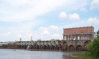
Lake Blackshear is a man-made lake on the Flint River in Georgia created by a dam that was constructed from 1925 to 1930. The lake was named after General David Blackshear.

Lauderdale is an unincorporated community and census-designated place (CDP) in Lauderdale County, Mississippi, United States. It is situated along U.S. Highway 45, 16 miles (26 km) northeast of Meridian, the county seat. The population of Lauderdale was 395 at the 2020 census.
Paces is a neighborhood of Atlanta, US. It is part of the Buckhead district and located in the far northwest corner of the city. Paces is bounded on the northwest by the Chattahoochee River, which is also the Cobb/Fulton county line. Just across the river in Cobb is the unincorporated community of Vinings, which was originally known as Paces after founder Hardy Pace, who operated Pace's Ferry. Cumberland is also located on the other side of the river. It is perhaps Atlanta's most affluent neighborhood, with many houses selling in the US$5–$7 million range, and some for more than $20 million.
David Blackshear was an American general. Lake Blackshear, Blackshear Road and the city of Blackshear, Georgia, were named in honor him. He authorized road and bridge construction in the area and some 11 forts for defense. He fought in the American Revolution, possibly in the Craven County Regiment of the North Carolina militia. He was reported to have been engaged at the Battle of Moore's Creek Bridge on February 27, 1776 and the Battle of Beaufort in April 1782.
Whitesville is an unincorporated community in Harris County, Georgia, United States.
Nameless is an unincorporated community in Laurens County, in the U.S. state of Georgia.
Mars Hill Crossroads is an unincorporated community in Dooly County, in the U.S. state of Georgia.
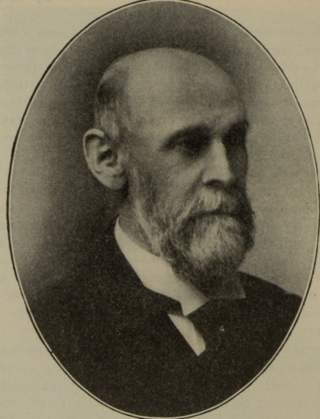
Alexander Campbell Bruce (1835–1927), also known as A. C. Bruce, was an American architect based in Atlanta, Georgia.


