Gallery
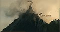 A spire of lava on top of the lava dome of Soufrière Hills volcano
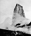 A lava spine at the summit of Mount Pelée in 1902
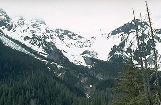
 "Whaleback", Mount St. Helens
A lava spine (or lava spire) is a vertical growth of solid lava that is forced from a volcanic vent. A lava spine can either be formed by viscous lava slowly being pushed out of the vent, or by magma that has solidified within the vent before being pushed out. [1]
In February 1983, the dome activity of Mount St. Helens culminated in a spine that reached a height of about 30 metres (100 ft) before collapsing after two weeks, but in 2005 another lava spine (called the Whaleback) lasted until it collapsed in July 2005. In November 2005, a new spine, called "the slab" grew continuously until late 2006, though it continually collapsed under its own weight; the growth finally stopped in January 2008, when Mount St. Helens' eruption ended. Another example is a spine that appeared on the lava dome of the Soufrière Hills Volcano in Montserrat prior to the volcano's eruption in 1997. [2]


A volcano is a rupture in the crust of a planetary-mass object, such as Earth, that allows hot lava, volcanic ash, and gases to escape from a magma chamber below the surface.

Mount St. Helens is an active stratovolcano located in Skamania County, Washington, in the Pacific Northwest region of the United States. It lies 52 miles (83 km) northeast of Portland, Oregon, and 98 miles (158 km) south of Seattle. Mount St. Helens takes its English name from that of the British diplomat Lord St Helens, a friend of explorer George Vancouver who surveyed the area in the late 18th century. The volcano is part of the Cascade Volcanic Arc, a segment of the Pacific Ring of Fire.

A stratovolcano, also known as a composite volcano, is a conical volcano built up by many layers (strata) of hardened lava and tephra. Unlike shield volcanoes, stratovolcanoes are characterized by a steep profile with a summit crater and periodic intervals of explosive eruptions and effusive eruptions, although some have collapsed summit craters called calderas. The lava flowing from stratovolcanoes typically cools and hardens before spreading far, due to high viscosity. The magma forming this lava is often felsic, having high to intermediate levels of silica, with lesser amounts of less viscous mafic magma. Extensive felsic lava flows are uncommon, but have travelled as far as 15 km (9 mi).

A pyroclastic flow is a fast-moving current of hot gas and volcanic matter that flows along the ground away from a volcano at average speeds of 100 km/h (30 m/s)(~62 mph) but is capable of reaching speeds up to 700 km/h (190 m/s)(~435 mph). The gases and tephra can reach temperatures of about 1,000 °C (1,800 °F).

Mount Pelée or Mont Pelée is an active volcano at the northern end of Martinique, an island and French overseas department in the Lesser Antilles Volcanic Arc of the Caribbean. Its volcanic cone is composed of stratified layers of hardened ash and solidified lava. Its most recent eruption was in 1932.

Lassen Volcanic National Park is an American national park in northeastern California. The dominant feature of the park is Lassen Peak, the largest plug dome volcano in the world and the southernmost volcano in the Cascade Range. Lassen Volcanic National Park is one of the few areas in the world where all four types of volcano can be found—plug dome, shield, cinder cone, and stratovolcano.

The Lassen volcanic area presents a geological record of sedimentation and volcanic activity in and around Lassen Volcanic National Park in Northern California, U.S. The park is located in the southernmost part of the Cascade Mountain Range in the Pacific Northwest region of the United States. Pacific Oceanic tectonic plates have plunged below the North American Plate in this part of North America for hundreds of millions of years. Heat and molten rock from these subducting plates has fed scores of volcanoes in California, Oregon, Washington and British Columbia over at least the past 30 million years, including these in the Lassen volcanic areas.

Lassen Peak, commonly referred to as Mount Lassen, is a lava dome volcano and the southernmost active volcano in the Cascade Range of the Western United States. Located in the Shasta Cascade region of Northern California, it is part of the Cascade Volcanic Arc, which stretches from southwestern British Columbia to northern California. Lassen Peak reaches an elevation of 10,457 ft (3,187 m), standing above the northern Sacramento Valley. It supports many flora and fauna among its diverse habitats, which are subject to frequent snowfall and reach high elevations.

The Soufrière Hills are an active, complex stratovolcano with many lava domes forming its summit on the Caribbean island of Montserrat. After a long period of dormancy, the Soufrière Hills volcano became active in 1995 and has continued to erupt ever since. Its eruptions have rendered more than half of Montserrat uninhabitable, destroying the capital city, Plymouth, and causing widespread evacuations: about two-thirds of the population have left the island. Chances Peak in the Soufrière Hills was the highest summit on Montserrat until the mid-1990s, but it has since been eclipsed by various rising and falling volcanic domes during the recent volcanic activity.

The Garibaldi Volcanic Belt is a northwest–southeast trending volcanic chain in the Pacific Ranges of the Coast Mountains that extends from Watts Point in the south to the Ha-Iltzuk Icefield in the north. This chain of volcanoes is located in southwestern British Columbia, Canada. It forms the northernmost segment of the Cascade Volcanic Arc, which includes Mount St. Helens and Mount Baker. Most volcanoes of the Garibaldi chain are dormant stratovolcanoes and subglacial volcanoes that have been eroded by glacial ice. Less common volcanic landforms include cinder cones, volcanic plugs, lava domes and calderas. These diverse formations were created by different styles of volcanic activity, including Peléan and Plinian eruptions.

The 2004–2008 volcanic activity of Mount St. Helens in Washington, United States has been documented as a continuous eruption in the form of gradual extrusion of magma. Starting in October 2004 and ceasing in January 2008, a new lava dome was built up. The new dome did not rise above the rim of the crater created by the 1980 eruption of Mount St. Helens.

In volcanology, a lava dome is a circular, mound-shaped protrusion resulting from the slow extrusion of viscous lava from a volcano. Dome-building eruptions are common, particularly in convergent plate boundary settings. Around 6% of eruptions on Earth are lava dome forming. The geochemistry of lava domes can vary from basalt to rhyolite although the majority are of intermediate composition The characteristic dome shape is attributed to high viscosity that prevents the lava from flowing very far. This high viscosity can be obtained in two ways: by high levels of silica in the magma, or by degassing of fluid magma. Since viscous basaltic and andesitic domes weather fast and easily break apart by further input of fluid lava, most of the preserved domes have high silica content and consist of rhyolite or dacite.

La Soufrière or Soufrière Saint Vincent is an active stratovolcano on the Caribbean island of Saint Vincent in Saint Vincent and the Grenadines. It is the highest peak in Saint Vincent, and has had five recorded explosive eruptions since 1718. The latest eruptive activity began on 27 December 2020 with the slow extrusion of a dome of lava, and culminated in a series of explosive events between 9 and 22 April 2021.

Peléan eruptions are a type of volcanic eruption. They can occur when viscous magma, typically of rhyolitic or andesitic type, is involved, and share some similarities with Vulcanian eruptions. The most important characteristic of a Peléan eruption is the presence of a glowing avalanche of hot volcanic ash, called a pyroclastic flow. Formation of lava domes is another characteristic. Short flows of ash or creation of pumice cones may be observed as well.

Several types of volcanic eruptions—during which lava, tephra, and assorted gases are expelled from a volcanic vent or fissure—have been distinguished by volcanologists. These are often named after famous volcanoes where that type of behavior has been observed. Some volcanoes may exhibit only one characteristic type of eruption during a period of activity, while others may display an entire sequence of types all in one eruptive series.

The Crater Glacier is a geologically young glacier that is located on Mount St. Helens, in the U.S. state of Washington. The glacier formed after the 1980 Eruption and due to its location, the body of ice grew rapidly, unknown to the public for nearly 20 years. The glacier once contained ice caves in the smooth ice before the 2004–2008 volcanic activity. The growth of the lava dome and volcanic eruptions from 2004 to 2008 significantly altered the appearance of the glacier. In the same time period, several agencies decided to put an official name on the glacier which, at first, was Tulutson Glacier. A later decision made Crater Glacier the official glacier name. Despite the volcanic activity, the glacier continued to advance and by mid-2008, the glacier completely encircled the lava domes. In addition, new glaciers have formed around Crater Glacier as well.

The Mount Edziza volcanic complex is a large and potentially active north-south trending complex volcano in Stikine Country, northwestern British Columbia, Canada, located 38 kilometres (24 mi) southeast of the small community of Telegraph Creek. It occupies the southeastern portion of the Tahltan Highland, an upland area of plateau and lower mountain ranges, lying east of the Boundary Ranges and south of the Inklin River, which is the east fork of the Taku River. As a volcanic complex, it consists of many types of volcanoes, including shield volcanoes, calderas, lava domes, stratovolcanoes, and cinder cones.

The Mount Cayley volcanic field (MCVF) is a remote volcanic zone on the South Coast of British Columbia, Canada, stretching 31 km (19 mi) from the Pemberton Icefield to the Squamish River. It forms a segment of the Garibaldi Volcanic Belt, the Canadian portion of the Cascade Volcanic Arc, which extends from Northern California to southwestern British Columbia. Most of the MCVF volcanoes were formed during periods of volcanism under sheets of glacial ice throughout the last glacial period. These subglacial eruptions formed steep, flat-topped volcanoes and subglacial lava domes, most of which have been entirely exposed by deglaciation. However, at least two volcanoes predate the last glacial period and both are highly eroded. The field gets its name from Mount Cayley, a volcanic peak located at the southern end of the Powder Mountain Icefield. This icefield covers much of the central portion of the volcanic field and is one of the several glacial fields in the Pacific Ranges of the Coast Mountains.
The Bridge River Vent is a volcanic crater in the Pacific Ranges of the Coast Mountains in southwestern British Columbia, Canada. It is located 51 km (32 mi) west of Bralorne on the northeastern flank of the Mount Meager massif. With an elevation of 1,524 m (5,000 ft), it lies on the steep northern face of Plinth Peak, a 2,677 m (8,783 ft) high volcanic peak comprising the northern portion of Meager. The vent rises above the western shoulder of the Pemberton Valley and represents the northernmost volcanic feature of the Mount Meager massif.

Barry Voight is an American geologist, volcanologist, author, and engineer. After earning his Ph.D. at Columbia University, Voight worked as a professor of geology at several universities, including Pennsylvania State University, where he taught from 1964 until his retirement in 2005. He remains an emeritus professor there and still conducts research, focusing on rock mechanics, plate tectonics, disaster prevention, and geotechnical engineering.
| | This volcanology article is a stub. You can help Wikipedia by expanding it. |