Lavina, Montana

Last updated

Lavina, Montana
Golden Valley County Montana Incorporated and Unincorporated areas Lavina Highlighted.svg
Location of Lavina, Montana
Coordinates: 46°17′42″N108°56′23″W / 46.29500°N 108.93972°W / 46.29500; -108.93972
Country United States
State Montana
County Golden Valley
Area
[1]
  Total1.01 sq mi (2.62 km2)
  Land1.01 sq mi (2.62 km2)
  Water0.00 sq mi (0.00 km2)
Elevation
3,448 ft (1,051 m)
Population
 (2020)
  Total136
  Density134.52/sq mi (51.93/km2)
Time zone UTC-7 (Mountain (MST))
  Summer (DST) UTC-6 (MDT)
ZIP code
59046
Area code 406
FIPS code 30-42850
GNIS feature ID0773260

Lavina is a town in Golden Valley County, Montana, United States. The population was 136 at the 2020 census. [2] The town is situated on the north bank of the Musselshell River.

Contents

The town became a stage stop in 1882. The town incorporated in 1920. [3]

Geography

Lavina is located at 46°17′42″N108°56′23″W / 46.29500°N 108.93972°W / 46.29500; -108.93972 (46.295130, -108.939684). [4] Montana Highway 3 intersects with U.S. Route 12 at the town.

According to the United States Census Bureau, the town has a total area of 1.00 square mile (2.59 km2), all land. [5]

Climate

This climatic region is typified by large seasonal temperature differences, with warm to hot (and often humid) summers and cold (sometimes severely cold) winters. According to the Köppen Climate Classification system, Lavina has a humid continental climate, abbreviated "Dfb" on climate maps. [6]

Demographics

Historical population
CensusPop.Note
1930 148
1940 19934.5%
1950 195−2.0%
1960 2128.7%
1970 169−20.3%
1980 164−3.0%
1990 151−7.9%
2000 20938.4%
2010 187−10.5%
2020 136−27.3%
U.S. Decennial Census [7] [2]

2010 census

As of the census [8] of 2010, there were 187 people, 79 households, and 52 families residing in the town. The population density was 187.0 inhabitants per square mile (72.2/km2). There were 91 housing units at an average density of 91.0 per square mile (35.1/km2). The racial makeup of the town was 89.3% White, 0.5% Native American, 1.6% Asian, 3.7% from other races, and 4.8% from two or more races. Hispanic or Latino of any race were 3.7% of the population.

There were 79 households, of which 26.6% had children under the age of 18 living with them, 50.6% were married couples living together, 7.6% had a female householder with no husband present, 7.6% had a male householder with no wife present, and 34.2% were non-families. 32.9% of all households were made up of individuals, and 11.4% had someone living alone who was 65 years of age or older. The average household size was 2.37 and the average family size was 3.00.

The median age in the town was 44.5 years. 25.7% of residents were under the age of 18; 7.5% were between the ages of 18 and 24; 17.6% were from 25 to 44; 33.2% were from 45 to 64; and 16% were 65 years of age or older. The gender makeup of the town was 51.3% male and 48.7% female.

2000 census

As of the census [9] of 2000, there were 209 people, 85 households, and 57 families residing in the town. The population density was 206.9 inhabitants per square mile (79.9/km2). There were 98 housing units at an average density of 97.0 per square mile (37.5/km2). The racial makeup of the town was 98.56% White, 0.48% Asian, and 0.96% from two or more races. Hispanic or Latino of any race were 3.35% of the population.

There were 85 households, out of which 29.4% had children under the age of 18 living with them, 57.6% were married couples living together, 5.9% had a female householder with no husband present, and 32.9% were non-families. 28.2% of all households were made up of individuals, and 11.8% had someone living alone who was 65 years of age or older. The average household size was 2.46 and the average family size was 2.96.

In the town, the population was spread out, with 26.8% under the age of 18, 5.3% from 18 to 24, 23.4% from 25 to 44, 33.0% from 45 to 64, and 11.5% who were 65 years of age or older. The median age was 43 years. For every 100 females there were 90.0 males. For every 100 females age 18 and over, there were 96.2 males.

The median income for a household in the town was $24,643, and the median income for a family was $28,750. Males had a median income of $36,250 versus $23,750 for females. The per capita income for the town was $12,475. About 17.6% of families and 20.4% of the population were below the poverty line, including 21.0% of those under the age of eighteen and 20.7% of those 65 or over.

Historic sites

Lavina contains three sites on the National Register of Historic Places: the Adams Hotel, the Lavina State Bank building, and the Slayton Mercantile Co. building. [10]

Education

Lavina Public Schools educates students from kindergarten through 12th grade. [11] Lavina High School is a Class C school [12] (fewer than 108 students) which helps determine athletic competitions. They are known as the Pirates.

Related Research Articles

<span class="mw-page-title-main">Golden Valley County, Montana</span> County in Montana, United States

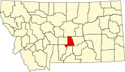
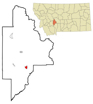
Golden Valley County is a county located in the U.S. state of Montana. As of the 2020 census, the population was 823, making it the third-least populous county in Montana. Its county seat is Ryegate.

<span class="mw-page-title-main">East Hope, Idaho</span> City in Idaho, United States

East Hope is a city in Bonner County, Idaho, United States. The population was 210 at the 2010 census.

<span class="mw-page-title-main">Weippe, Idaho</span> City in Idaho, United States

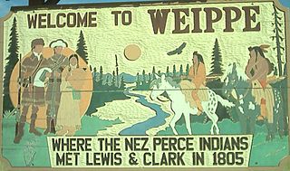
Weippe is a city in Clearwater County, Idaho, United States. The population was 441 at the 2010 census, up from 411 in 2000. In September 1805, the starving Lewis and Clark Expedition first met the Nez Perce on the Weippe Prairie, south of the city.

<span class="mw-page-title-main">Ringsted, Iowa</span> City in Iowa, United States

Ringsted is a city in Emmet County, Iowa, United States. At the 2020 census, the population was 365.

<span class="mw-page-title-main">La Motte, Iowa</span> City in Iowa, United States

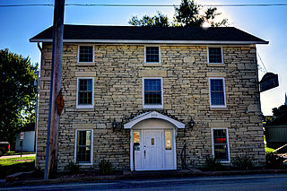
La Motte is a small city in northern Jackson County, Iowa, United States. The population was 237 at the time of the 2020 census.

<span class="mw-page-title-main">New Canada, Maine</span> Town in the state of Maine, United States

New Canada is a town in Aroostook County, Maine, United States. The population was 310 at the 2020 census.

<span class="mw-page-title-main">Minnetonka Beach, Minnesota</span> City in Minnesota, United States

Minnetonka Beach is a community in Hennepin County, Minnesota, United States. The population was 539 at the 2010 census.

<span class="mw-page-title-main">Toston, Montana</span> Census-designated place in Montana, United States

Toston is a census-designated place (CDP) in Broadwater County, Montana, United States. The population was 108 at the 2010 census.

<span class="mw-page-title-main">Fromberg, Montana</span> Town in Carbon County, Montana, United States

Fromberg is a town in Carbon County, Montana, United States. As of the 2020 census, the population of the town was 392.

<span class="mw-page-title-main">Ismay, Montana</span> Town in Montana, United States

Ismay is a town in Custer County, Montana, United States. There is a post office at Ismay, and a church, and no other businesses or services. The population was 17 at the 2020 census. The town is the least-populous incorporated municipality in the state of Montana.

<span class="mw-page-title-main">Grass Range, Montana</span> Town in Montana, United States

Grass Range is a town in Fergus County, Montana, United States. The population was 110 in both the 2010 census and 2020 census.

<span class="mw-page-title-main">Moore, Montana</span> Town in Montana, United States

Moore is a town in Fergus County, Montana, United States. The population was 194 at the 2020 census.

<span class="mw-page-title-main">Winifred, Montana</span> Town in Montana, United States

Winifred is a small town in rural north-central Fergus County, Montana, United States. It was founded in 1913 and provides services for its region's populace. The town population was 172 at the 2020 census. The current mayor is Travis Willson.

<span class="mw-page-title-main">Ryegate, Montana</span> Town in Montana, United States

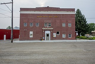
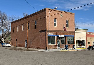
Ryegate is a town in, and the county seat of, Golden Valley County, Montana, United States. The population was 223 at the 2020 census. Ryegate is situated on the north bank of the Musselshell River.

<span class="mw-page-title-main">Drummond, Montana</span> Town in Montana, United States

Drummond is a town in Granite County, Montana, United States. The population was 272 at the 2020 census.

<span class="mw-page-title-main">Roundup, Montana</span> City in Montana, United States

Roundup is a city in and the county seat of Musselshell County, Montana, United States. The population was 1,742 during the 2020 census.

<span class="mw-page-title-main">Dixon, Montana</span> CDP in Montana, United States

Dixon is a census-designated place (CDP) in Sanders County, Montana, United States. The population was 221 at the 2020 census.

<span class="mw-page-title-main">Nashua, Montana</span> Town in Montana, United States

Nashua is a town in Valley County, Montana, United States. The population was 301 at the 2020 census.

<span class="mw-page-title-main">Broadview, Montana</span> Town in Montana, United States

Broadview is a town in Yellowstone County, Montana, United States. The population was 139 at the 2020 census.

<span class="mw-page-title-main">Hobson, Montana</span> City in Montana, United States

Hobson is a city in Judith Basin County, Montana, United States. The population was 179 at the 2020 census.

References

  1. "ArcGIS REST Services Directory". United States Census Bureau. Retrieved September 5, 2022.
  2. 1 2 "U.S. Census website". United States Census Bureau . Retrieved November 2, 2021.
  3. "Lavina". Montana Place Names Companion. Montana Historical Society. Retrieved April 5, 2021.
  4. "US Gazetteer files: 2010, 2000, and 1990". United States Census Bureau. February 12, 2011. Retrieved April 23, 2011.
  5. "US Gazetteer files 2010". United States Census Bureau. Archived from the original on July 2, 2012. Retrieved December 18, 2012.
  6. Climate Summary for Lavina, Montana
  7. "Census of Population and Housing". Census.gov. Retrieved June 4, 2015.
  8. "U.S. Census website". United States Census Bureau . Retrieved December 18, 2012.
  9. "U.S. Census website". United States Census Bureau . Retrieved January 31, 2008.
  10. National Park Service. "National Register of Historic Places Program: Research".
  11. "Lavina Public Schools". Lavina Public Schools. Retrieved April 17, 2021.
  12. "Member Schools". Montana High School Association. Retrieved April 19, 2021.