
Wangdue Phodrang District is a Thromde and dzongkhag (district) of central Bhutan. This is also the name of the dzong which dominates the district. The name is said to have been given by the Shabdrung Ngawang Namgyal who was searching for the best location for a dzong to prevent incursions from the south. The word "wangdue" means unification of Country, and "Phodrang" means Palace in Dzongkha.

Haa District is one of the 20 dzongkhag or districts comprising Bhutan. An alternative name for the district is "Hidden-Land Rice Valley." It the second least-populated dzongkhag in the country after Gasa.
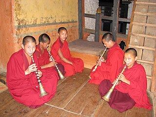
The music of Bhutan is an integral part of its culture and plays a leading role in transmitting social values. Traditional Bhutanese music includes a spectrum of subgenres, ranging from folk to religious song and music. Some genres of traditional Bhutanese music intertwine vocals, instrumentation, and theatre and dance, while others are mainly vocal or instrumental. The much older traditional genres are distinguished from modern popular music such as rigsar.

Trashigang District is Bhutan's easternmost dzongkhag (district).

Paro District is a district (dzongkhag), valley, river and town in Bhutan. It is one of the most historic valleys in Bhutan. Both trade goods and invading Tibetans came over the pass at the head of the valley, giving Paro the closest cultural connection with Tibet of any Bhutanese district. The dominant language in Paro is Dzongkha, the national language.

Gasa District or Gasa Dzongkhag is one of the 20 dzongkhags (districts) comprising Bhutan. The capital of Gasa District is Gasa Dzong near Gasa. It is located in the far north of the county and spans the Middle and High regions of the Tibetan Himalayas. The dominant language of the district is Dzongkha, which is the national language. Related languages, Layakha and Lunanakha, are spoken by semi-nomadic communities in the north of the district. The People's Republic of China claims the northern part of Gasa District.

Ngawang Namgyal (1594–1651), known colloquially as The Bearded Lama, was a Tibetan Buddhist Drukpa Kagyu school Rinpoche, and the unifier of Bhutan as a nation-state. He was later granted the honorific title Zhabdrung Rinpoche, approximately "at whose feet one submits". In addition to unifying the various warring fiefdoms for the first time in the 1630s, he also sought to create a distinct Bhutanese cultural identity separate from the Tibetan culture from which it was derived.
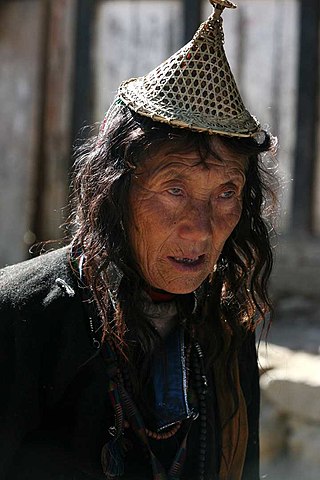
The Layap are an indigenous people inhabiting the high mountains of northwest Bhutan in the village of Laya, in the Gasa District, at an altitude of 3,850 metres (12,630 ft), just below the Tsendagang peak. Their population in 2003 stood at 1,100. They speak Layakha, a Tibeto-Burman language. Layaps refer to their homeland as Be-yul – "the hidden land."

The Second Tibetan Invasion of Bhutan or the Second Battle of Simtokha Dzong was a military confrontation in 1634 between the supporters of Zhabdrung Ngawang Namgyal and the forces of the Tibetan Tsangpa dynasty and several Bhutanese lamas allied against him. The latter initially conquered Zhabdrung's seat, Simtokha Dzong, threatening to eliminate his young dominion. The castle's ammunition stores were accidentally ignited during the battle, however, resulting in an explosion that destroyed Simtokha Dzong and much of the Tibetan army. Seizing this chance, Zhabdrung's followers rallied and ousted the Tibetans from their territory, turning the battle into a decisive strategic victory of Ngawang Namgyal, paving the way for the Unification of Bhutan under his rule.

Gasa is a town near Gasa Dzong in Gasa District in northwestern Bhutan.
Laya, Bhutan is a town in Laya Gewog in Gasa District in northwestern Bhutan. It is inhabited by the indigenous Layap people, and is the highest settlement in the country at 3,820 meters above sea level.
Lunana is a remote village in Gasa District in northwestern Bhutan. It is the capital of Lunana Gewog, which had a 2014 population of 810.

The Jigme Dorji National Park (JDNP), named after the late Jigme Dorji Wangchuck, is the second-largest National Park of Bhutan.
Bji Gewog is a gewog of Haa District, Bhutan. It is the northernmost gewog of the Haa District, bordering China's Chumbi Valley. The gewog has mostly mountainous terrain, with rivers flowing into Amo Chu in the west and the Ha Chu in the east. China claims a large part of the gewog as its territory and has recently started building roads and villages in the border areas.

Chiwogs of Bhutan or chios refer to the 1044 basic electoral precincts of Bhutan. Chiwogs are also former third-level administrative divisions of Bhutan below gewogs. Until 2009, they were the equivalent of municipalities or parishes, containing clusters of villages and hamlets. There are generally 5 or 6 chios in each geo, and in turn several geos in each dzongkha (district). To illustrate, there are 50 chios in Paro District alone. The majority of chios are small rural communities; more densely populated areas tend to be separate thromdes, or municipalities. A Chiwog Disaster Management Plan (CDMP) exists in some chios to form an effective responsive to any local disasters. Often, participants in the CDMP are also trained at a geo level for better coordination.
Khamaed is a gewog of the Gasa dzongkhag (district) in Bhutan. It was formerly known as Goenkhamae. Khamaed Gewog has a population of 1,057, which includes 562 men and 495 women.
Lunana Gewog is a gewog of Gasa District, Bhutan. The village Lunana is the administrative center of Lunana Gewog.
Laya is a Tibetic variety spoken by indigenous Layaps inhabiting the high mountains of northwest Bhutan in the village of Laya, Gasa District. Speakers also inhabit the northern regions of Thimphu and Punakha Districts. Its speakers are ethnically related to the Tibetans. Most speakers live at an altitude of 3,850 metres (12,630 ft), just below the Tsendagang peak. Laya speakers are also called Bjop by the Bhutanese, sometimes considered a condescending term. There were 1,100 speakers of Laya in 2003.
The Lunana language, Lunanakha is a Tibetic language spoken in Bhutan by some 700 people in 1998. Most are yak-herding pastoralists. Lunana is a variety of Dzongkha, the national language of Bhutan.
The mountains of Bhutan are some of the most prominent natural geographic features of the kingdom. Located on the southern end of the Eastern Himalaya, Bhutan has one of the most rugged mountain terrains in the world, whose elevations range from 160 metres (520 ft) to more than 7,000 metres (23,000 ft) above sea level, in some cases within distances of less than 100 kilometres (62 mi) of each other. Bhutan's highest peak, at 7,570 metres (24,840 ft) above sea level, is north-central Gangkhar Puensum, close to the border with Tibet; the third highest peak, Jomolhari, overlooking the Chumbi Valley in the west, is 7,314 metres (23,996 ft) above sea level; nineteen other peaks exceed 7,000 metres (23,000 ft). Weather is extreme in the mountains: the high peaks have perpetual snow, and the lesser mountains and hewn gorges have high winds all year round, making them barren brown wind tunnels in summer, and frozen wastelands in winter. The blizzards generated in the north each winter often drift southward into the central highlands.
