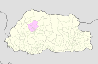
Haa District is one of the 20 dzongkhag or districts comprising Bhutan. Per the 2015 census, the population of Haa dzongkhag was 13499,1572 households making it the second least populated dzongkhag in Bhutan after Gasa. The dominant language of the district is Dzongkha, the national language.

Trashigang District is Bhutan's easternmost dzongkhag (district).

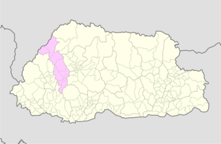
Paro District is a district (dzongkhag), valley, river and town in Bhutan. It is one of the most historic valleys in Bhutan. Both trade goods and invading Tibetans came over the pass at the head of the valley, giving Paro the closest cultural connection with Tibet of any Bhutanese district. The dominant language in Paro is Dzongkha, the national language.

Chukha District is one of the 20 dzongkhag (districts) comprising Bhutan. The major town is Phuentsholing which is the gateway city along the sole road which connects India to western Bhutan. Chukha is the commercial and the financial capital of Bhutan. With Bhutan's oldest hydropower plant, Chukha hydel, and Tala Hydroelectricity Project, the country's largest power plant, Chukha is the dzongkhag which contributes the most to the GDP of the country. Also located in Chukha district are some of the country's oldest industrial companies like the Bhutan Carbide Chemical Limited (BCCL) and the Bhutan Boards Products Limited (BBPL).
Dagana District is populated mostly by Dzongkha speakers, however in the southwest near Sarpang District, Nepali is also spoken as a native language.
Punakha District is one of the 20 dzongkhags (districts) comprising Bhutan. It is bordered by Thimphu, Gasa, and Wangdue Phodrang Districts. The dominant language in the district is Dzongkha, the national language.

Samtse District is one of the 20 dzongkhags (districts) comprising Bhutan.
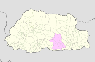
Zhemgang District, is one of the 20 dzongkhags (districts) comprising Bhutan. It is bordered by Sarpang, Trongsa, Bumthang, Mongar and Samdrup Jongkhar Districts, and borders Assam in India to the south. Administrative center of the district is Zhemgang.

Lingzhi Yügyal Dzong, is an important Drukpa Kagyu monastery and administrative center situated at an altitude of 4150 metres in Lingzhi, Thimphu District, Bhutan. There are about thirty monks headed by a Lama Neten resident in the Dzong. The office of the Drungpa is also housed in the Dzong.
Chang Gewog is a gewog of Thimphu District, Bhutan.
Darkala Gewog is a gewog of Thimphu District, Bhutan.
Genye Gewog is a gewog of Thimphu District, Bhutan.
Kawang Gewog is a gewog of Thimphu District, Bhutan.As of 2005 it has a population of 2582 and covers an area of 307 square kilometres.
Mewang Gewog is a gewog of Thimphu District, Bhutan.
Naro Gewog is a gewog of Thimphu District, Bhutan. Naro Gewog, along with Lingzhi and Soe Gewogs, is part of Lingzhi Dungkhag.

Soe Gewog is a gewog of Thimphu District, Bhutan. Soe Gewog, along with Naro and Lingzhi Gewogs, is part of Lingzhi Dungkhag.
Toepisa Gewog is a gewog of Punakha District, Bhutan. It used to be part of Thimphu District.

Laya is a Tibetic variety spoken by indigenous Layaps inhabiting the high mountains of northwest Bhutan in the village of Laya, Gasa District. Speakers also inhabit the northern regions of Thimphu and Punakha Districts. Its speakers are ethnically related to the Tibetans. Most speakers live at an altitude of 3,850 metres (12,630 ft), just below the Tsendagang peak. Laya speakers are also called Bjop by the Bhutanese, sometimes considered a condescending term. There were 1,100 speakers of Laya in 2003.