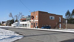
Le Grand, Iowa

Last updated

Le Grand, Iowa
Le Grand, Iowa.jpg
Le Grand, Iowa
Marshall County Iowa Incorporated and Unincorporated areas Le Grand Highlighted.svg
Location of Le Grand, Iowa
Coordinates: 42°0′22″N92°46′35″W / 42.00611°N 92.77639°W / 42.00611; -92.77639
Country Flag of the United States.svg  United States
State Flag of Iowa.svg  Iowa
Counties Marshall, Tama
Area
[1]
  Total1.05 sq mi (2.71 km2)
  Land1.04 sq mi (2.69 km2)
  Water0.01 sq mi (0.02 km2)
Elevation
932 ft (284 m)
Population
 (2020)
  Total905
  Density871.03/sq mi (336.44/km2)
Time zone UTC-6 (Central (CST))
  Summer (DST) UTC-5 (CDT)
ZIP code
50142
Area code 641
FIPS code 19-44220
GNIS feature ID0458254
Website https://www.legrandiowa.com/

Le Grand is a city in Marshall and Tama counties in the U.S. state of Iowa. [2] The population was 905 at the time of the 2020 census. [3]

Contents

History

Le Grand was laid out in 1852, and it was incorporated in 1891. [4] [5] The city was named for Le Grande Byington, the original owner of the town site. [6]

Geography

Le Grand's longitude and latitude coordinates in decimal form are 42.006211, -92.776497. [7]

According to the United States Census Bureau, the city has a total area of 1.05 square miles (2.72 km2), of which 1.04 square miles (2.69 km2) is land and 0.01 square miles (0.03 km2) is water. [8]

Demographics

Historical populations
YearPop.±%
1880 341    
1900 408+19.6%
1910 338−17.2%
1920 320−5.3%
1930 382+19.4%
1940 329−13.9%
1950 393+19.5%
1960 465+18.3%
1970 565+21.5%
1980 921+63.0%
1990 854−7.3%
2000 883+3.4%
2010 938+6.2%
2020 905−3.5%
Source: "U.S. Census website". United States Census Bureau . Retrieved March 29, 2020. and Iowa Data Center
Source:
U.S. Decennial Census [9] [3]

2010 census

As of the census [10] of 2010, there were 938 people, 382 households, and 276 families living in the city. The population density was 901.9 inhabitants per square mile (348.2/km2). There were 401 housing units at an average density of 385.6 per square mile (148.9/km2). The racial makeup of the city was 97.1% White, 0.1% African American, 0.4% Native American, 0.1% Asian, 0.1% Pacific Islander, 1.6% from other races, and 0.5% from two or more races. Hispanic or Latino of any race were 3.5% of the population.

There were 382 households, of which 32.2% had children under the age of 18 living with them, 55.8% were married couples living together, 11.3% had a female householder with no husband present, 5.2% had a male householder with no wife present, and 27.7% were non-families. 23.6% of all households were made up of individuals, and 8.1% had someone living alone who was 65 years of age or older. The average household size was 2.46 and the average family size was 2.87.

The median age in the city was 41.9 years. 25.3% of residents were under the age of 18; 7.3% were between the ages of 18 and 24; 22.2% were from 25 to 44; 29.1% were from 45 to 64; and 16% were 65 years of age or older. The gender makeup of the city was 48.8% male and 51.2% female.

2000 census

As of the census [11] of 2000, there were 883 people, 339 households, and 261 families living in the city. The population density was 847.0 inhabitants per square mile (327.0/km2). There were 353 housing units at an average density of 338.6 per square mile (130.7/km2). The racial makeup of the city was 97.96% White, 0.34% African American, 0.45% Native American, 0.34% Asian, 0.23% from other races, and 0.68% from two or more races. Hispanic or Latino of any race were 1.81% of the population.

There were 339 households, out of which 36.3% had children under the age of 18 living with them, 64.9% were married couples living together, 10.3% had a female householder with no husband present, and 23.0% were non-families. 20.6% of all households were made up of individuals, and 8.8% had someone living alone who was 65 years of age or older. The average household size was 2.60 and the average family size was 3.00.

27.4% are under the age of 18, 7.2% from 18 to 24, 26.2% from 25 to 44, 25.4% from 45 to 64, and 13.8% who were 65 years of age or older. The median age was 36 years. For every 100 females, there were 95.4 males. For every 100 females age 18 and over, there were 94.2 males.

The median income for a household in the city was $39,333, and the median income for a family was $42,153. Males had a median income of $33,333 versus $23,036 for females. The per capita income for the city was $16,470. About 3.3% of families and 4.5% of the population were below the poverty line, including 5.3% of those under age 18 and 5.0% of those age 65 or over.

Education

East Marshall Community School District serves the community. [12] The district was established on July 1, 1992 by the merger of the LDF and SEMCO school districts. [13]

Notable person

Jack Coombs, nicknamed "Colby Jack" after his alma mater was an American professional baseball player. Leading the league in wins 1910 and 1911. The 3x World Champion is in the Philadelphia Baseball Wall of Fame

See also

Related Research Articles

<span class="mw-page-title-main">Boxholm, Iowa</span> City in Iowa, United States

Boxholm is a city in Grant Township, Boone County, Iowa, United States. The population was 181 at the 2020 census. It is part of the Boone, Iowa Micropolitan Statistical Area, which is a part of the larger Ames-Boone, Iowa Combined Statistical Area.

<span class="mw-page-title-main">Sumner, Iowa</span> City in Iowa, United States

Sumner is a city in Bremer County, Iowa, United States. The city is located along the county's eastern border, between Bremer and Fayette counties. The population was 2,021 at the time of the 2020 census. The Bremer County portion of Sumner is part of the Waterloo–Cedar Falls Metropolitan Statistical Area.

<span class="mw-page-title-main">Grand River, Iowa</span> City in Iowa, United States

Grand River is a city in northwest Decatur County, Iowa, United States. The population was 196 at the time of the 2020 census.

<span class="mw-page-title-main">Woodbine, Iowa</span> City in Iowa, United States

Woodbine is a city in Harrison County, Iowa, United States, along the Boyer River. The population was 1,625 at the time of the 2020 census.

<span class="mw-page-title-main">Walker, Iowa</span> City in Iowa, United States

Walker is a city in Linn County, Iowa. The population was 688 at the 2020 census. It is part of the Cedar Rapids, Iowa metropolitan area.

<span class="mw-page-title-main">Leighton, Iowa</span> City in Iowa, United States

Leighton is a city in Mahaska County, Iowa, United States. The population was 158 in the 2020 census, an increase from 153 in the 2000 census.

<span class="mw-page-title-main">Albion, Iowa</span> City in Iowa, United States

Albion is a city in Marshall County, Iowa, United States. The population was 448 at the 2020 census.

<span class="mw-page-title-main">Ferguson, Iowa</span> City in Iowa, United States

Ferguson is a city in Marshall County, Iowa, United States. The population was 97 at the time of the 2020 census.

<span class="mw-page-title-main">Gilman, Iowa</span> City in Iowa, United States

Gilman is a city in the southeastern corner of Marshall County, Iowa, United States. The population was 542 at the time of the 2020 census.

<span class="mw-page-title-main">Laurel, Iowa</span> City in Iowa, United States

Laurel is a city in Marshall County, Iowa, United States. The population was 220 at the time of the 2020 census.

<span class="mw-page-title-main">Melbourne, Iowa</span> City in Iowa, United States

Melbourne is a city in Marshall County, Iowa, United States. The population was 786 at the time of the 2020 census.

<span class="mw-page-title-main">St. Anthony, Iowa</span> City in Iowa, United States

St. Anthony is a city in Marshall County, Iowa, United States. The population was 76 at the time of the 2020 census.

<span class="mw-page-title-main">State Center, Iowa</span> City in Iowa, United States

State Center is a city in Marshall County, Iowa, United States. The population was 1,391 at the time of the 2020 census. State Center is known as the Rose Capital of Iowa.

<span class="mw-page-title-main">Craig, Iowa</span> City in Iowa, United States

Craig is a city in Plymouth County, Iowa, United States. The population was 79 at the 2020 census.

<span class="mw-page-title-main">Macedonia, Iowa</span> City in Iowa, United States

Macedonia is a city in Pottawattamie County, Iowa, United States. The population was 267 at the time of the 2020 census.

<span class="mw-page-title-main">Minden, Iowa</span> City in Iowa, United States

Minden is a city in Pottawattamie County, Iowa, United States. The population was 600 at the time of the 2020 census. It has possessed a post office since 1875.

<span class="mw-page-title-main">Diagonal, Iowa</span> City in Iowa, United States

Diagonal is a city in northwest Ringgold County, Iowa, the United States. The population was 344 at the time of the 2020 census.

<span class="mw-page-title-main">Kellerton, Iowa</span> City in Iowa, United States

Kellerton is a city in eastern Ringgold County, Iowa, United States. The population was 243 at the time of the 2020 census.

<span class="mw-page-title-main">Dixon, Iowa</span> City in Iowa, United States

Dixon is a city in Scott County, Iowa, United States. The population was 202 at the time of the 2020 census.

<span class="mw-page-title-main">North English, Iowa</span> City in Iowa, United States

North English is a city located mainly in Iowa county with a small portion in Keokuk county in the U.S. state of Iowa. The population was 1,065 at the time of the 2020 census. It is named for the English River.

References

  1. "2020 U.S. Gazetteer Files". United States Census Bureau. Retrieved March 16, 2022.
  2. "About Us - Le Grand, Iowa". Le Grand, Iowa. September 25, 2020.
  3. 1 2 "2020 Census State Redistricting Data". census.gov. United states Census Bureau. Retrieved August 12, 2021.
  4. Battin, William (1912). Past and Present of Marshall County, Iowa, Volume 1. Brookhaven Press. p. 180. ISBN   9781581038972.
  5. The History of Marshall County, Iowa: Containing a History of the County, Its Cities, Towns, &c. Western Historical Co. 1878. pp.  529.
  6. Chicago and North Western Railway Company (1908). A History of the Origin of the Place Names Connected with the Chicago & North Western and Chicago, St. Paul, Minneapolis & Omaha Railways. p. 93.
  7. "US Gazetteer files: 2010, 2000, and 1990". United States Census Bureau. February 12, 2011. Retrieved April 23, 2011.
  8. "US Gazetteer files 2010". United States Census Bureau. Archived from the original on January 25, 2012. Retrieved May 11, 2012.
  9. "Census of Population and Housing". Census.gov. Retrieved June 4, 2015.
  10. "U.S. Census website". United States Census Bureau . Retrieved May 11, 2012.
  11. "U.S. Census website". United States Census Bureau . Retrieved January 31, 2008.
  12. "East Marshall" (PDF). Iowa Department of Education . Retrieved March 25, 2020.
  13. "REORGANIZATION & DISSOLUTION ACTIONS SINCE 1965-66" (PDF). Iowa Department of Education. Archived from the original (PDF) on February 9, 2019. Retrieved March 22, 2020.