Related Research Articles

The City of Leadville is a statutory city that is the county seat, the most populous community, and the only incorporated municipality in Lake County, Colorado, United States. The city population was 2,602 at the 2010 census and an estimated 2,762 in 2018. Leadville is situated at an elevation of 10,152 feet (3,094 m).
The Colorado Silver Boom was a dramatic expansionist period of silver mining activity in the U.S. state of Colorado in the late 19th century. The boom started in 1879 with the discovery of silver at Leadville. Over 82 million dollars worth of silver was mined during the period, making it the second great mineral boom in the state, and coming 20 years after the earlier and shorter Colorado Gold Rush of 1859. The boom was largely the consequence of large-scale purchases of silver by the United States Government authorized by Congress in 1878. The boom endured throughout the 1880s, resulting in an intense increase in both the population and wealth of Colorado, especially in the mountains. It came to an end in 1893 in the wake of the collapse of silver prices caused by the repeal of Sherman Silver Purchase Act.
Neville Langrell "Bill" Barlee was a Canadian politician who was first elected to the Legislative Assembly of British Columbia as a New Democrat in 1988. He served as Minister of Agriculture, Fisheries and Food from 1991 until 1993 and then as Minister of Small Business, Tourism and Culture from 1993 until 1996.

The Collegiate Peaks Wilderness is a 168,000-acre (680 km2) area located in central Colorado between Leadville and Buena Vista to the east and Aspen to the west and Crested Butte to the southwest. Most of the area is in the San Isabel and Gunnison National Forests, with a smaller area in the White River National Forest southeast of Aspen. Most of the area is in northwest Chaffee County with smaller portions in Gunnison, Pitkin, and Lake counties.

Clinton Creek is a ghost town in Yukon. It was a small company-owned asbestos mining town in western Yukon near the confluence of the Yukon and Fortymile rivers. It operated by the Cassiar Asbestos Corporation, which also operated the asbestos mine in Cassiar, British Columbia, from 1967 to 1978, when it was closed and the buildings auctioned off.
Top of the Rockies is the name of a National Scenic Byway in Colorado, in the Western United States. Most of the byway is above 9,000 ft (2,700 m) and thus the name of the byway is Top of the Rockies. The byway goes over Tennessee Pass to the mining town of Leadville, Colorado.
A silver rush is the silver-mining equivalent of a gold rush, where the discovery of silver-bearing ore sparks a mass migration of individuals seeking wealth in the new mining region.
Emory Creek Provincial Park is a provincial park in British Columbia, Canada, located on the west side of the Fraser River just south of the town of Yale. It commemorates the location of a large boomtown, variously known as Emory, Emory Bar or Emory City, that first rose during the Fraser Canyon Gold Rush but became a major construction town during the building of the Canadian Pacific Railway in the 1880s.
Emory Creek in 1858 was a tent and shack camp, established by miners in search of gold. When it became evident that the gold was not available in the amounts estimated, the miners started moving north on the Fraser River. A few Chinese remained in the area. The area came into the hands of a man named Walker, who felt Emory Creek would become the head of riverboat navigation on the Fraser. Eventually, he sold the land to the Oppenheimer Brothers in early 1879. In the fall of 1879, Emory was chosen by the C.P.R. as the western terminus. In a short time it became Emory Creek. The town consisted of thirteen streets with its own newspaper, various shops, a brewery, nine saloons and a sawmill. When Yale was made the terminus, Emory was all but abandoned by 1885, with the completion of the railway. Today, it is an easily accessible treed campground with paved roads and flush outhouses.

Ashcroft, originally known as Castle Forks City then Chloride until 1882, was a mining town located ten miles (16 km) south of Aspen, Colorado, United States. A few buildings remain standing as a testament to the town's past.

Granite is an unincorporated community with a U.S. Post Office in Chaffee County, Colorado, United States. The zip code of Granite is 81228. According to the 2010 census, the population is 116.
The Similkameen Gold Rush, also known as the Blackfoot Gold Rush, was a minor gold rush in the Similkameen Country of the Southern Interior of British Columbia, Canada, in 1860. The Similkameen Rush was one of a flurry of small rushes peripheral to the Fraser Canyon Gold Rush, which had drawn tens of thousands of prospectors to the new colony in 1858-1859, among the others being Rock Creek Gold Rush and Big Bend.
The Cassiar Country, also referred to simply as the Cassiar, is a historical geographic region of the Canadian province of British Columbia. The Cassiar is located in the northwest portion of British Columbia, just to the northeast of the Stikine Country, while to the south is the Omineca Country. The area is noted for the Cassiar gold rush of the 1870s, when Laketon became its unofficial capital. The ghost town of Cassiar is also located in the Cassiar region.
Fisherville is a classic example of a boom and bust gold rush town that characterized the 1860s in British Columbia. Gold was discovered here in 1864. As the first permanent white settlement in the East Kootenay region of the Southern Interior, Fisherville boasted a population of 5,000 inhabitants in 1865 and numerous buildings including six general stores, four saloons, two butcher shops, a brewery, a blacksmith’s shop, a boarding house, a post office, a sawmill, and government offices.

A mining community, also known as a mining town or a mining camp, is a community that houses miners. Mining communities are usually created around a mine or a quarry.
Granite Creek is a creek and townsite in British Columbia located in the Similkameen region. Granite Creek flows north into the Tulameen River and joins that river approximately one and a half miles to the east of Coalmont, British Columbia. It is assumed Granite Creek yielded more than $500,000 in placer gold since its discovery. Gold nuggets worth $50 in value were not unusual in the early years. The creek was mined by Europeans and Chinese. Granite Creek was hydraulicked near its mouth in the 1890s.
"Granite City" is the informal name for the mining settlement located near Granite Creek. Established during the 1885 gold rush, Granite Creek townsite is now a ghost town in the Similkameen region of British Columbia, Canada.

Independence is a ghost town in the U.S. state of Colorado. It is located just off State Highway 82 in the eastern corner of Pitkin County, below the Continental Divide. It was the first settlement established in the Roaring Fork Valley, after gold was struck in the vicinity on Independence Day, July 4, 1879, hence its name. In 1973 it was recognized as a historic district and listed on the National Register of Historic Places as Independence and Independence Mill Site, one of two ghost towns in the county so recognized. It has also been known historically by other names—Chipeta, Mammoth City, Mount Hope, Farwell, Sparkill and Hunter's Pass.
Champion Creek is a ghost town located in the West Kootenay region of British Columbia. It is a former Doukhobor settlement. The town is near Champion Creek on the east side of Columbia River, between Trail and Castlegar.

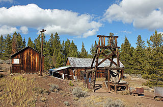
Vicksburg was a town and mining camp in Chaffee County, Colorado, high in Clear Creek Canyon. It is now effectively a ghost town, although some of the buildings may be seasonally occupied by their owners. The site was listed on the National Register of Historic Places in 1977 ; a part of the town is maintained by the Chaffee County Historical Society as a museum. Four miles farther up the same road on which Vicksburg is located is another old mining camp named Winfield.
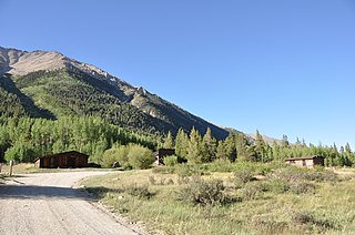
Winfield is a ghost town in Chaffee County, Colorado, United States. It is estimated that as many as 1,500 people may have lived in Winfield.
References
- ↑ Basque Garnet (1982), British Columbia Ghost Town Atlas. Sunfire Publications Limited.
| | This Canadian ghost town-related article is a stub. You can help Wikipedia by expanding it. |