The Grand Union Canal in England is part of the British canal system. It is the principal navigable waterway between London and the Midlands. Starting in London, one arm runs to Leicester and another ends in Birmingham, with the latter stretching for 137 miles (220 km) with 166 locks from London. The Birmingham line has a number of short branches to places including Slough, Aylesbury, Wendover, and Northampton. The Leicester line has two short arms of its own, to Market Harborough and Welford.

The Forth and Clyde Canal is a canal opened in 1790, crossing central Scotland; it provided a route for the seagoing vessels of the day between the Firth of Forth and the Firth of Clyde at the narrowest part of the Scottish Lowlands. This allowed navigation from Edinburgh on the east coast to the port of Glasgow on the west coast. The canal is 35 miles (56 km) long and it runs from the River Carron at Grangemouth to the River Clyde at Bowling, and had an important basin at Port Dundas in Glasgow.

The Falkirk Wheel is a rotating boat lift in Tamfourhill, Falkirk, in central Scotland, connecting the Forth and Clyde Canal with the Union Canal. It opened in 2002 as part of the Millennium Link project, reconnecting the two canals for the first time since the 1930s.
The Forth Canoe Club, founded in 1934, is Scotland's oldest surviving canoe club. It is the only remaining club to have been a participating party in the founding of the Scottish Canoe Association. The other canoe clubs that were founding parties where Clyde, Tay and the Scottish Youth Hostellers.

The Union Canal, full name the Edinburgh and Glasgow Union Canal, is a canal in Scotland, running from Falkirk to Edinburgh, constructed to bring minerals, especially coal, to the capital. It was opened in 1822 and was initially successful, but the construction of railways, particularly the Edinburgh and Glasgow Railway, which opened in 1842, diminished its value as a transport medium. It fell into slow commercial decline and was closed to commercial traffic in 1933. It was officially closed in 1965. The canal is listed as three individual scheduled monuments by Historic Scotland according to the three former counties, Midlothian, West Lothian and Stirlingshire, through which it flows.

The Forth and Clyde canal pathway runs between the Firth of Forth and the Firth of Clyde and is a 106-kilometre-long (66 mi) footpath and cycleway that runs across Scotland, between Bowling, west of Glasgow, and Lochrin Basin in Edinburgh. The path runs on the towpaths of the Forth & Clyde and Union Canals and is entirely off-road. The path is well maintained and its surface is generally good, although there are some stretches particularly between Falkirk and the outskirts of Edinburgh where wet weather leads to muddy conditions unsuitable for road intended bicycles. It is well used by walkers and cyclists, and designated as one of Scotland's Great Trails by NatureScot. It also forms part of the National Cycle Network, being designated as Route 754. Sustrans advises that the path is best followed from the Clyde to the Forth because the prevailing wind is from the south west. Much of the path is also suitable for experienced horseriders, although in some places low bridges, narrow aqueducts and gates may restrict access for horses.

Linlithgow is a town in West Lothian, Scotland. It was historically West Lothian's county town, reflected in the county's historical name of Linlithgowshire. An ancient town, it lies in the Central Belt on a historic route between Edinburgh and Falkirk beside Linlithgow Loch. The town is situated approximately 20 miles (32 km) west of Edinburgh.

Fountainbridge is a former industrial district in Edinburgh, Scotland, a short distance west of the Old Town. It is built around the street of the same name, which begins at the West Port and continues towards Gorgie and Dalry. The district is bounded on the south by the final stretch of the Union Canal and on the north by the West Approach Road, built on the route of the old Caledonian Railway.

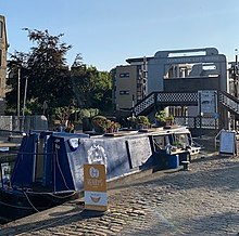
Lochrin is a small area in Edinburgh, the capital of Scotland. It is in the south-west corner of the city centre, to the west of Tollcross, and south of Fountainbridge. Lochrin contains a wide mixture of retail shops, leisure facilities, other businesses and tenement housing. Major new office and residential developments have replaced some of the older buildings.

The Almond Aqueduct, also known as the Lin's Mill Aqueduct, is a navigable aqueduct that carries the Union Canal over the River Almond in Scotland, west of Ratho, Edinburgh.

The Slateford Aqueduct is a navigable aqueduct that carries the Union Canal over the Water of Leith at Slateford, Edinburgh, Scotland. Completed in 1822, it has eight arches and spans a length of 500 feet (150 m).

The Edinburgh Union Canal Society is a charitable canal society on the Union Canal in Edinburgh, Scotland. The Society's main base is Ashley Terrace Boathouse at Lockhart Bridge, near Harrison Park in the Polwarth area of Edinburgh.
The Scott Russell Aqueduct is an aqueduct carrying the Union Canal over the Edinburgh City Bypass, west of Edinburgh, Scotland.

The Bonnington Aqueduct is an aqueduct on the Union Canal, to the west of Edinburgh, Scotland.

Port Dundas is an area of Glasgow, Scotland, located 1 mile (1.6 km) to the north of the city centre. It lies to the north of Cowcaddens, and to the west of Sighthill, with Hamiltonhill and Possilpark to the north-west.
Events from the year 1822 in Scotland.

The Victoria Swing Bridge is a swing bridge in Leith docks, Edinburgh, Scotland, which carries a dock road across the Water of Leith at a point where it is canalised as the Inner Harbour.

Stockingfield Junction is a canal junction which lies between Maryhill and Ruchill in Glasgow, Scotland. It opened in 1777, and closed in 1963, followed by restoration and a re-opening in 2022. At first a terminus it formed the junction for the Port Dundas branch off the Forth and Clyde Canal main line from 1777.
Donald's Quay was once the location of the northern terminus of the Erskine Ferry then run by Lord Blantyre of Erskine House that provided foot passengers with a crossing of the River Clyde, giving direct access between Dunbartonshire and Renfrewshire. At some point in the early 19th century the northern terminus of the Erskine Ferry moved to a site closer to Old Kilpatrick and opposite the Ferry House at Erskine, before closure in 1971 when the Erskine Bridge was completed. Donald's Quay once had an approximately 170-foot-long (52-metre) stone pier that was used by coal boats that transferred their loads into canal barges on the Forth & Clyde Canal at Ferrydyke Wharf and thereby avoided paying fees at the Bowling Basin. The quay was demolished during the construction of the Lanarkshire and Dumbartonshire Railway in 1896.