Lebanon, South Dakota

Last updated

Lebanon, South Dakota
Potter County South Dakota Incorporated and Unincorporated areas Lebanon Highlighted.svg
Location in Potter County and the state of South Dakota
Coordinates: 45°04′08″N99°45′59″W / 45.06889°N 99.76639°W / 45.06889; -99.76639
Country United States
State South Dakota
County Potter
Incorporated1917 [1]
Area
[2]
  Total0.53 sq mi (1.37 km2)
  Land0.53 sq mi (1.37 km2)
  Water0.00 sq mi (0.00 km2)
Elevation
[3]
1,952 ft (595 m)
Population
 (2020) [4]
  Total33
  Density62.26/sq mi (24.02/km2)
Time zone UTC-6 (Central (CST))
  Summer (DST) UTC-5 (CDT)
ZIP code
57455
Area code 605
FIPS code 46-36260 [5]
GNIS feature ID1267456 [3]

Lebanon is a town in Potter County, South Dakota, United States. The population was 33 at the 2020 census. [6]

Contents

History

Lebanon was first called Webb, and under the latter name was platted in 1887. [7] The present name most likely is after Lebanon, New York, [7] although some hold it is named after Mount Lebanon in Western Asia. [8]

Geography

According to the United States Census Bureau, the town has a total area of 0.53 square miles (1.37 km2), all land. [9]

Demographics

Historical population
CensusPop.Note
1920 325
1930 3342.8%
1940 310−7.2%
1950 215−30.6%
1960 198−7.9%
1970 182−8.1%
1980 129−29.1%
1990 115−10.9%
2000 86−25.2%
2010 47−45.3%
2020 33−29.8%
U.S. Decennial Census [10] [4]

2010 census

As of the census [11] of 2010, there were 47 people, 23 households, and 11 families residing in the town. The population density was 88.7 inhabitants per square mile (34.2/km2). There were 40 housing units at an average density of 75.5 per square mile (29.2/km2). The racial makeup of the town was 91.5% White, 4.3% Native American, and 4.3% from two or more races.

There were 23 households, of which 21.7% had children under the age of 18 living with them, 39.1% were married couples living together, 8.7% had a female householder with no husband present, and 52.2% were non-families. 34.8% of all households were made up of individuals, and 13% had someone living alone who was 65 years of age or older. The average household size was 2.04 and the average family size was 2.55.

The median age in the town was 49.5 years. 19.1% of residents were under the age of 18; 6.5% were between the ages of 18 and 24; 17% were from 25 to 44; 38.3% were from 45 to 64; and 19.1% were 65 years of age or older. The gender makeup of the town was 55.3% male and 44.7% female.

2000 census

As of the census [5] of 2000, there were 86 people, 39 households, and 28 families residing in the town. The population density was 160.8 inhabitants per square mile (62.1/km2). There were 54 housing units at an average density of 100.9 per square mile (39.0/km2). The racial makeup of the town was 98.84% White and 1.16% Native American.

There were 39 households, out of which 28.2% had children under the age of 18 living with them, 59.0% were married couples living together, 12.8% had a female householder with no husband present, and 28.2% were non-families. 25.6% of all households were made up of individuals, and 17.9% had someone living alone who was 65 years of age or older. The average household size was 2.21 and the average family size was 2.61.

In the town, the population was spread out, with 18.6% under the age of 18, 4.7% from 18 to 24, 14.0% from 25 to 44, 30.2% from 45 to 64, and 32.6% who were 65 years of age or older. The median age was 53 years. For every 100 females, there were 104.8 males. For every 100 females age 18 and over, there were 89.2 males.

The median income for a household in the town was $25,625, and the median income for a family was $37,500. Males had a median income of $47,500 versus $18,750 for females. The per capita income for the town was $16,135. There were 13.6% of families and 24.3% of the population living below the poverty line, including 37.5% of under eighteens and 17.2% of those over 64.

Related Research Articles

<span class="mw-page-title-main">Ross, North Dakota</span> City in North Dakota, United States

Ross is a city in Mountrail County, North Dakota, United States. The population was 95 at the 2020 census.

<span class="mw-page-title-main">Wolsey, South Dakota</span> Town in South Dakota, United States

Wolsey is a town in Beadle County, South Dakota, United States. The population was 459 at the 2020 census.

<span class="mw-page-title-main">Stratford, South Dakota</span> Town in South Dakota, United States

Stratford is a town in southern Brown County, South Dakota, United States. The population was 57 at the 2020 census.

<span class="mw-page-title-main">Westport, South Dakota</span> Town in South Dakota, United States

Westport is a town in western Brown County, South Dakota, United States. The population was 88 at the 2020 census.

<span class="mw-page-title-main">Mound City, South Dakota</span> Town in South Dakota, United States

Mound City is a town in and the county seat of Campbell County, South Dakota, United States. The population was 69 at the 2020 census.

<span class="mw-page-title-main">Ravinia, South Dakota</span> Town in South Dakota, United States

Ravinia is a town in Charles Mix County, South Dakota, United States. The population was 71 at the 2020 census.

<span class="mw-page-title-main">Bradley, South Dakota</span> Town in South Dakota, United States

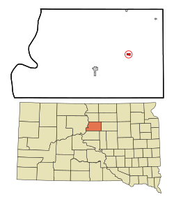
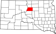
Bradley is a town in Clark County, South Dakota, United States. The population was 65 at the 2020 census.

<span class="mw-page-title-main">Florence, South Dakota</span> Town in South Dakota, United States

Florence is a town in northwestern Codington County, South Dakota, United States. It is part of the Watertown, South Dakota Micropolitan Statistical Area. The population was 337 at the 2020 census.

<span class="mw-page-title-main">Fairburn, South Dakota</span> Town in South Dakota, United States

Fairburn is a town in Custer County, South Dakota, United States. The population was 60 at the 2020 census.

<span class="mw-page-title-main">Onaka, South Dakota</span> Town in South Dakota, United States

Onaka is a town in Faulk County, South Dakota, United States. The population was 13 at the 2020 census.

<span class="mw-page-title-main">Revillo, South Dakota</span> Town in South Dakota, United States

Revillo is a town in southeastern Grant County, South Dakota, United States. The population was 99 at the 2020 census.

<span class="mw-page-title-main">Lake City, South Dakota</span> Town in South Dakota, United States

Lake City is a town in Marshall County, South Dakota, United States. The population was 45 at the 2020 census. Fort Sisseton Historic State Park, whose fort is listed on the National Register of Historic Places, is located nearby.

<span class="mw-page-title-main">Crooks, South Dakota</span> City in South Dakota, United States

Crooks is a city in Minnehaha County, South Dakota, United States and is a suburb of Sioux Falls. The population was 1,362 at the 2020 census. Crooks was named New Hope until 1904. The town's present name honors W. A. Crooks, a local politician.

<span class="mw-page-title-main">Sherman, South Dakota</span> Town in South Dakota, United States

Sherman is a town in Minnehaha County, South Dakota, United States. The population was 81 at the 2020 census.

<span class="mw-page-title-main">Corona, South Dakota</span> Town in South Dakota, United States

Corona is a town in Roberts County, South Dakota, United States. The population was 69 at the 2020 census.

<span class="mw-page-title-main">Tulare, South Dakota</span> Town in South Dakota, United States

Tulare is a town in Spink County, South Dakota, United States. The population was 211 at the 2020 census.

<span class="mw-page-title-main">New Witten, South Dakota</span> Town in South Dakota, United States

New Witten is a town in Tripp County, South Dakota, United States. The population was 54 at the 2020 census.

<span class="mw-page-title-main">Davis, South Dakota</span> Town in South Dakota, United States

Davis is a town in Turner County, South Dakota, United States. The population was 54 at the 2020 census.

<span class="mw-page-title-main">Dolton, South Dakota</span> Town in South Dakota, United States

Dolton is a town in Turner County, South Dakota, United States. The population was 34 at the 2020 census.

<span class="mw-page-title-main">Lowry, South Dakota</span> Town in South Dakota, United States

Lowry is a town in Walworth County, South Dakota, United States. The population was 10 at the 2020 census. The town is home to Lowry Pilgrim Community Church, Swan Creek Harness Shop, J & C Repair, Karst Service and a fire station. Lowry also has an abandoned school, and a post office, which closed to service in the early 1970s.

References

  1. "SD Towns" (PDF). South Dakota State Historical Society. Archived from the original (PDF) on February 10, 2010. Retrieved February 14, 2010.
  2. "ArcGIS REST Services Directory". United States Census Bureau. Retrieved October 15, 2022.
  3. 1 2 U.S. Geological Survey Geographic Names Information System: Lebanon, South Dakota
  4. 1 2 "Census Population API". United States Census Bureau. Retrieved October 15, 2022.
  5. 1 2 "U.S. Census website". United States Census Bureau . Retrieved January 31, 2008.
  6. "U.S. Census Bureau: Lebanon town, South Dakota". www.census.gov. United States Census Bureau. Retrieved March 24, 2022.
  7. 1 2 Chicago and North Western Railway Company (1908). A History of the Origin of the Place Names Connected with the Chicago & North Western and Chicago, St. Paul, Minneapolis & Omaha Railways. p. 93.
  8. Federal Writers' Project (1940). South Dakota place-names, v.1-3. University of South Dakota. p. 47.
  9. "US Gazetteer files 2010". United States Census Bureau. Archived from the original on July 2, 2012. Retrieved June 21, 2012.
  10. "Census of Population and Housing". Census.gov. Retrieved June 4, 2015.
  11. "U.S. Census website". United States Census Bureau . Retrieved June 21, 2012.