
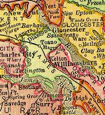
York County is a county in the eastern part of the Commonwealth of Virginia, located in the Tidewater. As of the 2020 census, the population was 70,045. The county seat is the unincorporated town of Yorktown.
Newport News is an independent city in southeastern Virginia, United States. At the 2020 census, the population was 186,247. Located in the Hampton Roads region, it is the fifth-most populous city in Virginia and 140th-most populous city in the United States. The city is at the southeastern end of the Virginia Peninsula, on the northern shore of the James River to the river's mouth on the harbor of Hampton Roads.

James City County is a county located in the Commonwealth of Virginia. As of the 2020 census, the population was 78,254. Although politically separate from the county, the county seat is the adjacent independent city of Williamsburg.

Yorktown is a town in York County, Virginia. It is the county seat of York County, one of the eight original shires formed in colonial Virginia in 1682. Yorktown's population was 195 as of the 2010 census, while York County's population was 66,134 in the 2011 census estimate.

The Virginia Peninsula is located in southeast Virginia, bounded by the York River, James River, Hampton Roads and Chesapeake Bay. It is sometimes known as the Lower Peninsula to distinguish it from two other peninsulas to the north, the Middle Peninsula and the Northern Neck.

Warwick County was a county in Southeast Virginia that was created from Warwick River Shire, one of eight created in the Virginia Colony in 1634. It became the City of Newport News on July 16, 1952. Located on the Virginia Peninsula on the northern bank of the James River between Hampton Roads and Jamestown, the area consisted primarily of farms and small unincorporated villages until the arrival of the Peninsula Extension of the Chesapeake and Ohio Railway in 1881 and development led by industrialist Collis P. Huntington.
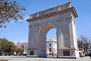
Grove is an unincorporated community in the southeastern portion of James City County in the Virginia Peninsula subregion of Virginia in the United States. It is located in the center of the Historic Triangle of Colonial Virginia, communities linked by the Colonial Parkway. This area is one of the busiest tourist destinations in the world.

Endview Plantation is an 18th-century plantation, including a park and historic home now operated by the independent city of Newport News, Virginia, located on Virginia State Route 238 in the Lee Hall community.

State Route 143 is a primary state highway in the U.S. state of Virginia. The state highway runs 35.39 miles (56.95 km) from Camp Peary near Williamsburg east to U.S. Route 258 at Fort Monroe in Hampton. SR 143 is a major local thoroughfare on the Virginia Peninsula portion of the Hampton Roads metropolitan area. The state highway is named Merrimac Trail through the independent city of Williamsburg and adjacent portions of York County and James City County. SR 143 follows Jefferson Avenue through the city of Newport News from the Williamsburg area past Virginia Peninsula Regional Jail to near Downtown Newport News. The state highway, which mostly runs northwest–southeast, heads northeast from Newport News, serving as one highway connecting the downtown areas of Newport News and Hampton. SR 143 parallels both US 60 and Interstate 64 (I-64) extensively, and sometimes very closely, throughout its course. The state highway also runs concurrently with US 60 in Hampton and with US 17 in Newport News.

State Route 238 is a primary state highway in the U.S. state of Virginia. The state highway runs 7.75 miles (12.47 km) from U.S. Route 60 in Newport News east to United States Coast Guard Training Center – Yorktown near Yorktown. SR 238 connects Interstate 64 (I-64) with Naval Weapons Station Yorktown, the Yorktown portion of Colonial National Historical Park, and the Coast Guard training center. The majority of SR 238 is part of the Washington–Rochambeau Revolutionary Route.

State Route 105 is a primary state highway in the U.S. state of Virginia. Known as Fort Eustis Boulevard, the state highway runs 4.90 miles (7.89 km) from Fort Eustis in Newport News east to U.S. Route 17 near Grafton in York County. SR 105 is a cross-peninsula highway that connects Fort Eustis, a U.S. Army installation, with US 60 and Interstate 64 (I-64), and US 17 near Yorktown.
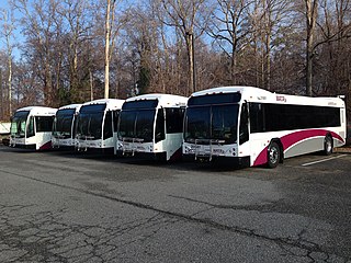
Williamsburg Area Transit Authority (WATA) is a multi-jurisdiction transportation agency providing transit bus and ADA Paratransit services in the City of Williamsburg, James City County, York County in the Historic Triangle area and Surry County, VA of the Virginia Peninsula subregion of Hampton Roads in southeastern Virginia.

U.S. Route 60 (US 60) in the Commonwealth of Virginia runs 303 miles (488 km) west to east through the central part of the state, generally close to and paralleling the Interstate 64 corridor, except for the crossing of the Blue Ridge Mountains, and in the South Hampton Roads area.
Camp Wallace was a facility of the United States Army located near the unincorporated town of Grove in southeastern James City County in the Virginia Peninsula portion of the Hampton Roads region of Virginia in the United States.

Skiffe's Creek is located in James City County and the independent city of Newport News in the Virginia Peninsula area of the Hampton Roads region of southeastern Virginia in the United States. It is a tributary of the James River.

Near the city's western end, a historic C&O railroad station, as well as American Civil War battle sites near historic Lee Hall along U.S. Route 60 and several 19th century plantations have all been protected. Many are located along the roads leading to Yorktown and Williamsburg, where many sites of the Historic Triangle are of both American Revolutionary War and Civil War significance. The first modern duel of ironclad warships, the Battle of Hampton Roads, took place not far off Newport News Point in 1862.
The city of Williamsburg, Virginia has a full range of transport facilities. Williamsburg is served by the Newport News/Williamsburg International Airport, and by two larger but more distant airports. The city is linked to several Interstate and State highways. A transport hub - the Williamsburg Transportation Center - serves bus and rail passengers. Motor traffic is restricted in the historic area, and the city as a whole is more "walkable" than the US norm. Cycling routes are also being provided.

The Peninsula Extension which created the Peninsula Subdivision of the Chesapeake and Ohio Railway (C&O) was the new railroad line on the Virginia Peninsula from Richmond to southeastern Warwick County. Its principal purpose was to provide an important new pathway for coal mined in West Virginia to reach the harbor of Hampton Roads for coastal and export shipping on collier ships.

Historically, the harbor was the key to the Hampton Roads area's growth, both on land and in water-related activities and events. Ironically, the harbor and its tributary waterways were both important transportation conduits and obstacles to other land-based commerce and travel. For hundreds of years, state and community leaders have worked to develop solutions to accommodate both.

Lee Hall Depot is a historic train station and museum located in the Lee Hall neighborhood of Newport News, Virginia. It was built in about 1881, with a one-story cargo bay, and the two-story main section was added in 1893. Another one-story wing was added by the Chesapeake and Ohio Railway to the north end of the depot in 1918 to handle an influx of military personnel to Fort Eustis. The building is currently in use as a local history museum, focusing on the station's history, and the history of the Chesapeake and Ohio Railway in Warwick County.


