
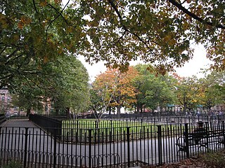
Crown Heights is a neighborhood in the central portion of the New York City borough of Brooklyn. Crown Heights is bounded by Washington Avenue to the west, Atlantic Avenue to the north, Ralph Avenue to the east, and Empire Boulevard/East New York Avenue to the south. It is about one mile (1.6 km) wide and two miles (3.2 km) long. Neighborhoods bordering Crown Heights include Prospect Heights to the west, Flatbush and Prospect Lefferts Gardens to the south, Brownsville to the east, and Bedford-Stuyvesant to the north.

Dyker Heights is a predominantly residential neighborhood in the southwest corner of the borough of Brooklyn in New York City. It is on a hill between Bay Ridge, Bensonhurst, Borough Park, and Gravesend Bay. The neighborhood is bounded by 7th and 14th Avenues, 65th Street, and the Belt Parkway on the west, east, north, and south, respectively.
Clinton Hill is a neighborhood in north-central Brooklyn, a borough of New York City. It is bordered by the Brooklyn Navy Yard and the Brooklyn-Queens Expressway to the north, Williamsburg to the northeast, Classon Avenue and Bedford–Stuyvesant to the east, Atlantic Avenue and Prospect Heights to the south and southwest and Vanderbilt Avenue and Fort Greene to the west.

Flatbush is a neighborhood in the New York City borough of Brooklyn. The neighborhood consists of several subsections in central Brooklyn and is generally bounded by Prospect Park to the north, East Flatbush to the east, Midwood to the south, and Kensington and Parkville to the west. The neighborhood had a population of 105,804 as of the 2010 United States Census. The modern neighborhood includes or borders several institutions of note, including Brooklyn College.

The Crown Heights riot was a race riot that took place from August 19 to August 21, 1991, in the Crown Heights section of Brooklyn, New York City. Black residents attacked Orthodox Jewish residents, damaged their homes, and looted businesses. The riots began on August 19, 1991, after two children of Guyanese immigrants were accidentally struck by a car running a red or yellow light while following the motorcade of Rebbe Menachem Mendel Schneerson, the leader of Chabad, a Jewish religious movement. One child died and the second was severely injured.

The Brooklyn City Railroad (BCRR) was the oldest and one of the largest operators of streetcars in the City of Brooklyn, New York, continuing in that role when Brooklyn became a borough of New York City in 1898.
Vanderbilt Avenue is the name of three thoroughfares in the New York City boroughs of Brooklyn, Manhattan, and Staten Island. They were named after Cornelius Vanderbilt (1794–1877), the builder of Grand Central Terminal in Midtown Manhattan.

Prospect Lefferts Gardens is a residential neighborhood in the Flatbush area of the New York City borough of Brooklyn. The community is bounded by Empire Boulevard to the north, Clarkson Avenue to the south, New York Avenue to the east, and Ocean Avenue/Prospect Park to the west. Prospect Lefferts Gardens was designated a NYC Landmark area in 1979 and called the Prospect Lefferts Gardens Historic District.
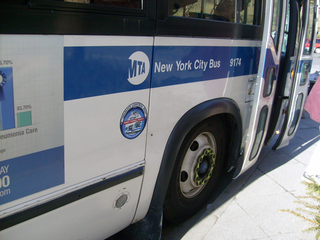
MTA Regional Bus Operations operates local and express buses serving New York City in the United States out of 29 bus depots. These depots are located in all five boroughs of the city, with the exception of one located in nearby Yonkers in Westchester County. 21 of these depots serve MTA New York City Transit (NYCT)'s bus operations, while the remaining eight serve the MTA Bus Company These facilities perform regular maintenance, cleaning, and painting of buses, as well as collection of revenue from bus fareboxes. Several of these depots were once car barns for streetcars, while others were built much later and have only served buses. Employees of the depots are represented by local divisions of the Transport Workers Union of America (TWU), particularly the TWU Local 100 and 101, or of the Amalgamated Transit Union (ATU)'s Local's 726 for all depots in Staten Island, 1056 for Casey Stengel, Jamaica, and Queens Village Depots, and 1179 for JFK & Far Rockaway Depots.
Wingate is a neighborhood in the north central portion of the New York City borough of Brooklyn. The area is bordered by Prospect Lefferts Gardens to the west, Crown Heights to the north and east, and East Flatbush to the south. Wingate is bounded by Empire Boulevard to the north, Troy Avenue to the east, Winthrop Street to the south, and New York Avenue to the west. The area is part of Brooklyn Community District 9. It is sometimes considered part of Crown Heights, East Flatbush, and/or Prospect Lefferts Gardens.
Juniper Valley Park is a 55.247-acre (223,580 m2) public park located within Middle Village, Queens, New York, United States. The park is bordered by Juniper Boulevard North on the north, Juniper Boulevard South on the south, Lutheran Avenue on the west, and Dry Harbor Road on the east; it is split into two parts by 80th Street.
Wallabout is a neighborhood in the New York City borough of Brooklyn that dates back to the 17th century. It is one of the oldest areas of Brooklyn, in the area that was once Wallabout Bay but has largely been filled in and is now the Brooklyn Navy Yard.

Wyckoff Heights is an area within the New York City boroughs of Brooklyn and Queens, straddling the border between Bushwick, Brooklyn, and southwest Ridgewood, Queens. Wyckoff Heights was urbanized starting in the late 19th century, and took its name from the Wyckoff family, who owned the land. The area was home first to many German immigrants, later followed by Italian and more recently Latino and Eastern-European residents.

Commercial Field is an athletic field located in the Wingate neighborhood of Brooklyn. It was home to the Commercial High School soccer, football, and baseball teams from around 1906. Other schools, such as Boys High, also called Commercial Field their home from time to time, as did local teams in the American Soccer League in the 1930s. The field was also the home field of the short-lived New York Brickley Giants, of the early National Football League, who played two games there during their 1921 season. In 1926, the Brooklyn Horsemen of the first American Football League used the stadium as their home field.
Interfaith Medical Center is a hospital located in Brooklyn, New York. With facilities in Crown Heights, Bedford-Stuyvesant, and Prospect Heights, it is a full-service non-profit community hospital that has 287 beds and serves more than 11,000 inpatients each year. It also has more than 200,000 outpatient visits and services and 50,000 emergency department visits annually. Interfaith is also a teaching hospital, with four graduate medical education residency programs, and fellowship programs in Pulmonary Medicine, Cardiology and Gastroenterology. Interfaith continues to serve as a safety-net hospital for its surrounding community since it emerged from bankruptcy in 2014.
The Brooklyn Jewish Hospital and Medical Center was an academic, sectarian hospital in Crown Heights and Prospect Heights in Central Brooklyn. It merged with St. John's Episcopal Hospital to form Interfaith Medical Center in 1983.

The Willink Entrance area, also known as Willink Plaza, is a major urban square of Brooklyn, New York City, formed by the intersection of Flatbush Avenue, Ocean Avenue and Empire Boulevard, at the eastern corner of Prospect Park and the southern corner of the Brooklyn Botanic Garden. It is serviced by the New York City Subway's Prospect Park station, and features several public spaces and historic buildings. This location is considered the northwestern point of the Prospect Lefferts Gardens neighborhood of Flatbush, and adjoins Crown Heights to its northeast.
