
Bristol is a borough in Bucks County, Pennsylvania, 23 miles (37 km) northeast of Center City Philadelphia, opposite Burlington, New Jersey on the Delaware River. It predates Philadelphia, being settled in 1681 and first incorporated in 1720. After 1834, it became very important to the development of the American Industrial Revolution as the terminus city of the Delaware Canal, providing greater Philadelphia with the day's high tech anthracite fuels from the Lehigh Canal via Easton. The canal and a short trip on the Delaware also gave the town access to the mineral resources available in Connecticut, New Jersey and New York via each of the Morris Canal, the Delaware and Hudson Canal, and the Delaware and Raritan Canal, and connected the community to those markets and trade from New York City.

Jim Thorpe is a borough and the county seat of Carbon County in the U.S. state of Pennsylvania. Jim Thorpe is part of the Lehigh Valley, which has a population of 861,899 and is the 69th most populated metropolitan area in the U.S. as of the 2020 census. Jim Thorpe's population was 4,781 at the 2010 census.

The Chesapeake & Delaware Canal is a 14-mile (22.5 km)-long, 450-foot (137.2 m)-wide and 35-foot (10.7 m)-deep ship canal that connects the Delaware River with the Chesapeake Bay in the states of Delaware and Maryland in the United States.

North River is an alternative name for the southernmost portion of the Hudson River in the vicinity of New York City and northeastern New Jersey in the United States. The entire watercourse was known as the North River by the Dutch in the early seventeenth century; the term fell out of general use for most of the river's 300+ mile course during the early 1900s. However the name remains in very limited use as an artifact among history-inclined local mariners and others and on some nautical charts and maps. The term is also used for infrastructure on and under the river, such as the North River piers, North River Tunnels, and the North River Wastewater Treatment Plant.
The Morris Canal (1829–1924) was a 107-mile (172 km) common carrier anthracite coal canal across northern New Jersey in the United States that connected the two industrial canals at Easton, Pennsylvania, across the Delaware River from its western terminus at Phillipsburg, New Jersey, to New York Harbor and the New York City markets via its eastern terminals in Newark and on the Hudson River in Jersey City, New Jersey.

The Delaware and Hudson Canal was the first venture of the Delaware and Hudson Canal Company, which would later build the Delaware and Hudson Railway. Between 1828 and 1899, the canal's barges carried anthracite coal from the mines of Northeastern Pennsylvania to the Hudson River and thence to market in New York City.

The Central Railroad of New Jersey Terminal, also known as Communipaw Terminal and Jersey City Terminal, was the Central Railroad of New Jersey's waterfront passenger terminal in Jersey City, New Jersey. The terminal was built in 1889, replacing an earlier one that had been in use since 1864. It operated until April 30, 1967.

The Port of New York and New Jersey is the port district of the New York-Newark metropolitan area, encompassing the region within approximately a 25-mile (40 km) radius of the Statue of Liberty National Monument. It includes the system of navigable waterways in the New York–New Jersey Harbor Estuary, which runs along over 770 miles (1,240 km) of shoreline in the vicinity of New York City and northeastern New Jersey, as well as the region's airports and supporting rail and roadway distribution networks. Considered one of the largest natural harbors in the world, the port has become the second busiest port by tonnage in the United States as of 2019, and the busiest on the East Coast.

Bound Brook is a New Jersey Transit railroad station on the Raritan Valley Line, in Bound Brook, New Jersey. The station building on the north side of the tracks is now a restaurant; the other station building on the south side is now privately owned. A pedestrian tunnel connects the south and north sides of the tracks.

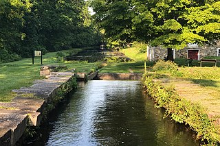
The Delaware Division of the Pennsylvania Canal, more commonly called the Delaware Canal, runs for 60 miles (97 km) parallel to the right bank of the Delaware River from the entry locks near the mouth of the Lehigh River and terminal end of the Lehigh Canal at Easton south to Bristol. At Easton, which today is the home of The National Canal Museum, the Delaware Canal also connected with the Morris Canal built to carry anthracite coal to energy starved New Jersey industries. Later, with a crossing-lock constructed at New Hope, the New Hope 'outlet lock' (1847) connected by Cable Ferry to enter at Lambertville, NJ; where it connected to a feeder navigation/canal that began at Bull's Island opposite Lumberville; which then ran over 22 miles (35 km) south along the New Jersey bank of the Delaware River through Trenton to Bordentown, the west end of the Delaware and Raritan Canal (1834) to New York City via New Brunswick. The Commonwealth of Pennsylvania built the Delaware canal to feed anthracite stone coal to energy-hungry Philadelphia as part of its transportation infrastructure building plan known as the Main Line of Public Works—a legislative initiative creating a collection of self-reinforcing internal improvements to commercial transportation capabilities.

The Lehigh Canal or the Lehigh Navigation Canal is a navigable canal, beginning at the mouth of Nesquehoning Creek on the Lehigh River in eastern Pennsylvania in the United States. It was built in two sections over a span of twenty years, beginning in 1818. The lower section spanned the distance between Easton, Pennsylvania and present-day Jim Thorpe, Pennsylvania. In Easton, the canal met the Delaware and Morris Canals, which allowed goods to be transported further up the east coast. At its height, the Lehigh Canal was 72 miles (116 km) long.

Neshanic Station is an unincorporated community located within Branchburg and extending into Hillsborough Township, Somerset County, New Jersey, United States. In 2016 most of the village was listed on the National Register of Historic Places as the Neshanic Station Historic District.
Communipaw is an unincorporated community and neighborhood located within Jersey City in Hudson County, New Jersey, United States. It is located west of Liberty State Park and east of Bergen Hill, and the site of one of the earliest European settlements in North America. It gives its name to the historic avenue which runs from its eastern end near Liberty State Park Station through the neighborhoods of Bergen-Lafayette and the West Side that then becomes the Lincoln Highway. Communipaw Junction, or simply, The Junction, is an intersection where Communipaw, Summit Avenue, Garfield Avenue, and Grand Street meet, and where the toll house for the Bergen Point Plank Road was situated. Communipaw Cove at Upper New York Bay, is part of the 36-acre (150,000 m2) state nature preserve in the park and one of the few remaining tidal salt marshes in the Hudson River estuary.

Lehigh Valley Railroad Station is a historic railway station located at Rochester in Monroe County, New York. The Lehigh Valley Railroad built the station in 1905 but stopped using the station for passenger service in the 1950s. Later the station was used as a bus terminal and then as a night club. In the 1980s the building was added to the National Register of Historic Places and today it houses the Dinosaur Bar-B-Que restaurant.
Greenville Yard is a freight rail yard in the Port of New York and New Jersey. It is located on Upper New York Bay in Jersey City, New Jersey adjacent and north of Port Jersey. Originally developed in 1904 by the Pennsylvania Railroad, it was later taken over by Conrail. It has been owned by the Port Authority of New York and New Jersey since 2010. It takes its name from the former municipality of Greenville, now part of the city.

Backwards Tunnel, also known as the Ogdensburg Railroad Arch, is located in Ogdensburg, Sussex County, New Jersey, United States. The tunnel was added to the National Register of Historic Places on December 28, 2005.
National Docks Secondary is a freight rail line within Conrail's North Jersey Shared Assets Area in Hudson County, New Jersey, used by CSX Transportation. It provides access for the national rail network to maritime, industrial, and distribution facilities at Port Jersey, the Military Ocean Terminal at Bayonne (MOTBY), and Constable Hook as well as carfloat operations at Greenville Yard. The line is an important component in the planned expansion of facilities in the Port of New York and New Jersey. The single track right of way comprises rail beds, viaducts, bridges, and tunnels originally developed at the end of the 19th century by competing railroads.

Grandin is an unincorporated community located along the border of Franklin and Union townships in Hunterdon County, New Jersey.
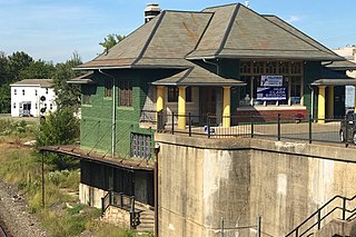
Phillipsburg Union Station is an inactive railroad station in Phillipsburg, New Jersey, United States, at 178 South Main Street. Opened in 1914, Union Station was built by the Delaware, Lackawanna & Western Railroad (DL&W) and shared with the Central Railroad of New Jersey (CNJ) and was situated where the lines merged before the bridge crossing the Delaware River. Designed by Frank J. Nies, the architect who produced many of DL&W stations now listed state and federal registers of historic places, the 2 1/2 story, 3 bay brick building is unusual example of a union station and a representation of early 20th century Prairie style architecture. The Phillipsburg Union Signal Tower, or PU Tower, is nearby.
The Waterfront Museum was formerly Lehigh Valley Barge No. 79, a Lehigh Valley Railroad barge that moved goods across the Hudson River. It dates to 1914 and is believed to be the sole all-wooden vessel built between 1860 and 1960 to remain accessible and afloat.


