
Hatfield is a town and civil parish in the City of Doncaster in South Yorkshire, England. It had a population of 17,236 at the 2011 Census. The town is located on the A18 road between Doncaster and Scunthorpe, and to the west of the M18 motorway. It shares a railway station with Stainforth on the line between Goole and Scunthorpe, and Doncaster. Recorded history in the parish extends as far back as 730, when Bede wrote about the Northumbrian King, Edwin, being killed in battle in the area.

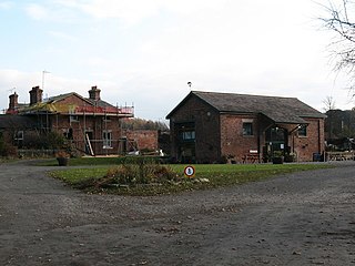
Worsbrough Mill, also known as Worsbrough Corn Mill and Worsbrough Mill Farm is a complex of buildings including a seventeenth-century water-powered mill and a nineteenth-century steam-powered mill in Worsbrough, Barnsley, England. The mill is open to the public and takes its water from the River Dove, but is hydraulically separate from Worsbrough Reservoir.
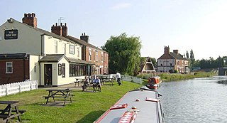
Stainforth is a town and civil parish in the City of Doncaster, in South Yorkshire, England. It is around 7 miles (11 km) north-east of Doncaster, close to Hatfield and Thorne. It had a population of 6,342 in the 2001 census, reducing slightly to 6,282 at the 2011 census.

Yorkshire Water is a water supply and treatment utility company servicing West Yorkshire, South Yorkshire, the East Riding of Yorkshire, part of North Lincolnshire, most of North Yorkshire and part of Derbyshire, in England. The company has its origins in the Yorkshire Water Authority, one of ten regional water authorities created by the Water Act 1973, and privatised under the terms of the Water Act 1989, when Yorkshire Water plc, the parent company of the Yorkshire Water business, was floated on the London Stock Exchange. The parent company was Kelda Group in 1999. In February 2008, Kelda Group was bought by a consortium of infrastructure funds.

Roundhill Reservoir is situated near Leighton Reservoir in North Yorkshire, England. It was constructed by Harrogate Corporation early in the 20th century. Water from the reservoir is fed into Yorkshire Water's grid.

Healey is a small village and civil parish in the Harrogate district of North Yorkshire, England. It is situated in the valley of the River Burn, to the immediate west of Fearby. It is about three miles west of Masham in the Nidderdale Area of Outstanding Natural Beauty. There are several holiday cottages and four Grade II Listed buildings, one of which is Healey Mill, a former corn mill.

The Colsterdale towers are a set of sighting towers in and around Colsterdale, North Yorkshire, England.

Clints Crags is a small fell in the north of the English Lake District near Blindcrake, Cumbria. It has its own chapter in Alfred Wainwright's The Outlying Fells of Lakeland. He describes a circular walk from Blindcrake, and laments that at the time of writing (1974): "This is a walk on public footpaths, but until somebody removes the barbed wire and other obstacles to legitimate progress it can be recommended only to gymnasts." It reaches 804 feet (245 m). Since the time of writing the barbed wire has been removed and the path to the summit is clear of obstructions.
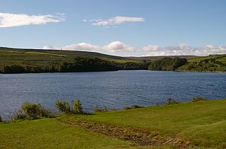
Leighton Reservoir is a reservoir which drains via the River Burn to the River Ure in North Yorkshire, England. It neighbours Roundhill Reservoir and is about 4 miles (6.4 km) west of Masham. It takes its name from the nearby village of Leighton.

Thornton Steward Reservoir is a reservoir north of the village of Thornton Steward in North Yorkshire, England. It is owned by Yorkshire Water, and supplies drinking water to Swaledale, Wensleydale, Northallerton, and Thirsk.

The Dunstable Branch Lines were railway branch lines that joined the English town of Dunstable to the main lines at Leighton Buzzard and Welwyn. The two lines were under separate ownership and joined just east of the Dunstable North station.
The Masham branch was a 7+3⁄4-mile (12.5 km) long North Eastern Railway built single track branch railway line that ran between a junction on the Harrogate to Northallerton line at Melmerby to Masham, North Yorkshire, via one intermediate station, Tanfield.

Martha Hatfield was an English Puritan prophet.

The River Burn is a river that flows wholly within North Yorkshire, England. The river starts as several small streams on Masham Moor and drains Colsterdale flowing eastwards before emptying into the River Ure just south of Masham. Conservation work on removing a weir, and introducing fish to the river in 2016, has meant that salmon have been recorded spawning in the river for the first time in over 100 years.

Upper Barden Reservoir is an upland fresh water reservoir, one of two reservoirs that collect water from Barden Moor, and dam Barden Beck, a tributary of the River Wharfe in the Yorkshire Dales, North Yorkshire, England. The reservoir was opened in 1882 and also supplies fresh water to the Nidd Aqueduct, which transports it to Bradford. Upper Barden Reservoir was the second of the reservoirs to be built,.
The South Yorkshire Way is the name for two interlinked Long Distance footpaths in the county of South Yorkshire. The Boundary Route is a 171-mile (275 km) route around the outskirts of the county, whilst the Central Route is a 98-mile (158 km) route through the heart of the county. Both trails start and end at the same points; Thorne North railway station and Dore & Totley railway station.

The Colsterdale Light Railway (CLR) was a narrow-gauge railway line in Colsterdale, North Yorkshire, England. It was built between 1903 and 1905 to allow materials to be taken up the Colsterdale valley for reservoir building. The building of two reservoirs in the valley of the River Burn, was first approved for the councils of Harrogate and Leeds respectively in 1901. Construction on the second reservoir was halted during the First World War, although the railway was kept in use carrying men and supplies to the training camp, later a PoW camp, at Breary Banks.
