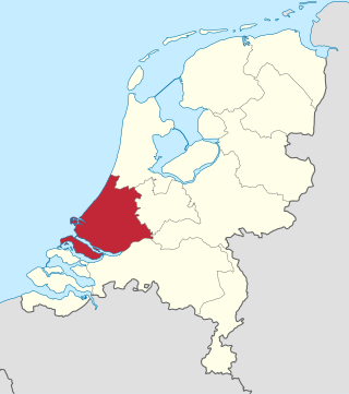
South Holland is a province of the Netherlands with a population of over 3.7 million as of October 2021 and a population density of about 1,373/km2 (3,560/sq mi), making it the country's most populous province and one of the world's most densely populated areas. Situated on the North Sea in the west of the Netherlands, South Holland covers an area of 3,307 km2 (1,277 sq mi), of which 607 km2 (234 sq mi) is water. It borders North Holland to the north, Utrecht and Gelderland to the east, and North Brabant and Zeeland to the south. The provincial capital is the Dutch seat of government The Hague, while its largest city is Rotterdam. The Rhine-Meuse-Scheldt delta drains through South Holland into the North Sea. Europe's busiest seaport, the Port of Rotterdam, is located in South Holland.
Alblasserdam is a town and municipality in the western Netherlands, in the province of South Holland. It covers an area of 10.06 km2 (3.88 sq mi), of which 1.28 km2 (0.49 sq mi) is water, and has a population of 20,069 as of 2019. Alblasserdam is officially a part of the Drechtsteden region. A portion of the small village of Kinderdijk, which boasts the largest and most famous concentration of windmills in the Netherlands, is part of Alblasserdam.

Krimpen aan den IJssel is a town and municipality in the western Netherlands, in the province of South Holland. The municipality had a population of 29,376 in 2019, and covers an area of 8.95 km2 (3.46 sq mi) of which 1.26 km2 (0.49 sq mi) is water.

Nederlek is a former municipality in the western Netherlands, in the province of South Holland. Since 2015 it has been a part of the municipality of Krimpenerwaard.

Nieuw-Lekkerland is a town in the western Netherlands, in the province of South Holland. It is situated on the southern shores of the Lek River, in the north-west of the Alblasserwaard.

Nieuwerkerk aan den IJssel is a town and former municipality in the western Netherlands, in the province of South Holland. Since 2010 it is part of the new municipality of Zuidplas.
Ridderkerk is a town and municipality in the western Netherlands, in the province of South Holland. The municipality had a population of 46,241 in 2019 and covers an area of 25.26 km2 (9.75 sq mi) of which 1.54 km2 (0.59 sq mi) is covered by water.

Schoonhoven is a city and former municipality in the western Netherlands, in the province of South Holland. Since 2015 it has been a part of the municipality of Krimpenerwaard, before it had been an independent municipality.

The Lek is a river in the western Netherlands of some 60 km (37 mi) in length. It is the continuation of the Nederrijn after the Kromme Rijn branches off at the town of Wijk bij Duurstede. The main westbound waterway is hereafter called the Lek River. The Nederrijn is, itself, a distributary branch of the river Rhine.

The Hollandse IJssel is a branch of the Rhine delta that flows westward from Nieuwegein on river Lek through IJsselstein, Gouda and Capelle aan den IJssel to Krimpen aan den IJssel, where it ends in the Nieuwe Maas. Another branch called Enge IJssel flows southwest from Nieuwegein. The name IJssel is thought to derive from the Germanic i sala, meaning "dark water". Originally, the Hollandse IJssel forked off from river Lek at Nieuwegein, but the connection was cut off with the Hollandse IJssel nowadays only draining the surrounding pastures.
The Groene Hart is a relatively thinly populated area of the Netherlands covering much of the middle portion of the Randstad megalopolis. The major Dutch cities of Rotterdam, The Hague, Leiden, Haarlem, Amsterdam and Utrecht surround this area. Cities inside the Groene Hart include Zoetermeer, Alphen aan den Rijn, Gouda, Woerden and the smaller cities of Schoonhoven, Oudewater, Haastrecht, Nieuwkoop, Montfoort, Waddinxveen, Bodegraven and Boskoop.
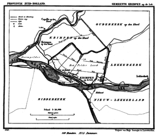
Krimpen aan de Lek is a town on the Lek River in the municipality of Krimpenerwaard, province of South Holland, the Netherlands. It had 6,607 inhabitants in 2008.

Ouderkerk aan den IJssel is a village in the municipality of Krimpenerwaard, in the province of South Holland, the Netherlands. It is situated along the river Hollandse IJssel and has over 4000 inhabitants.

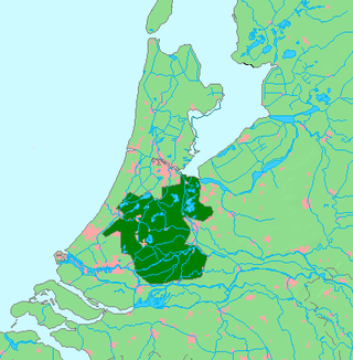
Krimpenerwaard is a municipality, a region and a former water board of the Netherlands. It is a rural area located in the east of the province of South Holland, just south of Gouda and east of the Rotterdam conurbation. It is bordered on the north by the river Hollandse IJssel, on the south by the river Lek and on the east by the stream Vlist.
Zuid-Holland Oost is an official region of the province of South Holland in the Netherlands.
De Lek was a heerlijkheid (manor) and municipality in the Netherlands, located in the province South Holland. It is named after the Lek River.

Johanna van Polanen was a Dutch noblewoman. She was the daughter of John III of Polanen, Lord of Breda, and his wife, Odilia of Salm. The House of Polanen was a side branch of the still existing House of Wassenaer.
Schielands Hoge Zeedijk, formerly called Hoogendijk is a Dutch dike in the province of South Holland that stretches from the Schie at Schiedam to the Gouwe near Gouda. Constructed in the 13th century, the dike continues to protect an area inhabited by 3 million people from flooding by the North Sea.


