
The Ring of Brodgar is a Neolithic henge and stone circle about 6 miles north-east of Stromness on the Mainland, the largest island in Orkney, Scotland. It is part of the UNESCO World Heritage Site known as the Heart of Neolithic Orkney.
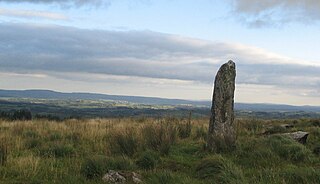
A menhir, standing stone, orthostat, or lith is a large man-made upright stone, typically dating from the European middle Bronze Age. They can be found individually as monoliths, or as part of a group of similar stones. Menhirs' size can vary considerably, but they are generally uneven and squared, often tapering towards the top.

A megalith is a large pre-historic stone that has been used to construct a structure or monument, either alone or together with other stones. There are over 35,000 in Europe alone, located widely from Sweden to the Mediterranean sea.

A stone circle is a circular alignment of standing stones. They are commonly found across Northern Europe and Great Britain, and typically date from the Late Neolithic and Early Bronze Age eras, with most concentrations appearing from 3000 BCE. The best known examples include those at the henge monument at Avebury, the Rollright Stones, and elements within the ring of standing stones at Stonehenge. Ancient stone circles appear throughout Europe, with many existing in the Pyrenees, on the Causse de Blandas in southern France in the Cevennes, in the Alps, Bulgaria, and Poland. Another type can be found in the Horn of Africa.

Alexander "Sandy" Thom was a Scottish engineer most famous for his theory of the Megalithic yard, categorisation of stone circles and his studies of Stonehenge and other archaeological sites.

The Medway Megaliths, sometimes termed the Kentish Megaliths, are a group of Early Neolithic chambered long barrows and other megalithic monuments located in the lower valley of the River Medway in Kent, South-East England. Constructed from local sarsen stone and soil between the 4th and 3rd millennia BCE, they represent the only known prehistoric megalithic group in eastern England and the most south-easterly group in Britain.

The Coffin Stone, also known as the Coffin and the Table Stone, is a large sarsen stone at the foot of Blue Bell Hill near Aylesford in the south-eastern English county of Kent. Now lying horizontally, the stone probably once stood upright nearby. Various archaeologists have argued that the stone was part of a now-destroyed chambered long barrow constructed in the fourth millennium BCE, during Britain's Early Neolithic period.

Addington Long Barrow is a chambered long barrow located near the village of Addington in the southeastern English county of Kent. Probably constructed in the fourth millennium BCE, during Britain's Early Neolithic period, today it survives only in a ruined state. Built of earth and about fifty local sarsen megaliths, the long barrow consisted of a sub-rectangular earthen tumulus enclosed by kerb-stones. Collapsed stones on the northeastern end of the chamber probably once formed a stone chamber in which human remains might have been deposited, though none have been discovered.

Kit's Coty House or Kit's Coty is a chambered long barrow near the village of Aylesford in the southeastern English county of Kent. Constructed circa 4000 BCE, during the Early Neolithic period of British prehistory, today it survives in a ruined state.

Carrowmore is a large group of megalithic monuments on the Cúil Irra peninsula near Sligo, Ireland. They were built in the 4th millennium BCE, during the Neolithic era. There are thirty surviving tombs, placing Carrowmore among the largest and oldest complexes of megalithic tombs in Ireland. It is considered one of the 'big four' along with Carrowkeel, Loughcrew and Brú na Bóinne. Carrowmore is the heart of an ancient ritual landscape which is dominated by the mountain of Knocknarea to the west. It is a protected National Monument.
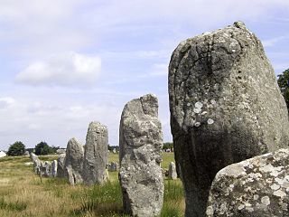
The Carnac stones are an exceptionally dense collection of megalithic sites in Brittany in northwestern France, consisting of stone alignments (rows), dolmens, tumuli and single menhirs. More than 3,000 prehistoric standing stones were hewn from local granite and erected by the pre-Celtic people of Brittany, and form the largest such collection in the world. Most of the stones are within the Breton village of Carnac, but some to the east are within La Trinité-sur-Mer. The stones were erected at some stage during the Neolithic period, probably around 3300 BCE, but some may date to as early as 4500 BCE.

Boscawen-Ûn is a Bronze Age stone circle close to St Buryan in Cornwall, UK. It consists of nineteen upright stones in an ellipse with another, leaning, middle stone just south of the centre. There is a west-facing gap in the circle, which may have formed an entrance. The elliptical circle has diameters 24.9 and 21.9 metres. It is located at grid reference SW412274.
This article describes several characteristic architectural elements typical of European megalithic structures.
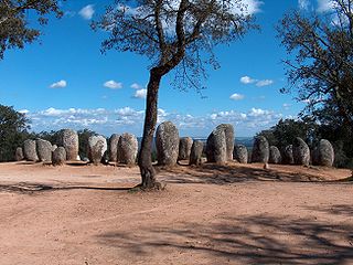
The Cromlech of the Almendres is a megalithic complex, located 4.5 road km WSW of the village of Nossa Senhora de Guadalupe, in the civil parish of Nossa Senhora da Tourega e Nossa Senhora de Guadalupe, municipality of Évora, in the Portuguese Alentejo. The largest existing group of structured menhirs in the Iberian Peninsula, this archaeological site consists of several megalithic structures: cromlechs and menhir stones, that belong to the so-called "megalithic universe of Évora", with clear parallels to other cromlechs in Evora District, such as Portela Mogos and the Vale Maria do Meio Cromlech.

Craddock Moor Stone Circle or Craddock Moor Circle is a stone circle located near Minions on Bodmin Moor in Cornwall, UK. It is situated around half a mile Northwest of The Hurlers.

Fernacre, also known as Fernacre stone circle or Fernacre circle, is a stone circle located on the slopes of the De Lank River, 1.25 miles (2.01 km) northeast of St Breward on Bodmin Moor in Cornwall in the United Kingdom.
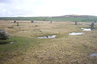
The Trippet stones or Trippet stones circle is a stone circle located on Manor Common in Blisland, 9 kilometres (5.6 mi) north northeast of Bodmin on Bodmin Moor in Cornwall, UK. The Stripple stones are nearby.

The Stripple stones is a henge and stone circle located on the south slope of Hawk's Tor, Blisland, 10 kilometres (6.2 mi) north northeast of Bodmin on Bodmin Moor in Cornwall, England, UK.

Kealkill stone circle is a bronze age axial five-stone circle located just outside the village of Kealkill, County Cork in southwest Ireland. When it was excavated in 1938 it was thought the crucial axial stone indicated an alignment to the north, contrary to the general alignment of such stone circles to the southwest. However, later archaeologists have thought it is the comparatively insignificant stone to the southwest that is the axial stone. There are two associated standing stones nearby, one of which had fallen and was re-erected in 1938.
