Lester Prairie, Minnesota

Last updated

Lester Prairie, Minnesota
McLeod County Minnesota Incorporated and Unincorporated areas Lester Prairie Highlighted.svg
Location in McLeod County and the state of Minnesota
Coordinates: 44°53′01″N94°02′14″W / 44.88361°N 94.03722°W / 44.88361; -94.03722
Country United States
State Minnesota
County McLeod
Area
[1]
  Total1.00 sq mi (2.32 km2)
  Land1.00 sq mi (2.32 km2)
  Water0.00 sq mi (0.00 km2)
Elevation
[2]
981 ft (299 m)
Population
 (2020) [3]
  Total1,894
  Density2,116.20/sq mi (817.36/km2)
Time zone UTC-6 (Central (CST))
  Summer (DST) UTC-5 (CDT)
ZIP code
55354
Area code 320
FIPS code 27-36728 [4]
GNIS feature ID2395687 [2]
Website www.lesterprairiemn.us

Lester Prairie is a city in McLeod County, Minnesota, United States, along the South Fork of the Crow River. The population was 1,894 at the 2020 census. [3]

Contents

History

Gravestone carved in German, from days when there was a large German population in Lester Prairie German gravestone in Lester Prairie, MN.jpg
Gravestone carved in German, from days when there was a large German population in Lester Prairie

Lester Prairie was platted in 1886 and named for John N. Lester, an original owner of the town site. [5] A post office has been in operation at Lester Prairie since 1888. [6] Lester Prairie was incorporated in 1888. [5]

Fire department and water tower Lester Prairie fire department and water tower.jpg
Fire department and water tower

Geography

The city is in eastern McLeod County. Minnesota State Highway 7 passes 1 mile (1.6 km) north of the city, leading west 16 miles (26 km) to Hutchinson and east 42 miles (68 km) to Minneapolis. Glencoe, the McLeod county seat, is 13 miles (21 km) to the southwest. McLeod County Roads 1, 9, and 23 are the main local routes in the community. A bike trail running east–west through the middle of town, the Dakota Rail Regional Trail, connects Lester Prairie to the Twin Cities.

According to the U.S. Census Bureau, Lester Prairie has a total area of 1.00 square mile (2.59 km2), of which 0.001 square miles (0.003 km2), or 0.1%, are water. [1] The South Fork of the Crow River, a tributary of the Mississippi River, flows past the southeast corner of the city.

Demographics

Historical population
CensusPop.Note
1890 189
1900 418121.2%
1910 4200.5%
1920 4343.3%
1930 4421.8%
1940 423−4.3%
1950 66356.7%
1960 96645.7%
1970 1,16220.3%
1980 1,2295.8%
1990 1,180−4.0%
2000 1,37716.7%
2010 1,73025.6%
2020 1,8949.5%
U.S. Decennial Census
City Hall Lester Prairie city hall.jpg
City Hall
Veterans memorial in city park Veterans memorial Lester Prairie MN.jpg
Veterans memorial in city park

2010 census

As of the census [7] of 2010, there were 1,730 people, 654 households, and 463 families living in the city. The population density was 2,011.6 inhabitants per square mile (776.7/km2). There were 704 housing units at an average density of 818.6 per square mile (316.1/km2). The racial makeup of the city was 93.9% White, 0.2% African American, 0.2% Native American, 1.1% Asian, 3.8% from other races, and 0.9% from two or more races. Hispanic or Latino of any race were 9.3% of the population.

There were 654 households, of which 37.3% had children under the age of 18 living with them, 58.0% were married couples living together, 8.0% had a female householder with no husband present, 4.9% had a male householder with no wife present, and 29.2% were non-families. 21.3% of all households were made up of individuals, and 9% had someone living alone who was 65 years of age or older. The average household size was 2.65 and the average family size was 3.11.

The median age in the city was 33.8 years. 28% of residents were under the age of 18; 7.6% were between the ages of 18 and 24; 29.3% were from 25 to 44; 23.5% were from 45 to 64; and 11.7% were 65 years of age or older. The gender makeup of the city was 49.5% male and 50.5% female.

2000 census

As of the census [4] of 2000, there were 1,377 people, 516 households, and 379 families living in the city. The population density was 1,910.4 inhabitants per square mile (737.6/km2). There were 531 housing units at an average density of 736.7 per square mile (284.4/km2). The racial makeup of the city was 97.68% White, 0.07% Native American, 0.07% Asian, 1.89% from other races, and 0.29% from two or more races. Hispanic or Latino of any race were 4.94% of the population.

There were 516 households, out of which 38.0% had children under the age of 18 living with them, 62.2% were married couples living together, 7.8% had a female householder with no husband present, and 26.4% were non-families. 22.7% of all households were made up of individuals, and 9.5% had someone living alone who was 65 years of age or older. The average household size was 2.67 and the average family size was 3.14.

In the city, the population was spread out, with 29.9% under the age of 18, 6.9% from 18 to 24, 30.2% from 25 to 44, 19.5% from 45 to 64, and 13.5% who were 65 years of age or older. The median age was 34 years. For every 100 females, there were 95.6 males. For every 100 females age 18 and over, there were 96.9 males.

The median income for a household in the city was $44,271, and the median income for a family was $52,417. Males had a median income of $35,463 versus $25,313 for females. The per capita income for the city was $18,223. About 2.9% of families and 5.1% of the population were below the poverty line, including 6.4% of those under age 18 and 5.0% of those age 65 or over.

Politics

Presidential election results
2020 Precinct Results Spreadsheet [8] 2016 Precinct Results Spreadsheet [9] 2012 Precinct Results Spreadsheet [10] 2008 Precinct Results Spreadsheet [11] 2004 Precinct Results Spreadsheet [12] 2000 Precinct Results Spreadsheet [13] 1996 Precinct Results [14] 1992 Precinct Results [15] 1988 Precinct Results [16] 1984 Precinct Results [17] 1980 Precinct Results [18] 1976 Precinct Results [19] 1968 Precinct Results [20] 1964 Precinct Results [21] 1960 Precinct Results [22]
Year Republican Democratic Third parties
2020 72.7%71926.1% 2581.2% 12
2016 69.8%61522.6% 1997.6% 67
2012 63.0%53934.5% 2952.5% 22
2008 59.8%51536.9% 3183.3% 28
2004 68.8%52929.8% 2291.4% 11
2000 58.6%36031.3% 19210.1% 62
1996 38.4% 22243.4%25118.2% 105
1992 39.1%24530.4% 19030.5% 191
1988 61.4%34438.6% 2160.0% 0
1984 70.5%40429.5% 1690.0% 0
1980 61.8%37530.0% 1769.2% 56
1976 53.2%26844.2% 2232.6% 13
1968 68.3%31929.1% 1362.6% 12
1964 62.6%27837.4% 1660.0% 0
1960 82.8%36216.9% 740.3% 1

Lester Prairie Schools

Lester Prairie is home to ISD #424 Lester Prairie Schools. The school is a K-12 school with both elementary and high school located in one building. There are approximately 400 students enrolled. Dr. Melissa Radeke is the district's superintendent. Mike Lee is the K-12 principal.

Notable people

Related Research Articles

<span class="mw-page-title-main">Lake Crystal, Minnesota</span> City in Minnesota, United States

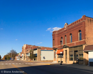
Lake Crystal is a city in Blue Earth County, Minnesota, United States, established in 1869. The population was 2,539 at the 2020 census. It is part of the Mankato-North Mankato Metropolitan Statistical Area.

Benton Township is a rural township in Carver County, Minnesota, United States. The population was 939 as of the 2000 census.

Camden Township is a rural township in Carver County, Minnesota, United States. The population was 955 as of the 2000 census.

<span class="mw-page-title-main">Hancock Township, Carver County, Minnesota</span> Township in Minnesota, United States

Hancock Township is a township in Carver County, Minnesota, United States. The population was 367 as of the 2000 census.

Hollywood Township is a rural township in Carver County, Minnesota, United States. The population was 1,102 as of the 2000 census.

Laketown Township is a township in Carver County, Minnesota, United States. The population was 2,331 as of the 2000 census.

<span class="mw-page-title-main">Farmington, Minnesota</span> City in Minnesota, United States

Farmington is a city in Dakota County, Minnesota, United States. The population was 23,632 at the 2020 census. It is a part of the Minneapolis-St. Paul metropolitan area.

<span class="mw-page-title-main">Inver Grove Heights, Minnesota</span> City in Minnesota, United States

Inver Grove Heights is a city in Dakota County, Minnesota, United States. The population was 35,801 at the 2020 census. The city was formed on March 9, 1965, with the merger of the village of Inver Grove and Inver Grove Township.

<span class="mw-page-title-main">Lakeville, Minnesota</span> City in Minnesota, United States

Lakeville is an exurb of Minneapolis-Saint Paul, and the largest city in Dakota County, Minnesota, United States. It is approximately 20 miles (32 km) south of both downtown Minneapolis and downtown St. Paul along Interstate Highway 35. Starting as a flourishing milling center, its agriculture industry and other major industries are still in operation. Lakeville is one of the fastest-growing cities in the Twin Cities area. The population was 69,490 at the 2020 census. making it Minnesota's tenth most populous city.

<span class="mw-page-title-main">Mendota Heights, Minnesota</span> City in Minnesota, United States

Mendota Heights is a city in Dakota County, Minnesota, United States. It is a first-ring southern suburb of the Twin Cities. The population was 11,744 at the 2020 census.

<span class="mw-page-title-main">Greenfield, Minnesota</span> City in Minnesota, United States

Greenfield is a city in northwestern Hennepin County, Minnesota. It has a population of 2,903 residents, according to the 2020 United States Census, and is located 26.5 miles northwest of Minneapolis. It is part of the Twin Cities Metropolitan Statistical Area.

<span class="mw-page-title-main">Long Lake, Minnesota</span> City in Minnesota, United States

Long Lake is a small city in Hennepin County, Minnesota, United States named after the lake the eastern end of town lies on. A commercial hub for the surrounding communities, Long Lake is home to many local shops and businesses. U.S. Highway 12 runs through the town. The population was 1,768 at the 2010 census.

<span class="mw-page-title-main">Glencoe, Minnesota</span> City in the United States

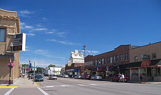
Glencoe is a city and the county seat of McLeod County, Minnesota, United States. The population was 5,744 at the 2020 census.

<span class="mw-page-title-main">Hutchinson, Minnesota</span> City in Minnesota, United States

Hutchinson is the largest city in McLeod County, Minnesota, United States. It lies along the South Fork of the Crow River. The population was 14,599 at the 2020 census.

<span class="mw-page-title-main">Montrose, Minnesota</span> City in Minnesota, United States

Montrose is a small city in Wright County, Minnesota, United States. Montrose is surrounded by farmland, prairies, and lakes. The population was 2,847 at the 2010 census.

<span class="mw-page-title-main">Arden Hills, Minnesota</span> City in Minnesota, United States

Arden Hills is a city in Ramsey County, Minnesota, United States. The population was 9,939 at the 2020 census. Bethel University and its seminary is located in the city. Also, the campus of University of Northwestern – St. Paul straddles the Arden Hills – Roseville border. The city contains the headquarters of Land O'Lakes and Catholic United Financial, a fraternal benefit society. Boston Scientific also has a large campus within Arden Hills as well.

<span class="mw-page-title-main">Howard Lake, Minnesota</span> City in Minnesota, United States

Howard Lake is a city in Wright County, Minnesota, United States. It is the host of the annual Wright county fair. The population was 1,962 at the 2010 census.

<span class="mw-page-title-main">Hastings, Minnesota</span> City in Minnesota, United States

Hastings is a city mostly in Dakota County, Minnesota, of which it is the county seat, with a portion in Washington County, Minnesota, United States. It is near the confluence of the Mississippi, Vermillion, and St. Croix Rivers. The population was 22,154 at the 2020 census. It is named for the first elected governor of Minnesota, Henry Hastings Sibley.

<span class="mw-page-title-main">Dayton, Minnesota</span> City in Minnesota, United States

Dayton is a city in Hennepin and Wright counties in the U.S. state of Minnesota. The population was 7,262 at the 2020 census. Dayton is mainly located within Hennepin County, but a part of the city extends into Wright County as well. It is the northernmost city in Hennepin County and is a suburb of the Minneapolis–St. Paul "Twin Cities" metropolitan area.

<span class="mw-page-title-main">Eagan, Minnesota</span> City in Minnesota, United States

Eagan is a city in Dakota County, Minnesota. It is south of Saint Paul and lies on the south bank of the Minnesota River, upstream from the confluence with the Mississippi River. Eagan and the other nearby suburbs form the southern section of the Minneapolis–Saint Paul area. Eagan's population was 68,855 at the 2020 census. The city was home to the headquarters of Northwest Airlines.

References

  1. 1 2 "2023 U.S. Gazetteer Files: Minnesota". United States Census Bureau. Retrieved January 11, 2024.
  2. 1 2 U.S. Geological Survey Geographic Names Information System: Lester Prairie, Minnesota
  3. 1 2 "P1. Race – Lester Prairie city, Minnesota: 2020 DEC Redistricting Data (PL 94-171)". U.S. Census Bureau. Retrieved January 11, 2024.
  4. 1 2 "U.S. Census website". United States Census Bureau . Retrieved January 31, 2008.
  5. 1 2 Upham, Warren (1920). Minnesota Geographic Names: Their Origin and Historic Significance. Minnesota Historical Society. p.  318.
  6. "McLeod County". Jim Forte Postal History. Retrieved July 19, 2015.
  7. "U.S. Census website". United States Census Bureau . Retrieved November 13, 2012.
  8. "Minnesota Secretary of State - 2020 Precinct Results Spreadsheet".
  9. "Minnesota Secretary of State - 2016 Precinct Results Spreadsheet".
  10. "Minnesota Secretary of State - 2012 Precinct Results Spreadsheet".
  11. "Minnesota Secretary of State - 2008 Precinct Results Spreadsheet".
  12. "Minnesota Secretary of State - 2004 Precinct Results Spreadsheet".
  13. "Minnesota Secretary of State - 2000 Precinct Results Spreadsheet".
  14. (PDF) https://www.lrl.mn.gov/archive/sessions/electionresults/1996-11-05-g-sec.pdf. Archived (PDF) from the original on April 10, 2021.{{cite web}}: Missing or empty |title= (help)
  15. (PDF) https://www.lrl.mn.gov/archive/sessions/electionresults/1992-11-03-g-sec.pdf. Archived (PDF) from the original on April 10, 2021.{{cite web}}: Missing or empty |title= (help)
  16. (PDF) https://www.lrl.mn.gov/archive/sessions/electionresults/1988-11-08-g-sec.pdf. Archived (PDF) from the original on April 10, 2021.{{cite web}}: Missing or empty |title= (help)
  17. (PDF) https://www.lrl.mn.gov/archive/sessions/electionresults/1984-11-06-g-sec.pdf. Archived (PDF) from the original on April 10, 2021.{{cite web}}: Missing or empty |title= (help)
  18. (PDF) https://www.lrl.mn.gov/archive/sessions/electionresults/1980-11-04-g-sec.pdf. Archived (PDF) from the original on April 10, 2021.{{cite web}}: Missing or empty |title= (help)
  19. (PDF) https://www.lrl.mn.gov/archive/sessions/electionresults/1976-11-02-g-sec.pdf. Archived (PDF) from the original on April 10, 2021.{{cite web}}: Missing or empty |title= (help)
  20. (PDF) https://www.lrl.mn.gov/archive/sessions/electionresults/1968-11-05-g-man.pdf.{{cite web}}: Missing or empty |title= (help)
  21. (PDF) https://www.lrl.mn.gov/archive/sessions/electionresults/1964-11-03-g-man.pdf.{{cite web}}: Missing or empty |title= (help)
  22. (PDF) https://www.lrl.mn.gov/archive/sessions/electionresults/1960-11-08-g-man.pdf. Archived (PDF) from the original on April 10, 2021.{{cite web}}: Missing or empty |title= (help)