
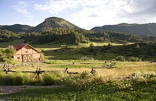
Lesterville is an unincorporated community in southeast Missouri, United States. [1] It is located in Reynolds County on Routes 21, 49, and 72 near the Black River. The ZIP Code for Lesterville is 63654. [2]
Lesterville is an unincorporated community in southeast Missouri, United States. [1] It is located in Reynolds County on Routes 21, 49, and 72 near the Black River. The ZIP Code for Lesterville is 63654. [2]
The community has the name of George Lester, a pioneer citizen. [3]
Lesterville has been the home to Camp Taum Sauk since opening in 1946. [4]
The first bank/store/post office has been reopened as a General Store and Florist now called First Dawn General Store. It was built in 1882. The building was also the site of the first electricity in Lesterville, as well as the first telephone. [5]
Lesterville R-IV School District operates two schools in the community: Lesterville Elementary School and Lesterville High School. [6]
Lesterville has a public library, a branch of the Reynolds County Library District. [7]

Wayne County is a county located in the Ozark foothills in the U.S. state of Missouri. As of the 2020 census, the population was 10,974. The county seat is Greenville. The county was officially organized on December 11, 1818, and is named after General "Mad" Anthony Wayne, who served in the American Revolution.

Reynolds County is a county located in the Ozark Foothills Region in the Lead Belt of Missouri. As of the 2020 census, the population was 6,096. Its county seat is Centerville. The county was officially organized on February 25, 1845, and was named in honor of former Governor of Missouri Thomas Reynolds.

Iron County is a county located in the Lead Belt region in the U.S. state of Missouri. As of the 2020 census, the population was 9,537. The largest city and county seat is Ironton. Iron County was officially organized on February 17, 1857, and was named after the abundance of iron ore found within its borders.

Fredericktown is a city in and the county seat of Madison County, Missouri, United States, in the northeastern foothills of the St. Francois Mountains. The population was 4,429 at the 2020 census. The city is surrounded on three sides by the easternmost parcel of the Mark Twain National Forest.

The Taum Sauk pumped storage plant is a power station in the St. Francois mountain region of Missouri, United States about 90 miles (140 km) south of St. Louis near Lesterville, Missouri, in Reynolds County. It is operated by Ameren Missouri.

Taum Sauk Mountain in the Saint Francois Mountains is the highest natural point in the U.S. state of Missouri at 1,772 feet . The topography of Taum Sauk is that of an elongated ridge with a NNW-SSE orientation rather than a peak.

The Black River is a tributary of the White River, about 300 miles (480 km) long, in southeastern Missouri and northeastern Arkansas in the United States. Via the White River, it is part of the Mississippi River watershed. Black River Technical College is named for the river.

Johnson's Shut-Ins State Park is a public recreation area covering 8,781 acres (3,554 ha) on the East Fork Black River in Reynolds County, Missouri. The state park is jointly administered with adjoining Taum Sauk Mountain State Park, and together the two parks cover more than sixteen thousand acres in the St. Francois Mountains region of the Missouri Ozarks.
Black is an unincorporated community in northern Reynolds County, Missouri, United States. It is located on Route 49 on the Middle Fork of the Black River, approximately six miles north-northeast of Centerville and southwest of Johnson's Shut-Ins State Park.

Arcadia Valley in Missouri is located 80 miles south of St. Louis in the St. Francois Mountains of the Ozark Plateau. The valley includes of the towns of Arcadia, Ironton and Pilot Knob, all founded in the 19th century.
Chromo is an unincorporated community and U.S. Post Office in Archuleta County, Colorado, United States. The Chromo Post Office has the ZIP Code 81128.
Carver Creek is a stream in Iron County in the U.S. state of Missouri. It is a tributary to Big Creek which it enters just north of the community of Sabula. The headwaters arise just south of the Taum Sauk Mountain State Park.
Claybaugh Creek is a stream in the Saint Francois Mountains of Iron County in the U.S. state of Missouri.
Palmer Creek is a stream in Iron County in the U.S. state of Missouri. It is a tributary of Big Creek.
Hyatts Creek is a stream in southwest Iron and northeast Reynolds counties in the U.S. state of Missouri. It is a tributary of the Black River.
Mayberry Branch is a stream in Reynolds County in the U.S. state of Missouri. It is a tributary of the Black River.
Peola Branch is a stream in Reynolds County in the U.S. state of Missouri. It is a tributary of the Black River. The confluence with the Black is approximately 2.5 miles south of Lesterville.
Taum Sauk Creek is a stream in Iron and Reynolds Counties in the U.S. state of Missouri.
Lesterville Township is an inactive township in Reynolds County, in the U.S. state of Missouri.
37°27′14″N90°50′36″W / 37.45389°N 90.84333°W
Municipalities and communities of Reynolds County, Missouri, United States | ||
|---|---|---|
| Cities |  | |
| Townships | ||
| Unincorporated communities | ||
| Ghost towns | ||
| Footnotes | ‡This populated place also has portions in an adjacent county or counties | |
| | This Reynolds County, Missouri state location article is a stub. You can help Wikipedia by expanding it. |