
Aberdeenshire is one of the 32 council areas of Scotland.
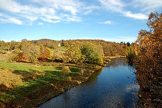
The River Don is a river in north-east Scotland. It rises in the Grampians and flows eastwards, through Aberdeenshire, to the North Sea at Aberdeen. The Don passes through Alford, Kemnay, Inverurie, Kintore, and Dyce. Its main tributary, the River Ury, joins at Inverurie.

Keith Inch is the easternmost point of mainland Scotland, having formerly been an island. It is located in Peterhead in Aberdeenshire, forming the north point of Peterhead Bay. It is now joined to Greenhill, another former island, previously separated from Keith Inch by the Poolmouth. Greenhill Road leads the motorist onto Greenhill from the town via Alexandra Parade.

Kintore is a town and former royal burgh near Inverurie in Aberdeenshire, Scotland, now bypassed by the A96 road between Aberdeen and Inverness. It is situated on the banks of the River Don.

Kincardine and Mearns is one of six area committees of the Aberdeenshire council area in Scotland. It has a population of 38,506. There are significant natural features in this district including rivers, forests, mountains and bogs.

Blackburn is a rapidly growing village northwest of Aberdeen, Scotland, and is situated in Aberdeenshire. Local amenities include an industrial estate, primary school, nursing home, Starbucks Drive Thru, local Co-op and a community hall.

Bridge of Muchalls is an entirely residential hamlet in Aberdeenshire, Scotland by the North Sea. It is next to the A92 dual carriageway about three miles north of Stonehaven and to the south of Muchalls Castle.
The Burn of Muchalls is an easterly flowing stream in Aberdeenshire, Scotland that discharges to the North Sea. Its point of discharge is on a rocky beach set with scenic sea stacks. Flowing principally over agricultural lands, the Burn of Muchalls traverses through the hamlet of the Bridge of Muchalls, flows beneath the A90 road and thence to the rugged shoreline of the North Sea slightly to the south of Doonie Point. Just above the discharge to the North Sea is a scenic pool, used in the drowning scene of Ophelia in the Franco Zeffirelli film Hamlet. A northern fork of the Burn of Muchalls flows over lands of Muchalls Castle prior to the confluence with the mainstem Burn of Muchalls within the Bridge of Muchalls.
The Burn of Pheppie is an easterly flowing coastal stream in Aberdeenshire, Scotland that discharges to the North Sea immediately north of the village of Muchalls. Draining chiefly agricultural lands, this stream has a notable lack of turbidity and a pH level of approximately 8.02. Armouring of the stream bottom consists of pebbles, many of which are quartzite in composition, leading to a golden-green effect in some locations. Other nearby watercourses discharging to the North Sea include Burn of Elsick to the north and Burn of Muchalls to the south.

Coy Burn is a stream that rises in the hills north of Banchory in Aberdeenshire, Scotland. Coy Burn discharges to the River Dee at Milton of Crathes.
Burn of Monboys is a stream that rises in the Mounth, or eastern range of the Grampian Mountains, northwest of Stonehaven and south of Netherley, Aberdeenshire, Scotland. Monboys Burn is a tributary to the Cowie Water.

The Water of Feugh (pronounced:few-ikh) is a stream in Aberdeenshire that is the largest tributary to the River Dee. This stream rises in the Grampian Mountains of Scotland, in an area known as the Forest of Birse, and has a particularly scenic aspect in a series of cascades at the Bridge of Feugh slightly above its point of discharge to the Dee.

Luther Water is a generally southerly flowing river in Aberdeenshire, Scotland that discharges into the River North Esk.
Patrick de Leuchars [also de Locrys or de Lochrys] was a 14th-century administrator and prelate in the Kingdom of Scotland. He first appears in the records in 1344 holding a church in East Lothian, and in 1351 attains national prominence as the new Bishop of Brechin. Bishop Patrick, who would be a core supporter of King David II of Scotland, became Royal Chancellor in the same decade. He held the chancellorship until around 1370, and the bishopric of Brechin until 1383, when he resigned it on account of his old age.
The Burn of Myrehouse is a coastal stream in Aberdeenshire in northeast Scotland, the lower section of which, Getty Burn is a right bank tributary of River Deveron which discharges into Banff Bay. This watercourse has been suggested as an associated feature to the prehistoric feature at nearby Longman Hill.

Banff Bay is a coastal embayment in Scotland situated between the towns of Banff, Aberdeenshire and Macduff, Aberdeenshire. The Burn of Myrehouse is one of the streams draining to Banff Bay. Banff Bay is a prominent geographical feature along the northern coast of Aberdeenshire, and it is visible from a number of locations along the coastal plain such as Longman Hill situated somewhat distant to the east.
Laeca Burn is a stream in northeastern Aberdeenshire, Scotland. There are numerous archaeological sites in the Laeca Burn watershed, "especially on the eastern side of Laeca Burn", where Catto Long Barrow is situated.

Cullerlie stone circle, also known as the Standing Stones of Echt, is a small stone circle situated near Echt, Aberdeenshire. It consists of eight irregular stones of red granite arranged at approximately equal intervals to form a circle of 10.2 m (33 ft) diameter, enclosing the same number of small cairns. The cairns are characterised by outer kerbs or rings of stones, with a double ring surrounding the central cairn and a single ring in the others. All but one of the cairns have eleven ringstones, with the last having nine. The whole circle sits on a patch of gravel which forms the end of a low gravel ridge linking the site with Leuchar Moss. It is regarded as "a later development from the recumbent stone circle", though its layout with kerbed cairns within the circle makes it unique.

Auchallater is a hamlet in Aberdeenshire, Scotland. It lies along the A93 road, to the south of Braemar.

The Water of Cruden is a short broadly east-flowing river in Buchan in northeast Scotland. Its headwaters streams rise in the countryside north of Ellon and combine to flow through the village of Hatton and onward to the village of Cruden Bay where it then enters the North Sea at the north end of the Bay of Cruden. It is crossed at various points by the A952, A90 and A975 roads. The harbour of Port Erroll stands at the point that the tidal channel enters the sea. The name Cruden is said to derive from Gaelic 'croch Dain' signifying the 'slaughter of the Danes. referencing the Battle of Cruden.
