Levittown, Puerto Rico

Last updated
Levittown
Toa baja.jpg
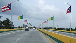
Bridge on Puerto Rico Highway 165 leaving Levittown
USA Puerto Rico location map.svg
Red pog.svg
Levittown
Location within the island of Puerto Rico
Coordinates: 18°26′55″N66°10′49″W / 18.44861°N 66.18028°W / 18.44861; -66.18028
Commonwealth Flag of Puerto Rico.svg  Puerto Rico
Area
  Total6.6 km2 (2.53 sq mi)
  Land5.9 km2 (2.27 sq mi)
  Water0.7 km2 (0.26 sq mi)
Elevation
2 m (5 ft)
Population
 (2020)
  Total25,591
  Density3,900/km2 (10,000/sq mi)
Time zone UTC-4 (Atlantic (AST))
Postal code
00949
Area code 787
FIPS code 7250260
GNIS feature ID 2414861

Levittown, a community in the San Juan MSA and part of the municipality of Toa Baja, is one of the largest planned communities in Puerto Rico. Per the 2020 census, the population was 25,591. [1]

Contents

It was developed by Levitt & Sons in 1963. Levittown is divided into eight sections called secciones (the eighth section was renamed Urb. Fronteras) and several sub-divisions called urbanizaciones. Part of what is known as Levittown is located in the municipalities of Toa Baja and Bayamon(8th Section now known as Fronteras de Bayamon). Levittown is known for its large, light blue painted water tower (now converted into a public library) that was one of the first water towers in Puerto Rico used to provide potable water to residences.[ citation needed ] To the west sits Levittown Lakes or Los Lagos de Levittown, a small man-made lake formed by draining the marshland over which Levittown was built. The drainage canal that feeds the lake is called Caño El Hato, which extends into the center of Levittown. To the east, the Bayamon River divides Levittown from the fishing village of Palo Seco, next to the Cataño municipality. To the north, Highway 165 runs along the coastline, but it has not a single official pedestrian crossing for its entire length west of the Rio Hondo, greatly impeding access to the local beaches from the residential areas.

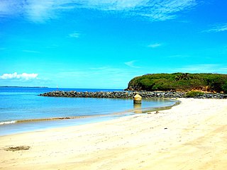
It has a Blue Flag-rated public beach known as Punta Salinas and also one of the bigger public sports centers of the metropolitan area of San Juan with tennis courts and a stadium for track and field meets. Its Olympic-sized pool has been in use since its construction in 1977. Its high school, Dr. Pedro Albizu Campos High School, was built in 1970 and is named after an important political figure on the island. The school's football team, the Levittown Spartans, have been among the top high school football teams on the island. In 1975 they became the co-champions along with the Pirates from Antilles High School, in Fort Buchanan. Also, the Spartans track teams, coached by Wilfredo Meaux (who would later on coach the team from University of Puerto Rico at Bayamon) were perennial powers during the 1970s and 80s. Levittown High's Basketball team has produced several excellent players including Ramon Rivas, who played for the NBA with the Boston Celtics. In 2018, the Levittown Baseball Team was the world champions for the first ever Colt World Series Championship, beating the Seoul, Korea team 5 -4. Colt World Series Archives

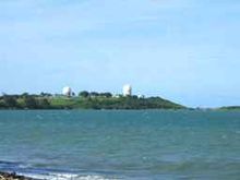
Levittown's main avenue is "Bulevar de Levittown". It has the largest collection of small business in the community. Los Dominicos Avenue is the second main avenue and connects Levittown to other areas, e.g., Sabana Seca sector and the city of Bayamón. Levittown has more than three shopping centers, including Plaza Davison and Rio Hondo Mall. Highway 165 connects Levittown with the towns of Toa Baja, Cataño and Dorado, Puerto Rico. Punta Salinas' radar domes and El Morro can be seen from this route. At night, the Morro Castle's lighthouse and the Palo Seco power plant are visible. The coastal area along the road near the Bayamon River is popular with local surfers and is known as Cochino Beach (Pigs Beach), probably because of the brownish waters caused by the sediments flowing out from the river.

Punta Salinas, the public beach, is home to a Puerto Rico Air National Guard unit, the 140 ADS, that provides air traffic control support to the FAA, military and law enforcement operations. It is also the home of a Civil Air Patrol squadron, one of several in the municipality of Toa Baja.

Levittown has tropical weather all year round. The water tower, also known by pilots as the "Levittown Water Tank" provides a visual navigational checkpoint to aircraft flying either to Isla Grande Airport or to Luis Muñoz Marín International Airport. The area around Lago De Plata suffered some flood damages due to the rising water levels during Hurricane Maria.

Transportation

Carretera PR-868, Toa Baja, Puerto Rico.jpg
Avenida Boulevard in Levittown

It is served by Route D37 of the Puerto Rico Metropolitan Bus Authority and private commuter buses connecting the community with Cataño and the Tren Urbano Rapid Transit station in Bayamon. The neighborhood is patrolled by the Toa Baja Municipal Police Department with a precinct in the western part of the neighborhood, and the 271st precinct of the Puerto Rico Police Department located behind the water tank and the high school.

Demographics

Historical population
CensusPop.Note
2010 26,960
2020 25,591−5.1%
U.S. Decennial Census [2]
2010 [3] 2020 [4]

Prior to the 2020 U.S. Census, the United States Census Bureau changed the name of the community from Levittown to Mansión del Mar. [5]

2020 census

Mansión del Mar comunidad, Puerto Rico – Demographic Profile
(NH = Non-Hispanic)
Race / EthnicityPop 2010 [3] Pop 2020 [4] % 2010% 2020
White alone (NH)2511580.93%0.62%
Black or African American alone (NH)50730.19%0.17%
Native American or Alaska Native alone (NH)200.01%0.00%
Asian alone (NH)61400.23%0.16%
Pacific Islander alone (NH)000.00%0.00%
Some Other Race alone (NH)7100.03%0.04%
Mixed Race/Multi-Racial (NH)12150.04%0.06%
Hispanic or Latino (any race)26,57725,32598.58%98.96%
Total26,96025,591100.00%100.00%

Note: the US Census treats Hispanic/Latino as an ethnic category. This table excludes Latinos from the racial categories and assigns them to a separate category. Hispanics/Latinos can be of any race.

Punta Salinas as seen from Levittown Punta salinas pr.jpg
Punta Salinas as seen from Levittown

2010 Census

As of the census of 2010, there were 26,960 people living in the community. The average family size was of 3.09. The population density was 13,279/mi2. There were 11,701 housing units. The racial makeup of the area was 73.9% White, 13.7% African American, 7.7% from other races, and 3.7% from two or more races. The majority (98.6%) were of Hispanic ethnicity. Of those, 93.5% were Puerto Rican, 0.5% Cuban, 0.3% Mexican and 4.4% of other Hispanic ethnicity.

In the community the population was 53.5% females and 46.5% males. The median age of the population was 38.4 years. The mean income for a family in the community for 2010 was $36,605. 24.2% of families were below the federal poverty level. The community was generally a lower-middle-class and working-class neighborhood. From 2008 to 2010, 81 percent of people 25 years and over had at least graduated from high school and 21.6 percent had a bachelor's degree or higher. On the average, 62.9% of its college-age population attend institutions of higher learning. 66.5 percent of Levittown workers drove to work alone in 2010, 17.4 percent carpooled, 3.7 percent took public transportation, and 11.5 percent used other means. The remaining 0.9 percent worked at home. Among those who commuted to work, it took them on average 38.0 minutes to get to work. Among the most common occupations were: Sales and office occupations, 36.1 percent; Management, professional, and related occupations, 30.0 percent; Service occupations, 17.3 percent; Production, transportation, and material moving occupations, 9.3 percent. 69.8 percent of the people employed were Private wage and salary workers; 23.5 percent was Federal, state, or local government workers; and 6.4 percent was Self-employed in own not incorporated business workers.


Notable people

See also

Related Research Articles

<span class="mw-page-title-main">San Juan, Puerto Rico</span> Capital and largest city of Puerto Rico

San Juan is the capital city and most populous municipality in the Commonwealth of Puerto Rico, an unincorporated territory of the United States. As of the 2020 census, it is the 57th-largest city under the jurisdiction of the United States, with a population of 342,259. San Juan was founded by Spanish colonists in 1521, who called it Ciudad de Puerto Rico.

<span class="mw-page-title-main">Bayamón, Puerto Rico</span> City and municipality in Puerto Rico

Bayamón is a city, municipality of Puerto Rico and suburb of San Juan located in the northern coastal valley, north of Aguas Buenas and Comerío; south of Toa Baja and Cataño; west of Guaynabo; and east of Toa Alta and Naranjito. Bayamón is spread over 11 barrios and Bayamón Pueblo. It is part of the San Juan-Caguas-Guaynabo Metropolitan Statistical Area and the second most populous municipality in both the metropolitan area and Puerto Rico.

<span class="mw-page-title-main">Cataño, Puerto Rico</span> Town and municipality in Puerto Rico

Cataño is a town and municipality located on the northeastern coast of Puerto Rico, bordering the San Juan Bay and the Atlantic Ocean, and adjacent to the north and east by San Juan; north of Bayamón and Guaynabo; east of Toa Baja and west of Guaynabo and is part of the San Juan Metropolitan Area. Cataño is spread over 7 barrios and Cataño Pueblo. It is part of the San Juan-Caguas-Guaynabo Metropolitan Statistical Area.

<span class="mw-page-title-main">Dorado, Puerto Rico</span> Town and municipality in Puerto Rico

Dorado is a town and municipality in the northern coast of Puerto Rico, 15 miles (24 km) west of San Juan and is located in the northern region of the island, bordering the Atlantic Ocean, north of Toa Alta, east of Vega Alta, and west of Toa Baja. Dorado is subdivided into five barrios and Dorado Pueblo. It is part of the San Juan-Caguas-Guaynabo Metropolitan Statistical Area. During the early 18th century, there were already mentions of a "Sitio de Dorado" in some San Juan registers. Since the beginning of the Spanish colonial period and until 1831, Dorado existed as a barrio of the town of Toa Baja. Over several years, the ward grew and established its own town center called the "new pueblo" to differentiate itself from Toa Baja, which became known as the "old pueblo." Over several years, the barrios that currently make up Dorado grew and the people of the "new pueblo" wanted to separate themselves from Toa Baja.

<span class="mw-page-title-main">Guaynabo, Puerto Rico</span> City and municipality in Puerto Rico

Guaynabo is a city, suburb of San Juan and municipality in the northern part of Puerto Rico, located in the northern coast of the island, north of Aguas Buenas, south of Cataño, east of Bayamón, and west of San Juan. Guaynabo is spread over 9 barrios and Guaynabo Pueblo. Guaynabo is considered, along with its neighbors – San Juan and the municipalities of Bayamón, Carolina, Cataño, Trujillo Alto, and Toa Baja – to be part of the San Juan metropolitan area. It is also part of the larger San Juan-Caguas-Guaynabo Metropolitan Statistical Area,.

<span class="mw-page-title-main">Rincón, Puerto Rico</span> Town and municipality in Puerto Rico

Rincón is a popular beach town and municipality of Puerto Rico founded in 1771 by Don Luis de Añasco, who previously founded Añasco in 1733. It is located in the Western Coastal Valley, west of Añasco and Aguada. Rincón is spread over 9 barrios and Rincón Pueblo. It is part of the Aguadilla-Isabela-San Sebastián Metropolitan Statistical Area.

<span class="mw-page-title-main">Toa Alta, Puerto Rico</span> Town and municipality in Puerto Rico

Toa Alta is a town and municipality of Puerto Rico located in the northern coast of the island, north of Naranjito; south of Dorado and Toa Baja; east of Vega Alta and Corozal; and west of Bayamón. Toa Alta is spread over eight barrios and Toa Alta Pueblo. It is part of the San Juan-Caguas-Guaynabo metropolitan statistical area. There are nine barrios in Toa Alta and altogether in 2020 had a population of 66,852. Río de la Plata, is a large river that runs through Toa Alta. Toa Alta celebrates its patron saint festival in May.

<span class="mw-page-title-main">Toa Baja, Puerto Rico</span> Town and municipality in Puerto Rico

Toa Baja is a town and municipality of Puerto Rico located in the northern coast, north of Toa Alta and Bayamón; east of Dorado; and west of Cataño. Toa Baja is spread over five barrios, including Toa Baja Pueblo. Toa Baja is part of the San Juan-Caguas-Guaynabo Metropolitan Statistical Area. Toa Baja is located fifteen minutes by car from San Juan and two hours from Ponce.

<span class="mw-page-title-main">Vega Alta, Puerto Rico</span> Town and municipality in Puerto Rico

Vega Alta is a town and municipality of Puerto Rico. Vega Alta is on the northern coast of the island, north of Morovis and Corozal; east of Vega Baja; and west of Dorado with an area of 28 square miles (73 km2). Vega Alta is subdivided into seven barrios and Vega Alta barrio-pueblo. It is part of the San Juan-Caguas-Guaynabo Metropolitan Statistical Area.

Julita Ross was a singer of Puerto Rican danzas, also known as "The Great Lady of the Danzas".

<span class="mw-page-title-main">Puerto Rico Highway 167</span> Highway in Puerto Rico

Puerto Rico Highway 167 (PR-167) is one of the main highways in the San Juan–Caguas–Guaynabo metropolitan area of Puerto Rico. Highway 167 starts at Puerto Rico Highway 165 in Levittown and goes until Puerto Rico Highway 156 in Comerío.

<span class="mw-page-title-main">San Juan–Caguas–Guaynabo metropolitan area</span> Metropolitan area in Puerto Rico

The San Juan metropolitan area is a United States Census Bureau defined metropolitan statistical area (MSA) in northeastern Puerto Rico centered around the city of San Juan. A July 1, 2009, Census Bureau estimate placed the population at 2,617,089, a 4.31% increase over the 2000 census figure of 2,509,007.

<span class="mw-page-title-main">Puerto Rico Firefighters Corps</span> Puerto Rico Fire Department

The Puerto Rico Firefighters Corps (PRFC); is the statewide fire department that provides fire protection, rescue, and protection from other hazards in the U.S. Estado Asociado Libre of Puerto Rico. It was established in 1942 under the Puerto Rico Fire Services. In addition, it offers fire protection services to all the airports under the authority of the Puerto Rico Ports Authority, Rafael Hernández Airport, and Mercedita Airport and they serve as crash rescue divisions. A separate agency, the Puerto Rico Medical Emergency Corps, provides emergency medical services to all Puerto Rico.

<span class="mw-page-title-main">2009 Cataño oil refinery fire</span> Explosion and fire in Bayamón, Puerto Rico

The 2009 Cataño oil refinery fire, also known as the CAPECO explosion, was a fire that began with an explosion on October 23, 2009, and was extinguished on October 25 at the Caribbean Petroleum Corporation (CAPECO) oil refinery and oil depot in Bayamón, Puerto Rico. While the fire and subsequent explosion occurred close to the city of Cataño, it technically occurred within the borders of Bayamón, even though Cataño was more affected by fumes and evacuation. There were no fatalities, but 3 people were injured.

<span class="mw-page-title-main">Puerto Rico Senatorial district II</span> Profile and election results

Puerto Rico Senatorial District II, also known as the Senatorial District of Bayamón, is one of the eight senatorial districts of Puerto Rico. It is currently represented by Migdalia Padilla and Carmelo Ríos Santiago.

<span class="mw-page-title-main">Sabana Seca</span> Barrio of Toa Baja, Puerto Rico

Sabana Seca is a barrio in the municipality of Toa Baja, Puerto Rico. Its population in 2010 was 53,192.

<span class="mw-page-title-main">Puerto Rico Highway 869</span> Highway in Puerto Rico

Puerto Rico Highway 869 (PR-869) is a north–south road located in Cataño, Puerto Rico. It begins at its intersection with PR-5 and PR-22 near Bayamón municipal limit and ends at its junction with PR-165 near Toa Baja municipal limit.

References

  1. "Mansión del Mar comunidad, Puerto Rico". United States Census Bureau . Retrieved April 15, 2022.
  2. "Decennial Census of Population and Housing by Decades". US Census Bureau.
  3. 1 2 "P2 HISPANIC OR LATINO, AND NOT HISPANIC OR LATINO BY RACE – 2010: DEC Redistricting Data (PL 94-171) – Levittown CDP comunidad, Puerto Rico". United States Census Bureau .
  4. 1 2 "P2 HISPANIC OR LATINO, AND NOT HISPANIC OR LATINO BY RACE – 2020: DEC Redistricting Data (PL 94-171) – Mansión del Mar comunidad, Puerto Rico". United States Census Bureau .
  5. "2020 Geography Changes". United States Census Bureau . Retrieved May 15, 2022.