
Anuradhapura is a major city located in the north central plain of Sri Lanka. It is the capital city of North Central Province and the capital of Anuradhapura District. The city lies 205 kilometers (127 mi) north of the current capital of Colombo in the North Central Province, on the banks of the historic Malwathu Oya. The city is now a World Heritage Site famous for its well-preserved ruins of the ancient Sinhalese civilisation.
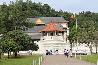
Kandy is a major city in located in the Central Province of Sri Lanka. It was the last capital of the Sinhalese monarchy from 1469 to 1818, under the Kingdom of Kandy. The city is situated in the midst of hills in the Kandy plateau, which crosses an area of tropical plantations, mainly tea. Kandy is both an administrative and religious city and the capital of the Central Province. Kandy is the home of the Temple of the Tooth Relic, one of the most sacred places of worship in the Buddhist world. It was declared a World Heritage Site by UNESCO in 1988. Historically the local Buddhist rulers resisted Portuguese, Dutch, and British colonial expansion and occupation.

Hatton is a major town in the Nuwara Eliya District of Central Province, Sri Lanka governed by the Hatton-Dickoya Urban Council. Hatton is a major centre of the Sri Lankan tea industry.

Batticaloa is a major city in the Eastern Province, Sri Lanka, and its former capital. It is the administrative capital of the Batticaloa District. The city is the seat of the Eastern University of Sri Lanka and is a major commercial centre. It is on the east coast, 111 kilometres (69 mi) south of Trincomalee, and is situated on an island. Pasikudah is a popular tourist destination situated 35 km (22 mi) northwest with beaches and flat year-round warm-water shallow-lagoons.
Ratnapura is a major city in Sri Lanka. It is the capital city of Sabaragamuwa Province, as well as the Ratnapura District, and is a traditional centre for the Sri Lankan gem trade. It is located on the Kalu Ganga in south-central Sri Lanka, some 101 km (63 mi) southeast of the country's capital, Colombo. Ratnapura is also spelled as Rathnapura.

Badulla is the capital and the largest city of Uva Province situated in the lower central hills of Sri Lanka. It is the capital city of Uva Province and the Badulla District.

Matara is a major city in Sri Lanka, on the southern coast of Southern Province. It is the second largest city in Southern Province. It is 160 km (99 mi) from Colombo. It is a major commercial hub, and it is the administrative capital and largest city of Matara District.

Dharmaraja College, founded in 1887, is a boys' school in Kandy, Sri Lanka. It is a Buddhist school with around 300+ teaching staff and over 4,000+ students. The school has many notable alumni including the first President of Sri Lanka William Gopallawa, A. E. Goonesinha, T.B Kehelgamuwa, Chamara Kapugedera, Sudarshana Pathirana and others.

The Kingdom of Kandy was a monarchy on the island of Sri Lanka, located in the central and eastern portion of the island. It was founded in the late 15th century and endured until the early 19th century.

Gampola is a town located in Kandy District, in Sri Lanka's Central Province. The town is governed by an Urban Council. Gampola was made the capital of the island by King Buwanekabahu IV, who ruled for four years in the mid-fourteenth century. The last king of Gampola was King Buwanekabahu V, who ruled the island for 29 years. A separate city was built in Kotte during this time by a noble known as Alagakkonara. The longest sleeping Buddha statue in South Asia is located in the Saliyalapura Temple, Gampola.
Bahirawakanda is a village in the centre of the Kandy, Sri Lanka. In Sinhala, Bahirawa Kanda translates to mountain of Bahirawa. According to Sri Lankan myths, Bahirawa is a sanguinary deity associated with earth and territory protection.
Danture is a village in Sri Lanka. It is located within Central Province. It is located about 20 kilometers from Kandy, the former capital of the country. Danthure is known for its historical significance, as it was the site of a major battle between the Portuguese and the Kandyans in 1594. The Kandyans were victorious in this battle, which is considered a turning point in the indigenous resistance to Portuguese expansion.
Digana, Central Province, Sri Lanka.
Hataraliyadda is a village in Sri Lanka. It is located within Central Province in Kandy district. Hataraliyadda is a intrechange of roads to Galagedara, Muruthalawa, Rambukkana and Mawathagama. Hataraliyadda is about 18 km away from Nelligala International Buddhist Temple.
Suduhumpola is a village in Sri Lanka. It lies 1.5 miles from Kandy on the foothills of the Hanthana Mountain Range, within Kandy District, Central Province.

Katugastota is a suburb of the city of Kandy in Kandy District, Central Province of Sri Lanka. It is located along the Kandy-Jaffna A9 highway approximately 4 km (2.5 mi) from the city center of Kandy. Katugastota is one of the three main entry points to the city of kandy. Two major Highways meet at the center of the city which makes Katugastota one of the busiest suburbs in Kandy district.
Naula is a small town in Sri Lanka. It is located within Matale district, Central Province. It is located in A9 road (Kandy-Jaffna) about 53 kilometers from Kandy. It is situated in an intermediate climate zone. The roads in the vicinity of Naula are known for picturesque scenery. Tourist attractions in the area include Bowathenna Dam, tank & Power station, Nalanda Gedige, Nalanda tank and the Nitre caves.
Pilawala is a village in Kandy, Sri Lanka. It is located within the Central Province, about 9 km easterly from Kandy. There is an Access route via Sirimalwatta - Yakgahapitiya - Menikhinna road or by the Shuttle Bus route Number 621, Menikhinna - Kandy.
West Watta is a village in Sri Lanka. It is located within Central Province, slightly southeast. The A2 road runs through the village; it is close to the Kinkini Wehera Raja Maha Viharaya Buddhist Temple and next to the Kirindi Oya River.

The 1998 Temple of the Tooth attack was an attack on the Temple of the Tooth Relic, located in Kandy, Sri Lanka. The shrine, which is considered to be important to the Buddhists in Sri Lanka, houses the relic of the tooth of the Buddha, and is also a UNESCO designated World Heritage Site. In 1998, it was attacked by Liberation Tigers of Tamil Eelam (LTTE), a separatist militant organization which fought to create an independent Tamil state in Northern and Eastern parts of the country, from 1983 to 2009.
