Lezama Park

Last updated
The barranca along the park's eastern half Buenos Aires - San Telmo - Parque Lezama - 20071215d.jpg
The barranca along the park's eastern half
Gazebo and sculpture garden Lezama St012.jpg
Gazebo and sculpture garden

Lezama Park is a public park in the San Telmo district of Buenos Aires, Argentina.

Contents

Overview

Historians believe the park's eastern barranca to have been the site of Spanish Conquistador Pedro de Mendoza's landing on what became the first, failed attempt to establish Buenos Aires in 1536. Well to the south of the colonial hamlet, the land was first purchased by Manuel Gallego y Valcárcel around 1790. The lot was later purchased by a succession of English Argentines, the last of whom, Charles Ridgley Horne, improved and expanded the property, raising a baroque mansion on the land's western edge, Defensa Street. Allied to the repressive paramount Governor of Buenos Aires, Juan Manuel de Rosas, Ridgley Horne was forced into exile after the strongman's 1852 overthrow, however, and the land was sold to José Gregorio Lezama, who added adjoining lots to the north and gave the green space its current dimensions.

Lezama commissioned Belgian landscape designer Charles Veerecke to beautify the grounds, planting rows of tipa and jacaranda trees decades before the three species became nearly emblematic of the city at large. Following his 1894 passing, Lezama's widow sold the 8 hectare (20 acre) estate to the city for a token sum, on condition that the grounds become a park in her late husband's name. The couple's Defensa Street mansion became the Argentine National Museum of History in 1897 and the Municipal Parks Director, the noted French Argentine urbanist Carlos Thays, remodeled the park with gates, a rose garden, a gazebo, a pergola, a sculpture garden and an esplanade in 1904.

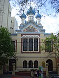
The park's surroundings were enhanced by the 1901 inaugural of the Russian Orthodox Church of Buenos Aires and by the addition of a number of buildings in the Second Empire style, notably the one housing the Bar Británico, an English-style Pub still popular among locals. The Canale Biscuit Company factory, a leading neighborhood employer when it opened in 1910, was converted into an arts and commercial complex in 2006.

The 1930s saw the removal of the perimeter gates, as well as the addition of monuments such as the one to Pedro de Mendoza. Lezama Park began to show its age in recent decades, a development dramatized by the theft of a number of the park's many decorative urns and bronzes. Mayor Mauricio Macri announced works to restore the park in 2008. The plan included the reintroduction of perimeter gates modeled on the originals and the addition of a solarium, among other new features. Delays in its implementation, coupled with the growing number of street vendors, continued to blight the park, however.

Images from the park

Monument to Pedro de Mendoza Parque Lezama-Monumento Mendoza-HDR.jpg
Monument to Pedro de Mendoza
Steps along the barranca Buenos Aires - San Telmo - Parque Lezama.jpg
Steps along the barranca
Artists' fair and playground (SW) Buenos Aires - San Telmo - Parque Lezama - 20071215e.jpg
Artists' fair and playground (SW)

Facing the park

Coordinates: 34°37′36″S58°22′10″W / 34.62667°S 58.36944°W / -34.62667; -58.36944

Related Research Articles

San Telmo, Buenos Aires Neighborhood of Buenos Aires in C1, Argentina

San Telmo is the oldest barrio (neighborhood) of Buenos Aires, Argentina. It is a well-preserved area of the Argentine metropolis and is characterized by its colonial buildings. Cafes, tango parlors and antique shops line the cobblestone streets, which are often filled with artists and dancers. A street named the "Illuminated Block" is where many of these important historical buildings can be found.

<i>Casa Rosada</i> Office building of the President of Argentina in Olivos, Buenos Aires

The Casa Rosada is the office of the president of Argentina. The palatial mansion is known officially as Casa de Gobierno. Normally, the president lives at the Quinta de Olivos, the official residence of the president of Argentina, which is located in Olivos, Greater Buenos Aires. The characteristic color of the Casa Rosada is baby pink, and is considered one of the most emblematic buildings in Buenos Aires. The building also houses a museum, which contains objects relating to former presidents of Argentina. It has been declared a National Historic Monument of Argentina.

La Chacarita Cemetery National Cemetery of Argentinia

Cementerio de la Chacarita in Buenos Aires, Argentina, is known as the National Cemetery and is the largest in Argentina.

La Boca is a neighborhood (barrio) of the Argentine capital, Buenos Aires. It retains a strong Italian flavour, with many of its early settlers being from the city of Genoa.

Belgrano, Buenos Aires Neighborhood of Buenos Aires in C13, Argentina

Belgrano is a northern and leafy barrio or neighborhood of Buenos Aires, Argentina.

Viceroyalty of the Río de la Plata Colonial state within the Spanish Empire in South America (1776-1825)

The Viceroyalty of the Río de la Plata meaning "River of the Silver", also called "Viceroyalty of the River Plate" in some scholarly writings, in southern South America, was the last to be organized and also the shortest-lived of the Viceroyalties of the Spanish Empire in the Americas. The name "Provincias del Río de la Plata" was formally adopted in 1810 during the Cortes of Cádiz to designate the Viceroyalty of the Río de la Plata

Departments form the second level of administrative division, and are subdivided in municipalities. They are extended in all of Argentina except for the Province of Buenos Aires and the Autonomous City of Buenos Aires, the national capital, each of which has different administrative arrangements.

San Nicolás, Buenos Aires Neighborhood of Buenos Aires in C1, Argentina

San Nicolás is one of the neighbourhoods of Buenos Aires, Argentina, sharing most of the city and national government Neighborhood of Buenos Aires with neighboring Montserrat and home to much of the financial sector. It's referred usually as El Centro, and the part east of the 9 de Julio Avenue is known as Microcentro.

Morón, Buenos Aires City in Buenos Aires, Argentina

Morón is a city in the Argentine province of Buenos Aires, capital of the Morón partido, located in the Greater Buenos Aires metropolitan area, at 34°39′S58°37′W. Located 20 km (13 mi) west of Downtown Buenos Aires, Morón is easily reached via bus along Avenida Rivadavia, via National Highway 7, and the Sarmiento railway line.

Argentine Declaration of Independence 1816 proclamation of independence of the United Provinces of South America from Spain

What today is commonly referred as the Independence of Argentina was declared on July 9, 1816, by the Congress of Tucumán. In reality, the congressmen who were assembled in Tucumán declared the independence of the United Provinces of South America, which is one of the official names of the Argentine Republic. The Federal League Provinces, at war with the United Provinces, were not allowed into the Congress. At the same time, several provinces from the Upper Peru that would later become part of present-day Bolivia, were represented at the Congress.

National Historical Museum (Argentina) Museum in Buenos Aires, Argentina

The Argentine National Historical Museum is located in Buenos Aires, Argentina, and is a museum dedicated to the history of Argentina, exhibiting objects relating to the May Revolution and the Argentine War of Independence.

Barracas, Buenos Aires Neighborhood of Buenos Aires in C4, Argentina

Barracas is a barrio, or district, in the southeast part of the city of Buenos Aires, Argentina. It is located between the railroad of Ferrocarril General Manuel Belgrano and the Riachuelo River, and the streets Regimiento de Patricios, Defensa, Caseros, Vélez Sársfield, Amancio Alcorta, Lafayette, and Lavardén. The name Barracas comes from the word barraca, which refers to a temporary construction of houses using rudimentary materials.

Avenida Coronel Díaz Street in Buenos Aires, Argentina

Coronel Díaz Avenue is an avenue that marks the limit between the Palermo and Recoleta neighborhoods in Buenos Aires, Argentina, and extends northbound, parallel Pueyrredón Avenue. It starts on Soler Street and ends on Castex Street, passing along Las Heras Park and the nearby Alto Palermo Shopping Center.

Avenida Rivadavia Street in Buenos Aires, Argentina

Avenida Rivadavia is one of the principal thoroughfares in Buenos Aires, Argentina, extending 23 miles (37 km) from downtown Buenos Aires to the western suburb of Merlo.

Congressional Plaza

Congressional Plaza is a public park facing the Argentine Congress in Buenos Aires. The plaza is part of a 3 hectare open space comprising three adjoining plazas to the east of the Congress building. The Kilometre Zero for all Argentine National Highways is marked on a milestone at the Plaza.

Quinta de Olivos Official residence of the President of Argentina in Buenos Aires

The Quinta presidencial de Olivos, also known as Quinta de Olivos, is an architectural landmark in the north side Buenos Aires suburb of Olivos and the official residence of the President of Argentina. It is one of the President's official residences.

Adolfo Carranza

Adolfo Carranza was an Argentine lawyer, public official, historian, and writer who established the National Historical Museum.

Hospital Británico de Buenos Aires

Hospital Británico de Buenos Aires is a hospital in Buenos Aires, Argentina.

Cathedral of the Most Holy Trinity, Buenos Aires

The Russian Orthodox Cathedral of the Most Holy Trinity is an Eastern Orthodox church building in Buenos Aires, Argentina. Located in the neighborhood of San Telmo, in front of Lezama Park.