Li County, Gansu

Last updated
Li County
礼县
Location of Longnan Prefecture within Gansu (China).png
Coordinates: 34°06′03″N104°58′37″E / 34.10083°N 104.97694°E / 34.10083; 104.97694
Country China
Provinces Gansu
Prefecture-level city Longnan
County seatChengguan
Area
  Total4,299.92 km2 (1,660.21 sq mi)
Population
 (2017)[ citation needed ]
  Total536,817
  Density120/km2 (320/sq mi)
Time zone China Standard
Postal code
742200
Area code 0939
Licence plate prefixes K
Website lixian.gsjgbz.gov.cn

Li County or Lixian is an administrative division of the prefecture-level city of Longnan in southeastern Gansu, a northwestern province of China. The 2010 Chinese census found a population of 458,237, a decline of around 25,000 from the year 2000 but still placing it second in size within its prefecture. [1]

Contents

The county seat is also known as Lixian, formerly romanized as Li Hsien. It is located at the confluence of the Western Han and Yanzi rivers, tributaries of the Jialing and Yangtze watersheds. Commanding a valley connecting the Yellow and Yangtze river systems, it was an important outpost of the Shang and Zhou dynasties and was the initial seat of the Ying family who later established the kingdom and empire of Qin.

Geography

Lixian is bordered within Longnan by the counties of Xihe to the east, Wudu to the south, and Tanchang to the west. The municipalities of Dingxi and Tianshui lie to the northwest and northeast, respectively.

Sir Eric Teichman, the British diplomat and orientalist, described the territory in 1916 before its modern development:

...the path [from Tianshui] crosses the Tsin-ling Shan, and passes from the basin of the Huang Ho into that of the Yang-tse by an easy pass. The south-eastern corner of Kan-su, south of the Tsin-ling Shan range, differs greatly from the rest of the province. The bare loess hills of Central Kan-su with their waterless valleys give way to jungle-covered mountains with abundance of water, and coolie transport takes the place of camels, carts, and mules. The people are in close touch with Sechuan. [2]

The Liba gold deposit (李坝金矿区) lies within the county limits. [3]

Climate

Climate data for Lixian (1991–2020 normals, extremes 1981–2010)
MonthJanFebMarAprMayJunJulAugSepOctNovDecYear
Record high °C (°F)15.3
(59.5)
20.2
(68.4)
28.1
(82.6)
31.0
(87.8)
32.0
(89.6)
34.2
(93.6)
35.5
(95.9)
34.1
(93.4)
33.5
(92.3)
26.3
(79.3)
20.2
(68.4)
14.8
(58.6)
35.5
(95.9)
Mean daily maximum °C (°F)4.0
(39.2)
7.3
(45.1)
12.9
(55.2)
19.0
(66.2)
22.8
(73.0)
26.1
(79.0)
28.1
(82.6)
27.1
(80.8)
21.6
(70.9)
16.1
(61.0)
10.8
(51.4)
5.5
(41.9)
16.8
(62.2)
Daily mean °C (°F)−2.0
(28.4)
1.5
(34.7)
6.6
(43.9)
12.1
(53.8)
16.0
(60.8)
19.6
(67.3)
22.0
(71.6)
21.1
(70.0)
16.5
(61.7)
10.9
(51.6)
4.8
(40.6)
−0.9
(30.4)
10.7
(51.2)
Mean daily minimum °C (°F)−6.3
(20.7)
−2.7
(27.1)
1.6
(34.9)
6.3
(43.3)
10.2
(50.4)
14.1
(57.4)
17.0
(62.6)
16.6
(61.9)
12.8
(55.0)
7.2
(45.0)
0.7
(33.3)
−5.2
(22.6)
6.0
(42.8)
Record low °C (°F)−17.7
(0.1)
−15.3
(4.5)
−9.9
(14.2)
−4.1
(24.6)
−0.8
(30.6)
5.2
(41.4)
8.2
(46.8)
7.6
(45.7)
2.6
(36.7)
−5.3
(22.5)
−11.9
(10.6)
−16.7
(1.9)
−17.7
(0.1)
Average precipitation mm (inches)4.6
(0.18)
6.5
(0.26)
18.9
(0.74)
36.0
(1.42)
61.2
(2.41)
65.1
(2.56)
80.4
(3.17)
78.6
(3.09)
69.5
(2.74)
48.3
(1.90)
8.9
(0.35)
2.4
(0.09)
480.4
(18.91)
Average precipitation days (≥ 0.1 mm)5.45.58.29.211.611.911.711.613.212.15.62.9108.9
Average snowy days10.58.64.30.7000000.32.75.732.8
Average relative humidity (%)65646362656971737879756869
Mean monthly sunshine hours 143.7124.6151.0179.4189.2170.1175.9167.0106.2106.3127.1149.41,789.9
Percent possible sunshine 45404046444040412931414941
Source: China Meteorological Administration [4] [5]

Agriculture

Huaniu apples are a speciality agricultural product of the region. [6]

History

Scientists from Lanzhou University have established that widespread agriculture began in Li County around 6,400 years ago as part of the Banpo phase of the Yangshao culture of the Wei River valley. The warm, humid climate of the mid-Holocene made the area productive for millet prior to the drier conditions which began about 2000BC. [7]

By the time of ancient China, Lixian was part of the territory of Xichui (lit. "the Western March"). [8] During the Shang dynasty, Zhongjue [10] and his son Feilian (蜚廉) controlled Xichui from the midst of the area's Rong tribes. Feilian's son Elai served King   Zhou as his bodyguard and was killed when King Wu overthrew him and founded the Zhou dynasty. [11]

Under the Zhou, however, Elai's familythe House of Ying continued to control the area. His great-great-grandson was Daluo (大骆), who had two sons by different mothers in the early 9th centuryBC. [11] Cheng, his son by the daughter of the Marquis of Shen, inherited Xichui and the other son, Feizi, initially went without and served as his brother's horse breeder. [12] His reputation grew to the point that King  Xiao charged him with breeding and providing the imperial cavalry. He proved so successful that, when the Marquis of Shen blocked his inheritance of Daluo's estate, King Xiao created him lord of nearby Qin (present-day Zhangjiachuan, Gansu). [8] During the 842BC Compatriots Rebellion, the Zhou king Li was overthrown at Hao and forced into a prolonged exile; [14] the Rong took the occasion to attack and massacre Cheng's clan at Xichui. King Xuan named Feizi's great-grandson Qin Zhong commander over the Zhou expeditions against the Rong around 827BC [11] but the Rong killed him at Qin in 822. His son Zhuang and his four younger brothers successfully invaded the Rong lands with 7,000 Zhou soldiers and recovered both Qin and Xichui. [8]

At some point during Spring and Autumn period, barley and wheat were introduced into the area in addition to its traditional millet. [7] Created a duke over Xichui, Zhuang moved his family's capital to the site, [11] [12] establishing the city of Quanqiu. [8] When Zhuang died in 778BC, his eldest son Shifu (世父) refused to inherit official duties but chose instead to live a life on his chariot, fighting the Rong in revenge for his grandfather's death. [11] [12] His younger brother Xiang opted to marry his sister Mu Ying to King Feng of the Rong (豐王) and, the next year in 776BC, he moved his capital from Quanqiu to Qian (, present-day Longxian in Shaanxi). [12] Shifu led the defense of Quanqiu against the Rong who subsequently invaded. Overcome, he was captured and lived among the Rong for a year before being released. [11] When the Quanrong overcame Hao in 771 and ended the Western period of the Zhou, Xiang was granted a promotion by King Ping and no longer suffered subordinate status. [12]

Under the Qin and Han dynasties, it was part of Longxi Commandery, headquartered at Didao (present-day Taoyang in Lintao County). During the Northern Wei dynasty, it was part of Hanyang Commandery, headquartered at Hanyang (present-day Tianshui). Under the Western Wei, this was changed to Hanyang County. During the Tang, Lixian was known as Changdao (長道, 长道) and was part of Qinzhou (秦州), a province centered variously at Shanggui (present-day Tianshui) and Chengji (present-day Qin'an). [15] The area was the home of the noted 10th-century memoirist Wang Renhui (王仁裕). [15] Li County was separated from Tianshui's jurisdiction during the ninth year of Chenghua (AD1473) during the Ming dynasty.

Li County's loess is prone to erosion and landslides. Amid the increasing collectivization of agriculture from 1964 to 1978, just seven flows damaged 22,000 hectares (85 sq mi) of farmland, destroyed 17,544 homes, and killed 1,142 people. [16]

During the Cultural Revolution, the area received a bit of local notoriety for its flagging grain production. The "experiences of Li County" were used by regional officials to caution against implementation of Tachai-style collectivism in the mid-1970s. The collective farms in the area saw decreasing year-on-year yields of grain until, by 1976, all 29 of the county's communes were consuming more grain than they produced. This provoked official action, which denounced the complaints as "sabotage" and "poison", in the period between the fall of the Gang of Four and the rise of Deng Xiaoping's economic reforms. [17]

The area is also subject to earthquakes, with 25 recorded as having a magnitude of 5.0 or higher. The largest recorded was an 8.0-magnitude quake that struck on July 21, 1654; most recently, a 6.6-magnitude quake struck on July 22, 2013. [18]

Economy

Lixian is one of the counties included in the Targeted Poverty Alleviation campaign. In 2014, 26.1% of the population fell under the poverty line. [19]

Lixian is known as the home of rhubarb in China. According to Qianlong era writings, rhubarb has been cultivated in the area for thousands of years. [20] Other local produce includes apples, walnuts and peppers. [21] [22]

Administrative divisions

Present-day, Li County includes 22 towns and 7 townships: [23]

Towns

-Towns are upgraded from Township.

-Towns are established newly.

-Former Towns are merged to other.

Townships

-Former Townships are merged to other.

See also

Related Research Articles

<span class="mw-page-title-main">Gansu</span> Province of China

Gansu is a province in Northwest China. Its capital and largest city is Lanzhou, in the southeast part of the province.

<span class="mw-page-title-main">Qin (state)</span> Chinese state from the 9th century BC to 207 BC

The Qin, or as officially the Great Qin, was one of the ancient Chinese states during the Zhou dynasty. Traditionally dated to 897 BC, it took its origin in a reconquest of western lands previously lost to the Rong; its position at the western edge of Chinese civilization permitted expansion and development that was unavailable to its rivals in the North China Plain. Following extensive "Legalist" reform in the fourth century BC, Qin emerged as one of the dominant powers of the Seven Warring States and unified the seven states of China in 221 BC under Qin Shi Huang. It established the Qin dynasty, which was short-lived but greatly influenced later Chinese history.

Feizi, also known by the title Qin Ying and Ying Feizi, was the founder of the ancient Chinese state of Qin, predecessor of the Qin Dynasty that would conquer all other Chinese states and unite China in 221 BC.

<span class="mw-page-title-main">Tianshui</span> Prefecture-level city in Gansu, Peoples Republic of China

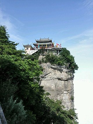
Tianshui is the second-largest city in Gansu Province, China. The city is located in the southeast of the province, along the upper reaches of the Wei River and at the boundary of the Loess Plateau and the Qinling Mountains. As of the 2020 census, its population was 2,984,659 inhabitants, of which 1,212,791 lived in the built-up area made of the 2 urban districts of Qinzhou and Maiji. The city and its surroundings have played an important role in the early history of China, as still visible in the form of historic sites such as the Maijishan Grottoes.

<span class="mw-page-title-main">Longnan</span> Prefecture-level city in Gansu, Peoples Republic of China

Longnan is a prefecture-level city in the southeast of Gansu province in China. It borders Sichuan on its south and Shaanxi on its east. As of the 2020 Chinese census, the population of the prefecture-level city was 2,855,555.

<span class="mw-page-title-main">Qin'an County</span> County in Gansu, China

Qin'an County is a county in the east of Gansu province, China. It is under the administration of the prefecture-level city of Tianshui. Its postal code is 741600, and in 1999 its population was 567,553 people. As of 2018, the population is 618,000 people. It is one of the poorest counties of Gansu, being appointed as one of 23 counties part of a provincial poverty alleviation project.

<span class="mw-page-title-main">Gangu County</span> County in Gansu, China

Gangu County is a county in the southeast of Gansu province, China. It is under the administration of Tianshui City and is the most populous county in Gansu. Its postal code is 741200, and in 1999 its population was 570,318 people.

<span class="mw-page-title-main">Jingyuan County, Gansu</span> County in Gansu, China

Jingyuan County is a county in the east of Gansu Province. It is under the administration of Baiyin City, and consists of two separate tracts of territory to the north and south of Pingchuan District. The northern tract borders Ningxia to the north. The southern area consists of an irrigated area around the Yellow River and the northern area is semi-arid highlands.

<span class="mw-page-title-main">Ning County</span> County in Gansu, China

Ning County or Ningxian is a county in the east of Gansu province, China. It is under the administration of the prefecture-level city of Qingyang. Its postal code is 745200, and its population in 1999 was 505,660 people.

<span class="mw-page-title-main">Kang County</span> County in Gansu, China

Kang County or Kangxian is a county in the southeast of Gansu province, China. It is under the administration of Longnan City. The county was formed in 1928 as Wudu County, but renamed to Kang County the next year, named after the northern Zhou Dynasty place Kangzhou.

<span class="mw-page-title-main">Siwa culture</span>

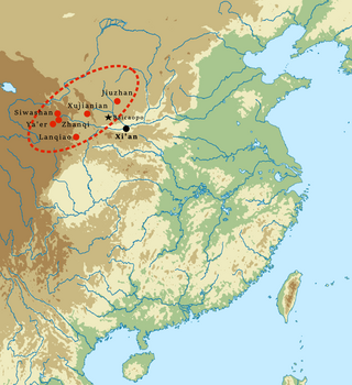
The Siwa culture was a Bronze Age culture in southeast Gansu Province, China. It was discovered by Swedish geologist Johan Gunnar Andersson in 1924 at Mount Siwa (寺洼山) in Lintao County, hence its name. It flourished circa 14th to 11th century BC, it is tentatively attributed to the cultures of the Northern Di, Qiang, and Xunyu peoples.

Qin Zhong or Zhong of Qin ,nomen unknown, was the fourth ruler of the state of Qin during China's Zhou dynasty. Qin at the time was a small fief that had been granted to his great-grandfather Feizi for his work breeding horses for King Xiao of Zhou. Qin Zhong succeeded his father Gongbo, who died in 845 BC. Their ancestral name was Ying.

Duke Zhuang of Qin was from 821 to 778 BC the fifth ruler of the Zhou Dynasty state of Qin that eventually united China to become the Qin Dynasty. His ancestral name was Ying and His Nomen is Qi.

Duke Xiang of Qin aka by his nomen ,Ying Kai ,was from 777 to 766 BC the sixth ruler of the Zhou Dynasty vassal state of Qin, which eventually unified China to become the Qin Dynasty. His ancestral name was Ying ,Kai as his nomen and Duke Xiang was his posthumous title. He was the first Qin ruler to be granted a nobility rank by the king of Zhou; under his reign, Qin was formally recognized as a major vassal state of Zhou China.

Duke Wen of Qin was the seventh ruler of the Zhou Dynasty state of Qin that eventually united China to become the Qin Dynasty. His ancestral name was Ying, nomen not known,and Duke Wen was his posthumous title.

Longxi Commandery was a commandery of imperial China in present-day Gansu, named due to its location west of Mount Long.

Tianshui Commandery, known as Hanyang Commandery during the Eastern Han dynasty, was a historical commandery of China in eastern Gansu. The modern city of Tianshui receives its name from the commandery.

<span class="mw-page-title-main">Yiqu</span>

Yiqu, was an ancient Chinese state which existed in the Hetao region and what is now Ningxia, eastern Gansu and northern Shaanxi during the Zhou dynasty, and was a centuries-long western rival of the state of Qin. It was inhabited by a semi-sinicized people called the Rong of Yiqu, who were regarded as a branch of western Rong people by contemporary writers, whom modern scholars have attempted to identify as one of the ancestors of the minority people in Northwest China.

<span class="mw-page-title-main">China National Highway 567</span> Road in China

China National Highway 567 runs from Lixian to where it meets G345 in Changba, Kangxian. Large parts of the route are relabeled from Gansu provincial highways S205 and S219. G7011 Shiyan–Tianshui Expressway runs parallel to the road on several sections. It is one of the new trunk highways proposed in the China National Highway Network Planning.

The 1654 Tianshui earthquake occurred on July 21 in Tianshui, Gansu Province, Ming dynasty sometime between 21:00 and 23:00 local time. The event had an estimated moment magnitude of 7.0 and was assigned a maximum intensity of XI on the China seismic intensity scale. Resulting in extreme damage and affecting at least four provinces, the quake killed approximately 30,000 people.

References

  1. National Bureau of Statistics of the People's Republic of China. Cited in Geohive. "China  Gansu Sheng Archived 2013-01-27 at the Wayback Machine ". 2013. Accessed 5 December 2013.
  2. Teichman, Eric. "Routes in Kan-su". The Geographical Journal, No. 48, p. 474. Op. cit. Dudbridge (2012).
  3. 《现代地质》 [Xiàndài Dìzhí, Modern Geology], Vol. 23, No. 34. 武汉地质学院北京研究生院 [Wǔhàn Dìzhí Xuéyuàn Běijīng Yánjiūshēngyuàn], 2009. (in Chinese)
  4. 中国气象数据网 – WeatherBk Data (in Simplified Chinese). China Meteorological Administration . Retrieved 27 August 2023.
  5. "Experience Template" 中国气象数据网 (in Simplified Chinese). China Meteorological Administration . Retrieved 27 August 2023.
  6. "China: Huaniu apples seize market with their high quality". 12 October 2017.
  7. 1 2 An C.B. & al. "Lanzhou University: Evolution of prehistoric agriculture in central Gansu Province, China: A case study in Qin'an and Li County", Chinese Science Bulletin, Vol.55, No.18, pp.1925 ff. (2010), excerpted in Issues in General Science and Scientific Theory and Method, 2011 ed., p.641.
  8. 1 2 3 4 Li Feng. Landscape and Power in Early China: The Crisis and Fall of the Western Zhou, 1045771BC, pp. 264 ff. Cambridge University Press (Cambridge), 2006. Accessed 3 December 2013.
  9. Sima Qian. Records of the Grand Historian translated by William Nienhauser Jr. as The Grand Scribe's Records: The Basic Annals of Pre-Han China, p. 88. Indiana University Press, 1994. Accessed 4 December 2013.
  10. Not Zhongyu. [9]
  11. 1 2 3 4 5 6 Sima Qian. Records of the Grand Historian , 《秦本纪》 ["Annals of Qin"]. Guoxue. Accessed 29 April 2012. (in Chinese)
  12. 1 2 3 4 5 Han Zhaoqi. Annotated Shiji, "Annals of Qin", pp. 345346. Zhonghua Book Co., 2010. ISBN978-7-101-07272-3.
  13. Li, p. 134.
  14. Traditional accounts made this rebellion a spontaneous reäction of the oppressed people of Hao, but it seems more likely to have been the result of a royal defeat in a power struggle with aristocrats in the Wei valley. [13]
  15. 1 2 Dudbridge, Glen. A Portrait of Five Dynasties China: From the Memoirs of Wang Renyu (880956), pp. 8 ff. Oxford University Press (Oxford), 2013. Accessed 14 Dec 2013.
  16. Derbyshire, Edward. Loess Letter: The Skin of the Earth and the Way of the World, No. 21 (Supplement), p. 17. Center for Loess Research and Documentation (Leicester), 1989.
  17. The Monitoring Service of the British Broadcasting Corporation. Summary of World Broadcasts: Far East , Vol. 3. "A Grain-deficient County in Kansu". BBC, 1977.
  18. China.org. "94 Dead in Gansu Quake". 23 July 2013. Accessed 3 December 2013.
  19. "甘肃礼县:创新精准扶贫模式 纵深推进精准脱贫". www.moa.gov.cn. Retrieved 2024-02-05.
  20. "【数说甘味】药中将军——礼县大黄-新华网". m.xinhuanet.com. Retrieved 2024-02-05.
  21. https://nync.gansu.gov.cn/nync/c107907/202310/173779357.shtml.{{cite web}}: Missing or empty |title= (help)
  22. "礼县:发展绿色经济 做优生态文明大文章_来稿选登_中国甘肃网". gansu.gscn.com.cn. Retrieved 2024-02-05.
  23. 2023年统计用区划代码和城乡划分代码:礼县 (in Simplified Chinese). National Bureau of Statistics of China.