
The River Liffey is a river in eastern Ireland that ultimately flows through the centre of Dublin to its mouth within Dublin Bay. Its major tributaries include the River Dodder, the River Poddle and the River Camac. The river supplies much of Dublin's water and supports a range of recreational activities.

The Northside is the part of Dublin city that lies to the north of the River Liffey. It is an informal but commonly used term. While it is sometimes regarded as less wealthy than the city's Southside, the Northside was originally the home of the city's upper classes and the more privileged of the two. Today, some of the wealthiest areas in Ireland lie north of the river, such as Malahide, Howth, Clontarf, and Castleknock.
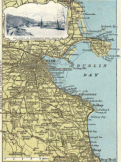
Dublin Bay is a C-shaped inlet of the Irish Sea on the east coast of Ireland. The bay is about 10 kilometres wide along its north–south base, and 7 km in length to its apex at the centre of the city of Dublin; stretching from Howth Head in the north to Dalkey Point in the south. North Bull Island is situated in the northwest part of the bay, where one of two major inshore sand banks lay, and features a 5 km long sandy beach, Dollymount Strand, fronting an internationally recognised wildfowl reserve. Many of the rivers of Dublin reach the Irish Sea at Dublin Bay: the River Liffey, with the River Dodder flow received less than 1 km inland, River Tolka, and various smaller rivers and streams.

The Grand Canal is the southernmost of a pair of canals that connect Dublin, in the east of Ireland, with the River Shannon in the west, via Tullamore and a number of other villages and towns, the two canals nearly encircling Dublin's inner city. Its sister canal on the Northside of Dublin is the Royal Canal. The last working cargo barge passed through the Grand Canal in 1960.

Ringsend is a southside inner suburb of Dublin, Ireland. It is located on the south bank of the River Liffey and east of the River Dodder, about two kilometres east of the city centre. It is the southern terminus of the East Link Toll Bridge. Areas included in Ringsend are the south side of the Dublin Docklands, and at the west end is the area of South Lotts and part of the Grand Canal Dock area. Neighbouring areas include Irishtown, Sandymount and the Beggars Bush part of Ballsbridge to the south, and the city centre to the west. A key feature of the area is the chimneys of Poolbeg power station.
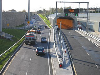
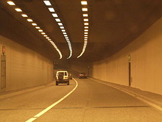
The Dublin Tunnel, originally and still commonly known as the Port Tunnel, is a road traffic tunnel in Dublin, Ireland, that forms part of the M50 motorway.
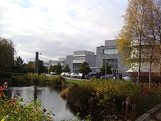
East Point Office Park in the docklands area of Dublin, Ireland is one of the country's largest business parks, being the place of employment for thousands of people. It is situated in the East Wall area on reclaimed land.
Celbridge is a town and townland on the River Liffey in County Kildare, Ireland. It is 23 km (14 mi) west of Dublin. Both a local centre and a commuter town within the Greater Dublin Area, it is located at the intersection of the R403 and R405 regional roads. As of the 2016 census, Celbridge was the third largest town in County Kildare by population, with over 20,000 residents.

The River Dodder is one of the three main rivers in Dublin, Ireland, the others being the Liffey, of which the Dodder is the largest tributary, and the Tolka.

The West-Link is a toll bridge on the M50 motorway to the west of Dublin, Ireland, operated by Emovis for Transport Infrastructure Ireland.

Straffan is a village in County Kildare, Ireland, situated on the banks of the River Liffey, 25 km upstream of the Irish capital Dublin. As of the 2016 census, the village had a population of 853, a nearly two-fold increase since the 2006 census.

The Avoca is a river in County Wicklow, Ireland. It is contained completely within the county. Its length is 35 miles (56.3 km).
The Jack Lynch Tunnel is an immersed tube tunnel and an integral part of the N40 road network in Cork, Ireland. It is named after former Taoiseach, Jack Lynch, a native of Cork.

Liffey Valley Shopping Centre is a shopping center located in Dublin 22, Ireland which Comprises 80 stores and 20 Restaurants. The centre opened on 14 October 1998 and is located near the junction of the M50 motorway and N4 road closely surrounded by Lucan to the west, Palmerstown Village to the east and Clondalkin to the south. The centre was a scaled-down replacement for a much larger complex once mooted for the site, known as Quarryvale, the development of which was highly controversial. After over a decade without major development, the centre was extended in 2016.

Dublin 15, also rendered as D15, is a postal district in the suburbs of Dublin in Fingal, Ireland. It is 11 km (6.8 mi) west of the GPO in Dublin city.

Kippure at 757 metres (2,484 ft), is the 56th-highest peak in Ireland on the Arderin scale, and the 72nd-highest peak on the Vandeleur-Lynam scale. Kippure is situated in the far northern sector of the Wicklow Mountains, where it lies on the border of the counties of Dublin and Wicklow in Ireland. Kippure is the County Top for Dublin, and its height and positioning over Dublin city have made its summit an important site for transmission masts, which are highly visible from a distance. Kippure's slopes feed into the Liffey Head Bog which forms the source of the River Liffey. The summit can be easily accessed from the east via a path that lies off the R115 road along the route to the Sally Gap.
The Niagara Tunnel Project was part of a series of major additions to the Sir Adam Beck hydroelectric generation complex in Niagara Falls, Ontario, Canada.

The R115 road is a regional road in counties Dublin and Wicklow in Ireland. It follows the Military Road for its entire length. The R115 is 40.5 km (25.2 mi) long; the full length of the Military Road is 57.9 km (36.0 mi).

