Likoma District

Last updated
Location of Likoma District in Malawi MW-Likoma.png
Location of Likoma District in Malawi

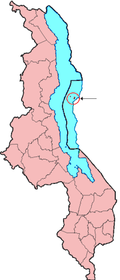
Likoma District is the least populous district of Malawi, which consists of two separate exclaves of Malawi situated within Mozambican waters in Lake Malawi (also known in Tanzania as Lake Nyasa and in surrounding Mozambique as Lago Niassa). It consists of two main islands, Likoma and Chizumulu. It is a district in the Northern Region of Malawi. The capital is Likoma. The district covers an area of 20 km², and has a population of 14,527 [1] .

Contents

History

Whereas Portuguese missionaries colonized the interior of Angola and Mozambique in the 19th century, Anglican missionaries colonized Malawi, including the islands in Lake Malawi.

In 1954, an agreement was made to make the middle of Lake Malawi the border between Malawi and neighboring Mozambique; however, Likoma and Chizumulu islands were kept as part of Malawi. [2]

Demographics

At the time of the 2018 Census of Malawi, the distribution of the population of Likoma District by ethnic group was as follows: [1]

Culture

The Likoma people are mostly fishermen and speak a traditional Nkamanga language. There are mostly small villages on both islands, with the exception of Mbamba with an Anglican cathedral. [2] There are few cars but plenty of four-wheelers, creating a unique blend of tourism and local culture. [3]

Geography

The district covers an area of 20 km2 and has a population of 14,527 at the 2018 Census. The population density is thus approximately 726 people per square kilometre. [4] It is the smallest of Malawi's districts. There is one airport, on the main island. [5]

Satellite view of the Likoma District. Likoma (satellite).jpg
Satellite view of the Likoma District.

Main Towns

Government and administrative divisions

There is a single National Assembly constituency representing the Likoma Islands:

Since the 2009 election it has been held by O. A. Thundu of the Democratic Progressive Party. [7]

Politics

The district was visited by none of the dozen presidential hopefuls in the 2014 election cycle, which locals took as a sign of discouragement. [8]

Climate

Most of the island is grassland, and the dominant trees are baobab tree and the mango tree. Animal life is made up of small amphibians, birds, and some of the most diverse fish life in Malawi. [2]

Related Research Articles

<span class="mw-page-title-main">Demographics of Malawi</span> Demographics of the country

Demographic features of the population of Malawi include population density, ethnicity, education level, health of the populace, economic status, religious affiliations and other aspects of the population.

<span class="mw-page-title-main">Transport in Malawi</span>

Transportation in Malawi is poorly developed. The country of almost 14 million has 39 airports, 6 with paved runways and 33 with unpaved runways. It has 797 kilometres of railways, all narrow-gauge and about 45 percent of its roads are paved. Though it is landlocked, Malawi also has 700 km (435 mi) of waterways on Lake Malawi and along the Shire River.

<span class="mw-page-title-main">Lake Malawi</span> African Great Lake

Lake Malawi, also known as Lake Nyasa in Tanzania and Lago Niassa in Mozambique, is an African Great Lake and the southernmost lake in the East African Rift system, located between Malawi, Mozambique and Tanzania.

<span class="mw-page-title-main">Nkhotakota</span> Place in Central Region, Malawi

Nkhotakota (Un-kho-tah-kho-tuh) is a town and one of the districts in the Central Region of Malawi. It is on the shore of Lake Malawi and is one of the main ports on Lake Malawi. As of 2018, Nkhotakota had a population estimated at 28,350. The district had a population of 301.000.

<span class="mw-page-title-main">Monkey Bay</span> Place in Southern Region, Malawi

Monkey Bay or Lusumbwe is a town in Mangochi which is in the Mangochi District in the Southern Region of Malawi. The town is on the shore of Lake Malawi and is one of the main ports on Lake Malawi. The population of Monkey Bay was 14,955 according to the 2018 census. Monkey Bay is 206 kilometres (128 mi) from Lilongwe, Malawi's capital city, and 253 kilometres (157 mi) from Blantyre. Monkey Bay is a tourist resort and is often travelled through on the road to Cape Maclear.

<span class="mw-page-title-main">Northern Region, Malawi</span> Region of Malawi

The Northern Region is a region of Malawi. It had a population of 2,289,780 in 2018, and covers an area of 26,931 km², making it the smallest region both by population and area. Its capital city is Mzuzu. Starting in the north and going clockwise, the Northern Region borders on Tanzania, Lake Malawi, Malawi's Central Region, and Zambia.

<span class="mw-page-title-main">Likoma Island</span> Island in Lake Malawi

Likoma Island is the larger of two islands in Lake Malawi, in East Africa, the smaller being the nearby Chizumulu. Likoma and Chizumulu both belong to Malawi, and together they make up the Likoma District. Although both islands lie just a few kilometres from Mozambique, and are entirely surrounded by Mozambican territorial waters, they are both exclaves of Malawi.

<span class="mw-page-title-main">Chizumulu Island</span> Island in Malawi

Chizumulu Island is the smaller of two islands in Lake Malawi, the larger being the nearby Likoma island, which together make up the Likoma District. Both these islands lie just a few kilometres from Mozambique and are entirely surrounded by Mozambican territorial waters, but they belong to Malawi. They are therefore exclaves of Malawi. This came about because the islands were colonised by Anglican missionaries spreading east from Nyasaland, rather than by the Portuguese who colonised Mozambique. The British originally claimed the entire Lake Nyasa/Lake Malawi, but in 1954 signed an agreement with Portugal, which recognized the centre of the lake as the boundary between their holdings and Mozambique, and making these islands an enclave.

Dedza is a district in the Central Region of Malawi. It covers an area of 3,754 km.² to the south of the Malawi capital, Lilongwe, between Mozambique and Lake Malawi and has a population of 830,512. The capital is Dedza.

<span class="mw-page-title-main">Ntcheu District</span> District of Malawi

Ntcheu is a district in the Central Region of Malawi. It borders with the country of Mozambique. The district headquarters is Ntcheu, known as BOMA in the local language, but is most commonly called Mphate. It is run by Yeneya, the village headman. The district covers an area of 3,424 km.² and has a population of 659,608 people according to the 2018 Malawi Population and Housing Census. The Ntcheu district lies around halfway between Malawi's majors cities of Blantyre and Lilongwe - the capital city.

Nkhotakota is a district in the Central Region of Malawi. The capital is Nkhotakota. The district covers an area of 4,259 km² and has a population of 395,897. The word Nkhotakota means "zig-zag" in Chichewa. It is located along the shore of Lake Malawi.

<span class="mw-page-title-main">Eastern Province, Zambia</span> Province of Zambia

Eastern Province is one of Zambia's ten provinces. The province lies between the Luangwa River and borders with Malawi to the east and Mozambique to the south, from Isoka in the northeast to the north of Luangwa in the south. The provincial capital is Chipata. Eastern province has an area of 51,476 km2 (19,875 sq mi), locally shares border with three other provinces of the country and is divided into fifteen districts.

<span class="mw-page-title-main">Likoma, Malawi</span> Place in Northern Region, Malawi

Likoma is the main town on Likoma Island in Malawi. It is the administrative capital of Likoma District.

<span class="mw-page-title-main">Nkhata Bay</span> Place in Northern Region, Malawi

Nkhata Bay or just Nkhata is the capital of the Nkhata Bay District in Malawi. It is on the shore of Lake Malawi, east of Mzuzu, and is one of the main ports on Lake Malawi. The population of Nkhata Bay was 14,274 according to the 2018 census. Nkhata Bay is 413 kilometres (257 mi) from Lilongwe, Malawi's capital city, and 576 kilometres (358 mi) from Blantyre, Malawi's second-largest city. Nkhata Bay is the second "busiest resort" on Lake Malawi.

<span class="mw-page-title-main">Universities' Mission to Central Africa</span> Former Anglo-Catholic missionary society

The Universities' Mission to Central Africa was a missionary society established by members of the Anglican Church within the universities of Oxford, Cambridge, Durham, and Dublin. It was firmly in the Anglo-Catholic tradition of the Church, and the first to devolve authority to a bishop in the field rather than to a home committee. Founded in response to a plea by David Livingstone, the society established the mission stations that grew to be the bishoprics of Zanzibar and Nyasaland, and pioneered the training of black African priests.

<span class="mw-page-title-main">Chauncy Maples</span> Anglican missionary

Chauncy Maples was a British clergyman and Anglican missionary who became Bishop of Likoma, with a diocese in East Africa.

<span class="mw-page-title-main">William Percival Johnson</span> Anglican missionary; translated the Bible into Chinyanja

William Percival Johnson was an Anglican missionary to Nyasaland. After education at Bedford School (1863–1873) and graduation from University College, Oxford, he went to Africa with the Universities' Mission to Central Africa, under the Bishop Edward Steere.

<span class="mw-page-title-main">Christianity in Malawi</span>


According to the 2018 census, 77.3% of the population is Christian. Denominations include Roman Catholics at 17.2% of the total population, Central Africa Presbyterians at 14.2%, Seventh-day Adventist at 9.4%, Anglicans at 2.3%, Pentecostals at 7.6% and other denominations at 26.6%.

Likoma Airport is an airport on Likoma Island, Republic of Malawi. The island lies in Lake Malawi a few kilometres off the shore of Mozambique.

<span class="mw-page-title-main">Malosa (Malawi)</span>

Malosa is a small trading centre located in the Zomba District of Malawi. The Malosa mountain range and plateau neighbours the more famous Zomba Plateau and is separated by the Domasi Valley. Malosa is on the M3, 27 km from the city of Zomba. The earth road from the trading post leads from the edge of the main road right up to the base of the Malosa mountain range.

References

  1. 1 2 2018 Malawi Population and Housing Census Main Report
  2. 1 2 3 "Likoma Island - Hot locations". www.travelmalawiguide.com. Retrieved 2016-11-17.
  3. Travel, Tribes. "Likoma Island | Tribes Travel". www.tribes.co.uk. Retrieved 2016-11-17.
  4. "Nkhata Bay-Likoma Districts Infographics" (PDF). PRB. Retrieved 17 November 2016.
  5. "Map of airports in Likoma Island District, Malawi @ OurAirports". ourairports.com. Retrieved 2016-11-17.
  6. "Likoma District, Malawi - list of cities, towns, villages". www.citipedia.info. Retrieved 2016-11-17.
  7. "Parliament of Malawi - Members of Parliament - Likoma District". Archived from the original on 2011-07-17. Retrieved 2011-01-19.
  8. Botha, Patrick (2014-05-17). "Malawi: No Presidential Hopeful Visits Likoma District to Campaign - Voters Feel Sidelined". Malawi News Agency (Lilongwe). Retrieved 2016-11-17.

12°05′S34°40′E / 12.083°S 34.667°E / -12.083; 34.667