In the United Kingdom and Ireland, a county town is the most important town in a county. It is usually the location of administrative or judicial functions within a county and the place where the county's members of Parliament are elected. Following the establishment of the English county councils in 1889, the headquarters of the new councils were usually located in the county town of each county. However, the concept of a county town pre-dates the establishment of these councils.
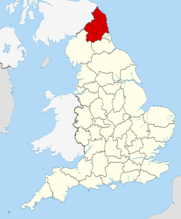
Northumberland is a unitary authority and historic county in North East England. The northernmost county of England, the unitary authority borders Cumbria to the west, County Durham and Tyne and Wear to the south and the Scottish Borders to the north. To the east is the North Sea coastline with a path 103 kilometres (64 mi) long. The county town is Alnwick, although the county council is based in Morpeth.

Lilburn is a city in Gwinnett County, Georgia, United States. The population was 11,596 at the 2010 census. The estimated population was 12,644 in 2018. It is a developed suburb of Atlanta and a part of the Atlanta metropolitan area.

Northumberland County is an upper tier level of municipal government situated on the north shore of Lake Ontario, east of Toronto in Central Ontario.

Morpeth is a historic market town in Northumberland, North East England, lying on the River Wansbeck. Nearby villages include Mitford, Clifton and Pegswood. In the 2011 census, the population of Morpeth was given as 14,017, up from 13,833 in the 2001 census. The earliest record of the town is believed to be from the Neolithic period. The meaning of the town's name is uncertain, but it may refer to its position on the road to Scotland and a murder which occurred on that road. An alternative origin is a derivation of 'murderers' path' from the time when the gallows were on the Common. The de Marley family was granted the Barony of Morpeth in c. 1080 and built two castles in the town in the late 11th century and the 13th century. The town was granted its coat of arms in 1552. By the mid 1700s it had become one of the main markets in England, having been granted a market charter in 1199, but the opening of the railways in the 1800s led the market to decline. The town's history is celebrated in the annual Northumbrian Gathering.
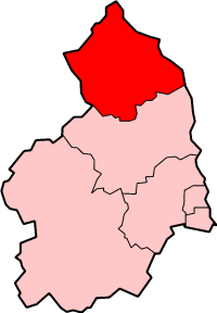
Berwick-upon-Tweed was a local government district and borough in Northumberland in the north-east of England, on the border with Scotland. The district had a resident population of 25,949 according to the 2001 census, which also notes that it is the most ethnically homogeneous in the country, with 99.6% of the population recording themselves in the 2001 census as White. It was also the smallest district in England with borough status, and the third-least densely populated local government district.

Northumberland County Council is a unitary authority in North East England. The population of the non-metropolitan unitary authority at the 2011 census was 316,028.
Sir Edward Foyle CollingwoodLLD was an English mathematician and scientist. He was a member of the Eglingham branch of a prominent Northumbrian family, the son of Col. Cuthbert Collingwood of the Lancashire Fusiliers, whose family seat was at Lilburn Tower, near Wooler, Northumberland. His great grandfather was a brother of Admiral Lord Collingwood.

Lilburn Tower is a privately owned 19th century mansion house at Lilburn, near Wooler, Northumberland. The property is a Grade II* listed building and forms part of the Lilburn Estate. A number of discrete buildings and monuments are scattered across the grange, including the Hurlestone, Hurlestone Tower, and an astronomical observatory.

The BAPS Shri Swaminarayan Mandir in Atlanta, Georgia is a traditional Hindu mandir, or place of worship, inaugurated on 26 August 2007 by the BAPS Swaminarayan Sanstha, a denomination of the Swaminarayan branch of Hinduism headed by Mahant Swami Maharaj. The mandir located in the Lilburn suburb of Atlanta, was constructed in accordance with ancient Hindu architectural scriptures, and is the largest mandir of its kind outside of India. The mandir is made of 34,450 pieces of hand-carved Italian marble, Turkish Limestone and Indian pink sandstone, situated on landscaped grounds spread over 30 acres. The mandir complex also includes a large assembly hall, family activity center, classrooms, and an exhibition on the key tenets of Hinduism. The mandir is open daily for worship and to visitors of any faith.
England Counties XV is a representative rugby union team, formed in 2002, that is open to English players who play in the County Championship and the third tier of the English rugby union system. Players from the Premiership and RFU Championship are ineligible.

The House of Lilburn are an ancient family historically seated as Lords of the Manor in Northumberland, United Kingdom. The family name Lilburn derives from the original home of the family, Lilburn, Northumberland. Furthermore, the etymology of the name itself, a combination of the words lily and burne (river), derives from the nature of the Lilburn area, which is described as being by the 'stream where the lillies grow'.

Bedlington railway station was a railway station that served the town of Bedlington, Northumberland, England from 1850 to 1964 on the Blyth and Tyne Railway. The station was closed by British Railways in 1964, but it has been the subject of a reopening campaign since at least the 1990s.

Bebside railway station was a railway station that served the village of Bebside, Northumberland, England from 1850 to 1964.
Newsham railway station was a railway station that served the village of Newsham near Blyth, England from 1851 to 1964 on the Blyth and Tyne Railway. It was located at the junction of the Percy Main to Blyth and Bedlington lines of the Blyth and Tyne Railway. The station was closed by British Railways in 1964, but it has been the subject of a reopening campaign since at least the 1990s.
Seaton Delaval railway station was a railway station that served the village of Seaton Delaval, Northumberland, England from 1841 to 1965 on the Blyth and Tyne Railway.
Woodhorn was a railway station proposed as part of the project to reintroduce passenger rail services onto the Ashington, Blyth & Tyne Railway which closed to passenger traffic in 1964. It was initially proposed that the newly reopened line could terminate at a new station, close to the Woodhorn Colliery Museum and Northumberland Archives, rather than at Ashington, the previous station however revised plans, released in July 2019 appear to have dropped Woodhorn station from project scope.
