
McAllen International Airport is in McAllen, in Hidalgo County, Texas, United States.

Lubbock Preston Smith International Airport is five miles north of Lubbock, in Lubbock County, Texas, United States. Originally Lubbock International Airport, it was renamed in 2004 for former Texas governor Preston E. Smith, an alumnus of Texas Tech University.

Billings Logan International Airport is in the western United States, two miles northwest of downtown Billings, in Yellowstone County, Montana. It is the fourth largest airport in Montana, having been surpassed in recent years by Bozeman, Missoula, and Flathead County (Kalispell) in both number of gates as well as annual enplanements. Owned by the city of Billings, the airport is on top of the Rims, a 500-foot (150 m) cliff overlooking the downtown core, and covers 2,500 acres of land.
Lea County Regional Airport is four miles (6.4 km) west of Hobbs, in Lea County, New Mexico, United States. The airport covers 898 acres (363 ha) and has three runways. It is an FAA certified commercial airport served by United Airlines' affiliate with daily regional flights. Lea County Regional Airport is the largest of the three airports owned and operated by Lea County Government. Lea County also owns and operates two general aviation airports in Lovington and Jal, New Mexico.
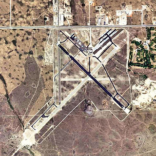
Yuma International Airport is a joint use airport with civilian and military flight activity operated in conjunction with the U.S. Marine Corps via the Marine Corps Air Station Yuma. The airfield is located 3.5 miles south of the central business district of Yuma, a city in Yuma County, Arizona, United States, and 150 miles east of San Diego International Airport. It is mostly used for military aviation, but is also served by one commercial airline and one aeromedical Medevac company as well as being used for general aviation activities.

Montgomery Regional Airport is a civil-military airport seven miles southwest of Montgomery, the capital of Alabama. Owned by the Montgomery Airport Authority, it is used for general aviation and military aviation, and sees two airlines.

North Central West Virginia Airport is a public/military airport a mile northeast of Bridgeport and six miles east of Clarksburg, in Harrison County, West Virginia, United States. It is owned and operated by the Benedum Airport Authority, serving Harrison and Marion County, and was formerly Benedum Airport and Harrison-Marion Regional Airport. The airport sees two airlines, with some passenger service subsidized by the Essential Air Service program.

Mid-Ohio Valley Regional Airport is seven miles northeast of Parkersburg, in Wood County, West Virginia. It is owned by the Wood County Airport Authority and is also known as Wood County Airport or Gill Robb Wilson Field. It serves the Mid-Ohio Valley area which includes the Ohio cities of Marietta and Belpre and the West Virginia cities of Williamstown, Parkersburg and Vienna. It has scheduled passenger service subsidized by the Essential Air Service program.

Williamsport Regional Airport serves Williamsport, Pennsylvania, and the surrounding area with a population of roughly 200,000. The airport processes approximately 40,000 passengers annually and has served north central Pennsylvania since 1929.

Wichita Falls Regional Airport is a public and military use airport six miles north of Wichita Falls in Wichita County, Texas. Its runways and taxiways are shared with Sheppard Air Force Base; most operations are military, but American Eagle flies to Dallas/Fort Worth International Airport.

Wilmington Airport is an airport located in unincorporated New Castle County, Delaware, near Wilmington, Delaware. Owned by New Castle County and operated under a lease agreement with the Delaware River and Bay Authority, it is five miles (8 km) south of Wilmington and about 30 miles (50 km) from Philadelphia. It is included in the Federal Aviation Administration (FAA) National Plan of Integrated Airport Systems for 2017–2021, in which it is categorized as a non-hub primary commercial service facility.

Greater Portsmouth Regional Airport is on State Route 335 in Minford, Ohio, 12 miles northeast of Portsmouth, in Scioto County, Ohio. It is owned by the Scioto County Airport Authority. The National Plan of Integrated Airport Systems for 2011–2015 categorized it as a general aviation facility.

Zanesville Municipal Airport is a city-owned airport six miles east of downtown Zanesville, in Muskingum County, Ohio. The National Plan of Integrated Airport Systems for 2011–2015 called it a general aviation facility.

Eastern West Virginia Regional Airport, also known as Shepherd Field, is a civilian-owned, public use airport located four nautical miles south of the central business district of Martinsburg, a city in Berkeley County, West Virginia, United States. It is owned by the Eastern West Virginia Regional Airport Authority or EWVRAA. This airport is included in the National Plan of Integrated Airport Systems for 2011–2015, in which the Federal Aviation Administration categorized it as a reliever airport.

Lebanon-Warren County Airport is a public airport located three miles (5 km) northwest of the central business district of Lebanon, on Greentree Road, in Warren County, Ohio, United States.
Wheeling Ohio County Airport is a public airport serving Wheeling and Ohio County, West Virginia, United States. It is eight miles (13 km) northeast of downtown Wheeling and is owned by the Ohio County Commission.

Mid-State Regional Airport is a small airport in Rush Township, Centre County in Pennsylvania, between Black Moshannon State Park to the east and Moshannon State Forest.

Findlay Airport is 1 mile (1.6 km) southwest of Findlay, in Hancock County, Ohio.

Syracuse Hancock International Airport is a joint civil–military airport five miles (8 km) northeast of downtown Syracuse, New York, and 65 miles (100 km) south of Watertown. Operated by the Syracuse Department of Aviation, it is located off Interstate 81, near Mattydale. The main terminal complex is at the east end of Colonel Eileen Collins Boulevard. Half of the airport is located within the Town of DeWitt, with portions in the towns of Salina and Cicero.

Terre Haute Regional Airport is a civil-military public airport in Terre Haute, in Vigo County, Indiana, six miles (9.7 km) east of the city center. The FAA's National Plan of Integrated Airport Systems for 2011–2015 categorized it as a general aviation facility. It is also the location of Hulman Field Air National Guard Base of the Indiana Air National Guard.

