Limbuwan

Last updated
Limbuwan
CountryFlag of Nepal.svg    Nepal
Nepal region Eastern Nepal
Area
  Total6,316 sq mi (16,358 km2)
Population
 (2011)
  Total387,300 [1]

Limbuwan is an area of the Himalayan region historically made up of 10 Limbu kingdoms, now part of eastern Nepal. Limbuwan means "abode of the Limbus" or "Land of the Limbus". [2] Limbuwan was incorporated into the Kingdom of Nepal by means of a collective Gorkha-Limbuwan Treaty with the kings of the ten Limbuwan kingdoms and their ministers.

Contents

The ten kingdoms formed after the great revolution of Limbuwan in the 6th century. It was collectively decided to name the land by the name of "Limbuwan." The current state of Limbu nation, culture, language and ethnicity is believed to have taken shape during this period. The northern boundary was fixed to be in Tibet, the southern boundary in JalalGarh in Bihar, the eastern boundary at the river Teesta and the western boundary at the Dudhkoshi River. [3]

In modern times, the boundaries of Limbuwan came to rest at the Arun river in the west and Kanchenjunga mountain and the Mechi river in the east. This area covers nine districts : Jhapa, Ilam, Panthar, Taplejung, Morang, Sunsari, Dhankuta, Terhthum and Sankhuwashava. From the time of King Sirijunga Hang to King Mahendra of Nepal, Limbuwan enjoyed the Kipat system of land and semi or full autonomy. [4]

A political movement in Nepal has developed which claims to territorial authority for a Limbuwan federal state in Nepal’s eastern borderland. [5] Eastern Nepal and the dominant ethnic groups of that region are indigenously called Kirat.[ citation needed ] The land was sub-divided into three regions, namely, the Wallo, Majh and Pallo Kirat.[ citation needed ] Limbuwan is also called Pallo-kirat 'Further Kirat'. [6]

History

9 Districts advocated by Federal Limbuwan State Council in dark blue, historic Limbuwan maximum extent light blue, thick lines represent current international boundaries. Federal Limbuwan State Council. Limbuwan location.png
9 Districts advocated by Federal Limbuwan State Council in dark blue, historic Limbuwan maximum extent light blue, thick lines represent current international boundaries. Federal Limbuwan State Council.

The Ten Kings of Limbus came together to formally declare all the ten kingdoms between the Arun River and Teesta River to be called "Yakthung Laaje".

The ten rulers, their kingdoms and their forts:

  1. Samlupi Samba Hang, King of Tambar and his capital Tambar Yiok.
  2. Sisiyen Shering Hang, King of Mewa and Maiwa kingdoms and his capital Meringden Yiok.
  3. Thoktokso Angbo Hang, King of Athraya and his capital Pomajong.
  4. Thindolung Khokya Hang, King of Yangwarok and his capital Hastapojong Yiok
  5. Yengaso Papo Hang, King of Panthar and his capital at Yashok and Pheden (Phe meaning "plain", den meaning "place").
  6. Shengsengum Phedap Hang, King of Phedap and his capital at Poklabung.
  7. Mung Tai Chi Emay Hang, King of Ilam and his capital at Phakphok.
  8. Soiyak LadhoHang Chemjong, King of Bodhey (Choubise) and his capital at Shanguri Yiok.
  9. Tappeso Perung Hang, King of Thala and his capital at Thala Yiok.
  10. Taklung Khewa Hang, King of Chethar and his capital at Chamling Chimling Yiok.

Rise of King Mawrong Hang

After a brief period, King Mawrong Hang came to prominence and took over Terai lands of Chethar, Bodhey, Panthar, and Ilam (present day Jhapa, Morang Sunsari and Dhankuta). He named his Kingdom Morang after his name and rose to power. He subdued all the Ten Limbu Kings of Limbuwan and became their overlord. He died without any male heir and King Uba Hang took over as supreme ruler of Limbuwan in 849 AD- 865 AD. He made many religious and social reforms in Limbuwan. Uba Hang's worthy son Mabo Hang succeeded him in 865 AD and ruled till 880 AD. Uba Hang kept on with the reforms his father had started. Uba Hang was succeeded by his son Muda Hang. Muda Hang was a weak ruler so the local chiefs started ruling their areas independently. Muda Hang was succeeded by his son Wedo Hang, by this time Limbuwan was in chaos and every principality was ruling independently and fighting with each other. Wedo hang was murdered and his son Chemjonghang succeeded.

Rise of King Sirijonga Hang

During this chaos and the waning phase of King Chemjong hang, King Sirijonga of Yangwarok kingdom rose to power. He subdued all the independent rulers and took over as the new supreme ruler of Limbuwan. He built two big forts in Phedap (present-day Terhathum district) and Chainpur (present-day Sankhuwasabha district). The remains of the structure still stand today. One of legacy was that he brought all the Limbus under the same writing system in Limbu script. He also brought feudal reform in Limbuwan and divided Limbuwan into new boundaries and districts.

Eventually after the establishment of Namgyal dynasty in Sikkim and under the Lho-Mehn-Tsong Tsum, a treaty between the Bhutia, Lepcha and Limbu people of the Sikkim area, Limbuwan lost the area between Kangchenjunga range (present-day eastern border of Nepal) and Teesta River to the Bhutia Kings of Sikkim. Since then Limbuwan comprises all the area between Arun River and Koshi River in the west to Kunchenjunga Mountains and Mechi River in the east.

At the beginning of the 15th century, the descendants of King Sirijonga hang became weak and Limbuwan again fell into chaos and anarchy. At the time, the two Yakthung Ing brothers from Kamrup Assam, had come and proclaimed the independent country of Phedap, Pokblabang and Bijayapur, Morang. The elder brother Sidi Ing became king of Poklabang, Phedap and the Lowland Limbuwan Kingdom of Morang was King Sangla Ing. After the 17th generations of the King Sidi Ing , got a glorius king Tena Hang. He had seven sons and called them as "Satre Nu hang" or "Sat Raya." Among of them Yen Hang Mukpa Raya was the king of Phedap and the descendants of him goes on "Sambahangphe" Limbus. The 21st descendant of King Sidi Ing, named Aatahang Raya made a treaty with Gorkha king Prithvi Narayan Shah in 1774 A.D. Some of the descendants of Yen Hang Mukpa Raya were not in favor of the treaty with Gorkha kings because they wanted to make their own territorial ruling system in great Yakthung Laje .

The other brother King Sangla Ing declared independence and became the first independent ruler of Morang in a century. His son Pungla Ing adopted Hinduism and changed his Hindu name into Aamar Raya Ing. He was succeeded by his descendants, who also bore Hindu names. Kirti Narayan Raya Ing, Aap Narayan Raya Ing, Jarai Narayan Raya Ing, Ding Narayan Raya Ing, and Bijay Narayan Raya Ing.

King Bijay Narayan Raya Sanlga Ing built a new town in the middle of Varatappa and Shangori fort and named it Bijaypur after him. He had no issue and died without an heir.

Bijaypur town was founded in 1584 AD and is currently located next to Dharan, Sunsari District. Bijaypur town remained the capital of Morang Kingdom and Limbuwan region until the Limbuwan-Gorkha War in 1774 AD.

Morang Kingdom was the most powerful and influential of all the Kingdoms in Limbuwan region and was able to establish its hegemony among all the other Limbu rulers. But in 1609 AD Sen King Lohang Sen of Sen dynasty captured Morang and ruled it for seven generations.

King of Phedap Murray Hang Khebang was made the chief minister of Morong. He stayed in Bijaypur and the King of Morong made his post hereditary. Murray Hang Khebang was given a Hindu name and he became Bidya Chandra Raya. His descendants remained Chief Ministers of Morong until Buddhi Karna Raya Khebang. Buddhi Karna succeeded the last Sen King of Morang Kama Datta sen and sat in the throne of Bijaypur Palace in 1769 AD.

Annexation into Nepal

Meanwhile, the Gorkha King Prithivi Narayan Shah was on a campaign to conquer all the hill kingdoms into his Empire. He attacked Limbuwan on two fronts. After the Limbuwan Gorkha War 1771-1774 AD, the Limbu ministers of Morong, and Limbu rulers of the ten principalities came to an agreement with the King of Gorkha. With the Limbuwan Gorkha treaty of 1774, Limbuwan was annexed to Nepal.

Limbuwan was attacked several times by Sikkim after 1774 AD. Battle of Morong during the British Gurkha war took place in Morong. Limbuwan was divided into present-day administrative districts in Panchayat era by King Mahendra.

Aboriginal inhabitants

The original inhabitants of Limbuwan are the Yakthung and Yakkha people From the establishment of Limbuwan, these cultures have maintained their independent identity in Limbuwan coexisting peacefully with each other. [7] Today, there is a movement for regional autonomy.

Immigration

The later arrivals are Newars, Bahuns as missionaries of Hindu religion in the 1790s during the reign of King Prithivi Narayan Shah, Pratap Singh Shah and Rana Bahadur Shah. The Gurungs, Magars and chhetris living in Limbuwan are also later arrivals who came as soldiers of Gorkha King during the Limbuwan Gorkha War in the 1780s. The Madheshi settlers moved north and east from the Mithila region in the west, and thus also came during this time to cultivate the terai lands of Limbuwan. [8]

Limbus have become minorities, or they have become homeless/landless in their own Homeland due to mass migration. [9] The arrival of the non-limbu settler was part of a policy instituted by Kathmandu encouraging the immigration of Hindus into Limbuwan. [10] Limbus, for their part, were urged to settle these emigrants of their lands. [11]

The Limbuwan Gorkha War was a series of battles fought between the King of Gorkha and the rulers of various principalities of Limbuwan from 1771 to 1774 AD. The war came to an end in 1774 with the Limbuwan Gorkha treaty which recognized Limbu peoples' right to Kipat land in Limbuwan and full autonomy. History of Limbuwan covers the rest of the Limbuwan History.

After the conquest of Majh Kirant (Khambuwan /Rai kingdoms) by the Gorkhas, they invaded Limbuwan on two fronts. One front was in Chainpur (present-day Sankhuwasabha District) and the second front was in Bijaypur (present-day Dharan, Sunsari District). Bijaypur was the capital of the Morang the Kingdom of Limbuwan.

Migration of the Limbus

Archival research for the period 1830 to 1917 reveals that the British administrators were conscious that the Limbus were indigenous to Sikkim. [12] Only small portion of Limbus migrated into Sikkim in 18th century. [13] Following the end of Sikkim-Gorkha war at Limbuwan, the Gorkha officers started searching Limbus who had sided with the Sikkimese King or Sikkhim Kingdon. To weaken the Limbu collective power, Gorkha officers falsely accused of many Limbus of betraying Gorkha Kingdon; then, they captured, tortured, and executed a huge number of Limbus. Seeing this, all the Limbus who had fought against the Gorkhas by siding with the Sikkimese King, they assembled and decided to leave Limbuwan forever. About 32,000 in number and migrated in three groups. The first group went to Sikkim and settles in Rung, Rhino and Magnesia villages, the second group migrated to Bhutan and settled in Kuching, Tendu, and Jumsa villages and third group migrated to Assam and settles in Beni, Kalchini and other Meche and Koch villages.

Related Research Articles

The Limbu or Yakthung (endonym) are a Tibeto-Burman ethnolinguistic group indigenous to the Himalayan region of eastern Nepal, Sikkim, Assam, Nagaland, northern West Bengal, and western Bhutan.

<span class="mw-page-title-main">Yakkha people</span> Ethnic group of South Asia

Yakkha is an indigenous ethnic group from the Indian subcontinent, mainly in modern-day Nepal and present-day India. It is one of the descendants of Nepal's prehistoric Kirat dynasty. The Yakkha people are subsistence farmers who inhabit the lower Arun valley in eastern Nepal. They number only a few thousand and their language is nearly extinct.

<span class="mw-page-title-main">History of Sikkim</span>

The history of Sikkim begins with the indigenous Lepcha's contact with early Tibetan settlers. Historically, Sikkim was a sovereign Monarchical State in the eastern Himalayas. Later a protectorate of India followed by a merger with India and official recognition as a state of India. Lepchas were the main inhabitants as well as the Ruler of the land up to 1641. Lepchas are generally considered to be the first people, indigenous to Sikkim also includes Darjeeling.

<span class="mw-page-title-main">Ilam District</span> District in Koshi Province, Nepal

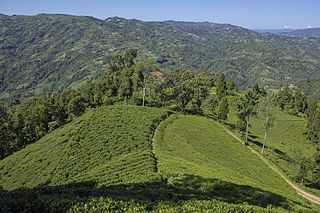
Ilam district is one of 14 districts of Koshi Province of eastern Nepal. It is a Hill district and covers 1,703 km2 (658 sq mi). The 2011 census counted 290,254 inhabitants. The municipality of Ilam is the district headquarters and is about 600 km (370 mi) from Kathmandu.

<span class="mw-page-title-main">Morang District</span> District in Nepal

Morang District is located in Koshi Province in eastern Nepal. It is an Outer Terai district, which borders Jhapa to the east, Dhankuta and Panchthar to the north, Sunsari to the west, and Bihar, India, to the south. Morang has one metropolitan city (Biratnagar), eight municipalities and eight rural municipalities. The total area of the district is 1,855 km2 (716 sq mi). The lowest elevation point is 60 meters and the highest is 2,410 meters above sea level. The headquarters of Morang is connected by the Koshi National Highway to the east–west Mahendra National Highway at Itahari, Sunsari. Morang is also connected to the Hill parts of the eastern region of Nepal. Morang is the core industrial sector for the eastern region of Nepal.

<span class="mw-page-title-main">Sunsari District</span> District in Koshi province

Sunsari District is one of 14 districts in Koshi province of eastern Nepal. The district is located in the eastern part of the Outer Terai and covers an area of 1,257 km2 (485 sq mi). According to the 2011 Nepal census, the population was 753,328. The district headquarters is located in Inaruwa.

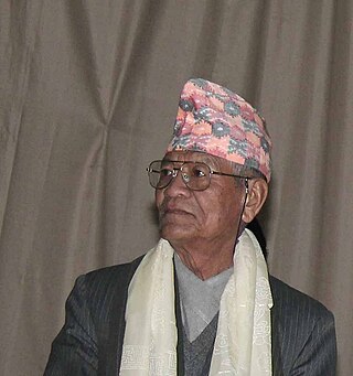
Iman Xin Chemjong Limbu, or Iman Singh Chemjong Limbu; was a Limbu historian, writer, linguist, lexicographer, folklorist, and philosopher of Nepal. Chemjong devoted his entire life to studying and documenting various facets of Kirat Limbu tradition and culture at a time when such activities were frowned upon and even punished by the Nepalese ruling elite as being subversive and "anti-national". Chemjong's research into and publication of Kirant history and culture challenged perceptions of the Nepalese official doctrine that showcased Nepal as a Hindu cultural monolith devoid of alternative narratives.

<span class="mw-page-title-main">Limbu language</span> Sino-Tibetan language of eastern Nepal and India

Limbu is a Sino-Tibetan language spoken by the Limbu people of Nepal and Northeastern India as well as expatriate communities in Bhutan. The Limbu refer to themselves as Yakthung and their language as Yakthungpan. Yakthungpan has four main dialects: Phedape, Chhathare, Tambarkhole and Panthare dialects.

<span class="mw-page-title-main">Kirati people</span> Indigenous ethnic groups of the Himalayas

The Kirati people, also spelled as Kirant, are Sino-Tibetan ethnolinguistic groups and indigenous peoples of the Himalayas, mostly the Eastern Himalaya extending eastward from Nepal to Northeast India (predominantly in the Indian States of Sikkim and Darjeeling & Kalimpong hills of northern West Bengal

The Limbuwan–Gorkha War was a series of battles fought between the king of Gorkha and the rulers of various principalities of Limbuwan from 1771 to 1774 AD. After the conquest of Majh Kirat and Wallo Kirat by the Gorkhas, they invaded Limbuwan on two fronts. One front was in Chainpur and the second front was in Bijaypur. Bijaypur was the capital of the Morang Kingdom of Limbuwan Yakthung Laje.

<span class="mw-page-title-main">Budha Subba Temple</span> Religious shrine in Nepal

Budha Subba Temple is a well known religious temple of the Nepali people. It is situated in Bijayapur of Dharan, Nepal. It is believed to fulfill the wishes and bring good luck to the people visiting there. According to Kirat historian Iman Singh Chemjong, Bijayapur was the capital of the then Limbuwan Kingdom of king Bijayanarayan Raya khebang. According to others, Bijayapur was named after King Bijaya.

History of Limbuwan is characterized by the close interaction of Limbuwan with its neighbours independent and semi-independent rule characterized by autonomy for most of its time.

Tye-Angsi Sirijanga Sing Thebe Limbu was an 18th-century Limbu scholar, educator, historian, linguist, leader, and philosopher of Limbuwan and Sikkim. He was formally known as Sirichongba and even more popularly known as "Sirijanga".

Chemjong is a Limbu surname. It is most common in Limbuwan, East Nepal, and Sikkim.

Yuma Sammang is the goddess of the Limbu community of Nepal. The deity Yuma Sammang also known as Ningwaphuma is the most important and popular among Yakthungs (Limbus) and worshiped in all occasion. Yuma is regarded as the mother by Yakthungs. Yuma Samyo or Yuma religion was very popular during Yet Hang age and Thibong Yakthung age.

<span class="mw-page-title-main">Bairagi Kainla</span> Nepalese poet and writer

Til Bikram Nembang Limbu, professionally known as Bairagi Kainla or Bairagi Kaila, is a Nepalese poet and litterateur. He has served as Chancellor of the Nepal Academy from 2009 to 2013. Part of his significant literary struggle was the Tesro Aayam movement. During the early 1960s, he, along with Ishwor Ballav and Indra Bahadur Rai, searched unexplored realms of Nepali literature and added a new dimension – the third dimension – to Nepalese literature.

<span class="mw-page-title-main">Koshi Province</span> Province of Nepal

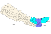
Koshi Province is the autonomous easternmost province adopted on 20 September 2015 by Constitution of Nepal. The province is rich in natural resources, tourist attractions, recreational activities, and natural beauty. The province covers an area of 25,905 km2 (10,002 sq mi), about 17.5% of the country's total area. With the industrial city of Biratnagar as its capital, the province includes major eastern towns of Birtamod, Sundar Haraincha, Damak, Dharan, Itahari, Triyuga Municipality and Mechinagar, and the Mount Everest, Kangchenjunga and Ama Dablam. Koshi River, the largest river of the nation, forms the province's western boundary. Under the First-past-the-post voting system issued by the Constituency Delimitation Commission, Nepal, the province hosts 28 parliamentary seats and 56 provincial assembly seats.

Buddhi Karna Raya was the last Limbu overlord king of Limbuwan. He was killed by the forces of Gorkhali king Prithvi Narayan Shah in AD 1774. The Limbuwan lands where he was king or overlord king were between Saptakoshi River to Kankai River covering present day three districts: Sunsari, Morang and parts of Jhapa. After Buddhi Karna's death the later kings in Limbuwan acknowledged the overlordship of the Gurkha King. It was about the time of Buddhi Karna's death that the Gorkha Kingdom was transformed into Nepal. His death was connected with the Limbuwan–Gorkha war.

<span class="mw-page-title-main">Swapnil Smriti</span>

Sanman Chemjong, who writes under the pen name Swapnil Smriti is a Nepali writer from Panchthar, Nepal. He is best known for his literary movement Multicolourism along with Dharmendra Bikram Nembang. He elevated the realm of postmodern literature to its new height in Nepal with the publication of his first collection of poems entitled Rangai Rangako Bheer in 2005 AD.

References

  1. Official Summary of Census (2011), Central Bureau of Statistics, Nepal Archived 2012-12-02 at the Wayback Machine
  2. P.46 National Costumes of Nepal By Persijs Muiznieks, 23 Aug 2011
  3. Chemjong, Imansingh. Kirat History and Culture.
  4. Jesse, Russell (2012). Limbuwan Gorkha War.
  5. P. 46. National Costumes of Nepal by Persijs Muiznieks, 23 Aug 2011.
  6. P.5 Democratic Innovations in Nepal: A Case Study of Political Acculturation By Bhuwan Lal Joshi, Leo E. Rose, 1966
  7. Routledge Handbook of Asian Borderlands By Alexander Horstmann, Martin Saxer, Alessandro Rippa Routledge, 9 Mar 2018
  8. Land Tenure and Taxation in Nepal: The Jagir, Rakam, and Kipat tenure systems By Mahesh Chandra Regmi, 1965
  9. Land Tenure and Taxation in Nepal: The Jagir, Rakam, and Kipat tenure systems By Mahesh Chandra Regmi, 1965
  10. P.54, land and social change in east Nepal By Lionel Caplan, 2000
  11. P.54, land and social change in east Nepal By Lionel Caplan, 2000
  12. Page 281 Readings in Indian Sociology: Volume VIII: Political Sociology of India By Anand Kumar, 31 Dec 2013
  13. Page 281 Readings in Indian Sociology: Volume VIII: Political Sociology of India By Anand Kumar, 31 Dec 2013

Other sources