Lincolnshire Wildlife Trust

Last updated
Banovallum House, Lincolnshire Wildlife Trust headquarters Lincolnshire Wildlife Trust HQ, Banovallum House, Horncastle - geograph.org.uk - 471676.jpg
Banovallum House, Lincolnshire Wildlife Trust headquarters

The Lincolnshire Wildlife Trust, (part of the Wildlife Trusts partnership), covers the whole ceremonial county of Lincolnshire, England. It was founded in 1948 as a voluntary charitable organisation dedicated to conserving the wildlife and wild places of Lincolnshire and to promoting the understanding and enjoyment of the natural world.

Contents

Description

Its headquarters are at Banovallum House, Manor House Street, Horncastle. It has over 27,000 members and manages 95 nature reserves with a total area of 8,520 acres (34.49 km2). These include five main visitor-focused reserves used for educational purposes:

The Trust employs 78 [5] full and part-time staff who are aided by more than 1,300 volunteers drawn mainly from Trust's 16 area groups (members' groups), each of which is based on one of the county's main towns. The area groups also organise meetings, visits and social events and are involved in fundraising and membership recruitment.

5,000 of the Trust's members are under 16 years of age; these are catered for by the organisation's junior wing Wildlife Watch which runs seven groups around the county organising events for children.

The Trust's income is derived mainly from members' subscriptions, money raised by area groups and members, donations, grants from local authorities and government agencies (usually for special projects), profits from the Trust's sales business and from legacies. [6]

Sites

Key

Public access

  • BPA = access only by prior arrangement with the Trust
  • No = no public access
  • Yes = public access to all or most of the site
SiteImageAreaLocationPublic AccessClassificationsDescription
Ancaster Valley 10 hectares (25 acres) 52°58′44″N0°32′09″W / 52.978924°N 0.53591996°W / 52.978924; -0.53591996 YesA steep-sided valley best known for its flower-rich limestone grassland. Plants include pasqueflower, bee orchid, dyer's greenweed and dropwort, whilst birds recorded at the site include Eurasian green woodpecker and great spotted woodpecker. [7]
Anderby Marsh 24 hectares (59 acres) 53°15′24″N0°19′19″E / 53.256569°N 0.32207716°E / 53.256569; 0.32207716
Arnold's Meadow 3 hectares (7.4 acres) 52°46′44″N0°07′59″E / 52.778972°N 0.13317943°E / 52.778972; 0.13317943
Banovallum House 1 hectare (2.5 acres) 53°12′28″N0°07′10″E / 53.207712°N 0.11933892°E / 53.207712; 0.11933892
Barrow Blow Wells Barrow Blow Wells Nature Reserve - geograph.org.uk - 1006466.jpg 3 hectares (7.4 acres) 53°41′03″N0°22′39″W / 53.684185°N 0.37762291°W / 53.684185; -0.37762291 YesLNRReedmarshes and woodland centred around two blow wells (natural artesian springs). [8]
Barrow Haven Reedbed Barrow Haven Reedbed - geograph.org.uk - 285827.jpg 13 hectares (32 acres) 53°41′53″N0°23′50″W / 53.697929°N 0.39716479°W / 53.697929; -0.39716479 YesLNRReedbed in flooded, disused clay pits.
Baston Fen Baston Fen Nature Reserve - geograph.org.uk - 404244.jpg 33 hectares (82 acres) 52°44′38″N0°18′19″W / 52.743907°N 0.30529738°W / 52.743907; -0.30529738
Bloxholm Wood 30 hectares (74 acres)
Boston Road Bricks 2 hectares (4.9 acres)
Boultham Mere 19 hectares (47 acres)
Candlesby Hill Quarry 2 hectares (4.9 acres)
Chapel Pit 3 hectares (7.4 acres)
Clapgate Pits 1 hectare (2.5 acres)Former quarry
Crowle Moor 188 hectares (460 acres)
Dawson City Clay Pits Dawson City Clay Pits Nature Reserve at Skitter Ness - geograph.org.uk - 10812.jpg 16 hectares (40 acres)
Deeping Lakes Deeping Lakes NR near Peterborough - geograph.org.uk - 162224.jpg 71 hectares (180 acres) 52°39′24″N0°15′02″W / 52.656675°N 0.25064869°W / 52.656675; -0.25064869 YesLNR, SSSIFlooded former gravel pits. Wildfowl and wetland site.
Digby Corner 1 hectare (2.5 acres)
Dole Wood 8 hectares (20 acres)
Donna Nook National Nature Reserve Donna Nook Seals and Warning Sign - geograph.org.uk - 761157.jpg 1,150 hectares (2,800 acres) 53°28′29″N000°09′07″E / 53.47472°N 0.15194°E / 53.47472; 0.15194 YesNNRCoastal salt marsh noted for its annual grey seal breeding population. [9]
Duke's Covert and Copper Hill 2 hectares (4.9 acres)
Epworth Turbary 33 hectares (82 acres)
Fairfield Pit 9 hectares (22 acres)
Far Ings National Nature Reserve Lake near Far Ings Road - geograph.org.uk - 305746.jpg 59 hectares (150 acres) 53°41′49″N0°27′36″W / 53.696838°N 0.45998523°W / 53.696838; -0.45998523 YesNNR, SSSI, Ramsar siteReedbeds on flooded former clay pits. Wildfowl and wetland site.
Fir Hill Quarry 1 hectare (2.5 acres)
Fiskerton Fen Fiskerton Fen Nature Reserve - geograph.org.uk - 319386.jpg 7 hectares (17 acres)
Frampton Marsh RSPB Frampton Marsh.jpg 172 hectares (430 acres) 52°55′35″N0°01′36″E / 52.9263°N 0.0266°E / 52.9263; 0.0266
Friskney Decoy Wood 6 hectares (15 acres)
Furze Hill 5 hectares (12 acres)
Gibraltar Point National Nature Reserve Gibraltar Point National Nature Reserve - geograph.org.uk - 1022055.jpg 437 hectares (1,080 acres) 53°05′47″N0°19′42″E / 53.09641°N 0.32838°E / 53.09641; 0.32838 NNR
Goslings Corner Wood 10 hectares (25 acres)
Great Casterton Road Banks Great Casterton Road Banks 5.jpg 1 hectare (2.5 acres) 52°39′47″N0°30′50″W / 52.663°N 0.514°W / 52.663; -0.514
Greetwell Hollow 13 hectares (32 acres)
Hatton Meadows 4 hectares (9.9 acres)
Haxey Turbary 15 hectares (37 acres)
Heath's Meadows 6 hectares (15 acres)
Hopland's Wood 14 hectares (35 acres)
Horbling Line 1 hectare (2.5 acres)
Huttoft Bank Pit 4 hectares (9.9 acres)
Keal Carr 12 hectares (30 acres)
Killingholme Haven Pits 32 hectares (79 acres)
Kingerby Beck Meadows 9 hectares (22 acres)
Kirkby Gravel Pits 15 hectares (37 acres)
Kirkby Moor 75 hectares (190 acres)
Landholme Wood 11 hectares (27 acres)
Lawn Wood, and Bottleneck and Jackson's Meadows 12 hectares (30 acres)
Legbourne Wood 35 hectares (86 acres)
Linwood Warren 28 hectares (69 acres)
Messingham Sand Quarry 40 hectares (99 acres)
Mill Hill Quarry 2 hectares (4.9 acres)
Moor Closes 6 hectares (15 acres)
Moor Farm 48 hectares (120 acres)
Moulton Marsh 36 hectares (89 acres)
Muckton Wood 17 hectares (42 acres)
Pasture Wharf 21 hectares (52 acres)
Pickering's Meadow 3 hectares (7.4 acres)
Pinchbeck Slipe 22 hectares (54 acres)
Rauceby Warren 9 hectares (22 acres)
Red Hill 27 hectares (67 acres)
Rigsby Wood 15 hectares (37 acres)
Robert's Field 4 hectares (9.9 acres)
Roughton Moor Wood 10 hectares (25 acres)
Rush Furlong 3 hectares (7.4 acres)
Saltfleetby – Threddlethorpe Dunes Saltfleetby National Nature Reserve - geograph.org.uk - 1038303.jpg 951 hectares (2,350 acres) 53°24′08″N0°12′23″E / 53.4023°N 0.2064°E / 53.4023; 0.2064 NNR
Sandilands Pit 1 hectare (2.5 acres)
Scotton Common 64 hectares (160 acres)
Sedge Hole Close 1 hectare (2.5 acres)
Silverines Meadows 6 hectares (15 acres)
Snipe Dales Snipe Dales meridian plaque.JPG 87 hectares (210 acres) 53°11′46″N0°00′18″W / 53.196°N 0.005°W / 53.196; -0.005
Sotby Meadows 6 hectares (15 acres)
South Witham Verges 6 hectares (15 acres)
Sow Dale 34 hectares (84 acres)
Spendluffe Meadows 5 hectares (12 acres)
Stanton's Pit Stantons Pit Nature Reserve - geograph.org.uk - 203228.jpg 8 hectares (20 acres)LNR
Swinn Wood 20 hectares (49 acres)LNR
Surfleet Lows 3 hectares (7.4 acres)
Tetney Blow Wells 15 hectares (37 acres)
The Shrubberies 5 hectares (12 acres)
Thurlby Fen Slipe 8 hectares (20 acres)
Toby's Hill 9 hectares (22 acres)
Toft Tunnel 3 hectares (7.4 acres)
Tortoiseshell Wood and Porter's Lodge Meadows 21 hectares (52 acres)
Tunman Wood 53 hectares (130 acres)
Watts Wood 3 hectares (7.4 acres)
Welton-le-Wold 2 hectares (4.9 acres)
Whisby Nature Park Whisby Nature Park.jpg 144 hectares (360 acres)
Willoughby Branch Line 5 hectares (12 acres)
Willoughby Meadow 5 hectares (12 acres)
Willow Tree Fen 112 hectares (280 acres)
Wolla Bank Pit 4 hectares (9.9 acres)
Wolla Bank Reedbed 3 hectares (7.4 acres)
Woodhall Spa Airfield Nature Reserve RAF Woodhall Spa (geograph 3022013).jpg 53°07′51″N0°11′56″W / 53.130728°N 0.19893587°W / 53.130728; -0.19893587 BPANNRFormer airfield and gravel quarry.

Related Research Articles

National nature reserves in England

National nature reserves in England are designated by Natural England as key places for wildlife and natural features in England. They were established to protect the most significant areas of habitat and of geological formations. NNRs are managed on behalf of the nation, many by Natural England itself, but also by non-governmental organisations, including the members of The Wildlife Trusts partnership, the National Trust, and the Royal Society for the Protection of Birds.

Loch Leven (Kinross)

Loch Leven is a fresh water loch located immediately to the east of the burgh of Kinross in Perth and Kinross council area, central Scotland. Roughly triangular, the loch is about 6 km (3.7 mi) at its longest. Prior to the canalisation of the River Leven, and the partial draining of the loch in 1826–36, Loch Leven was considerably larger. The drop in water level by 1.4 m reduced the loch to 75% of its former size, and exposed several small islands, as well as greatly increasing the size of the existing ones.

Bridgend County Borough County borough in Wales

Bridgend County Borough is a county borough in the south-east of Wales. The county borough has a total population of 139,200 people, and contains the town of Bridgend, after which it is named. Its members of the Senedd are Sarah Murphy MS, representing the Bridgend Constituency, and Huw Irranca-Davies MS representing the Ogmore Constituency, and its members of UK parliament are Jamie Wallis and Chris Elmore.

Gibraltar Point

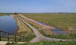
Gibraltar Point national nature reserve is an area of about 4.3 km2 (1.7 sq mi) on the coast of Lincolnshire, England.

Hatton, Lincolnshire Small village and civil parish in the East Lindsey district of Lincolnshire, England

Hatton is a small village and civil parish in the East Lindsey district of Lincolnshire, England. It is situated 3 miles (5 km) east from the town of Wragby, 6 miles (10 km) north-west from the town of Horncastle, and just north from the A158 road.

Corrieshalloch Gorge

Corrieshalloch Gorge is a gorge situated about 20 km south of Ullapool, close to the junction of the A832 and A835 roads near Braemore in the Scottish Highlands. The gorge is approximately 1.5 km long, 60 m deep, and 10 m wide at its lip. The Abhainn Droma flows through Corrieshalloch, below which the landscape opens out into a broad, flat-bottomed glacial trough at the head of Loch Broom.

Great Fen Habitat restoration project in the United Kingdom

The Great Fen is a habitat restoration project being undertaken on The Fens in the county of Cambridgeshire in the United Kingdom. It is one of the largest restoration projects in the country, and aims to create a 3,700 hectare wetland and aims to connect Woodwalton Fen National Nature Reserve (NNR), Holme Fen NNR and other nature reserves to create a larger site with conservation benefits for wildlife and socio-economic benefits for people.

The following is a list of recreational walks in Kent, England.

Lincolnshire coast

The coast of Lincolnshire runs for more than 50 miles (80 km) down the North Sea coast of eastern England, from the estuary of the Humber to the marshlands of the Wash, where it meets Norfolk. This stretch of coastline has long been associated with tourism, fishing and trade.

Snipe Dales

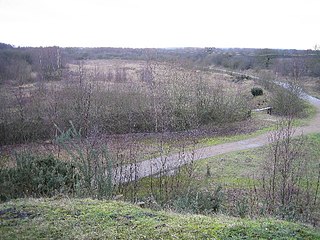
Snipe Dales is a country park and nature reserve in the Lincolnshire Wolds near Hagworthingham in Lincolnshire, England. The reserve is one of the few remaining examples showing the Wolds as they were.

Whisby Hamlet in Lincolnshire, England

Whisby is a hamlet in the civil parish of Doddington and Whisby, in the North Kesteven district of Lincolnshire, England. It is situated 5 miles (8.0 km) south-west from Lincoln city centre, 1.5 miles (2.4 km) south from Doddington, and 2 miles (3.2 km) north from the A46 road.

Whisby Moor is a small moor situated close to the A46 road, west of North Hykeham, in the North Kesteven district of Lincolnshire, England.

Malvern and Brueton Park

Malvern and Brueton Park is a town park and local nature reserve in Solihull in the West Midlands. The park is formed from a comparatively narrow strip of land, with the length being approximately ten times the average width, but it is looped forming a roughly U-shaped layout. The parks cover an area of approximately 130 acres (0.53 km2). Historically the park was formed by the joining of two separate parcels of different land. There is a large water feature, Brueton Park Lake, which runs through the southern end of the park, and is formed by the damming of a local watercourse, the River Blythe.

Idle Valley Nature Reserve

The Idle Valley Nature Reserve, also known as Lound Gravel Pits or Sutton and Lound Gravel Pits, is a wetland Site of Special Scientific Interest (SSSI) situated north-west of the town of Retford in the Bassetlaw district of north Nottinghamshire. The nature reserve is situated along the western bank of the River Idle and east of the villages of Sutton cum Lound and Lound. The nature reserve is managed by the Nottinghamshire Wildlife Trust.

Clyde Valley Woodlands National Nature Reserve

The Clyde Valley Woodlands National Nature Reserve (NNR) comprises six separate woodland sites in the Clyde Valley region of South Lanarkshire, Scotland. These six sites are located along a 12 km section of the River Clyde and its tributaries, and lie close to built-up areas such as Hamilton and Lanark on the southern outskirts of Greater Glasgow. The sites can be easily accessed by about two million people living in the surrounding urban areas, making the reserve unique amongst Scotland's NNRs, most of which tend to be located in more remote areas. The six sites are:

Bardney Limewoods

The Bardney Limewoods, part of the Lincolnshire Limewoods National Nature Reserve is a collection of small woodlands near Bardney in Lincolnshire. The reserve includes about half the Limewoods in the area. Cocklode Wood, part of the Bardney Limewoods, is the best surviving spread of medieval limes in England.

Central Gardens Nature Reserve

The Central Gardens Nature Reserve, also called Central Gardens, is a protected nature reserve located in the western suburbs of Sydney, New South Wales, Australia. Established in 1976, the 12-hectare (30-acre) reserve, garden and fauna and wildlife park is situated in the suburb of Merrylands and is managed by Cumberland Council. The park is regionally important and it attracts visitors outside the Cumberland local government area. The bushland contains remnants of Cumberland Plain Woodland and is approximately 3.5 hectares.

Far Ings National Nature Reserve

Far Ings national nature reserve is an area of over 90 ha on the southern shore of the Humber Estuary in North Lincolnshire, England. It is immediately west of the town of Barton-upon-Humber and the village of Barton Waterside. In addition to being designated as a national nature reserve, it is within the Humber Estuary Ramsar site, Site of Special Scientific Interest, Special Area of Conservation, and Special Protection Area.

Stodmarsh SSSI

Stodmarsh SSSI is a 623.2-hectare (1,540-acre) biological Site of Special Scientific Interest near Stodmarsh, north-east of Canterbury in Kent. Parts of it are a Nature Conservation Review site, Grade I, a National Nature Reserve, a Ramsar internationally important wetland site, a Special Area of Conservation and a Special Protection Area under the European Union Directive on the Conservation of Wild Birds.

References

  1. "Gibraltar Point NNR". Lincolnshire Wildlife Trust. Retrieved 4 May 2020.
  2. "Far Ings NNR". Lincolnshire Wildlife Trust. Retrieved 4 May 2020.
  3. "Whisby Nature Park". Lincolnshire Wildlife Trust. Retrieved 4 May 2020.
  4. "Snipe Dales". Lincolnshire Wildlife Trust. Retrieved 7 October 2019.
  5. "Meet the Team". Lincolnshire Wildlife Trust. Retrieved 4 May 2020.
  6. "LWT Annual Report 2018" (PDF). Lincolnshire Wildlife Trust. p. 13. Retrieved 4 May 2020.
  7. "Ancaster Valley". Lincolnshire Wildlife Trust. Retrieved 4 May 2020.
  8. "Barrow Blow Wells" (PDF). Lincolnshire Wildlife Trust. Retrieved 2 July 2020.
  9. "National Nature Reserves in Lincolnshire". Natural England. Retrieved 5 May 2020.