Lake Constance refers to three bodies of water on the Rhine at the northern foot of the Alps: Upper Lake Constance (Obersee), Lower Lake Constance (Untersee), and a connecting stretch of the Rhine, called the Lake Rhine (Seerhein). These waterbodies lie within the Lake Constance Basin in the Alpine Foreland through which the Rhine flows.

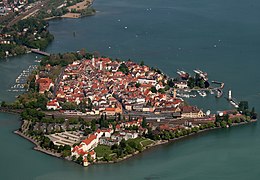
Lindau is a major town and island on the eastern side of Lake Constance in Bavaria, Germany. It is the capital of the county (Landkreis) of Lindau, Bavaria and is near the borders of the Austrian state of Vorarlberg, and the Swiss cantons of St. Gallen and Thurgau. The coat of arms of Lindau town is a linden tree, referring to the supposed origin of the town's name. The historic town of Lindau is located on the 0.68-square-kilometre (0.26 sq mi) island of the same name, which is connected with the mainland by a road bridge and a railway causeway leading to Lindau station.

Reichenau is a village in the municipality of Tamins in the Canton of Graubünden, Switzerland, where the two Rhine tributaries Vorderrhein and Hinterrhein meet, forming the Alpine Rhine.

The Alpine Rhine Valley is a glacial alpine valley, formed by the Alpine Rhine, the part of the River Rhine between the confluence of the Anterior Rhine and Posterior Rhine at Reichenau and Lake Constance. It covers three countries, with sections of the river demarcating the borders between Austria and Switzerland and between Liechtenstein and Switzerland. The full length of the Alpine Rhine is 93.5 km.

Reichenau Island is an island in Lake Constance in Southern Germany. It lies almost due west of the city of Konstanz, between the Gnadensee and the Untersee, two parts of Lake Constance. With a total land surface of 4.3 km2 (1.7 sq mi) and a circumference of 11 km (6.8 mi), the island is 4.5 km (2.8 mi) long and 1.5 km (0.93 mi) wide at its greatest extent. The highest point, the Hochwart, stands some 43 m (141 ft) above the lake surface and 438.7 m (1,439 ft) above mean sea level.

Mönchgut is a peninsula of 20.66 square kilometers with 1,374 inhabitants in the southeast of Rügen island in Mecklenburg-Western Pomerania, Germany. It lies just between the Greifswalder Bodden and the rest of the Baltic Sea. Mönchgut contains the districts of Göhren and Thiessow; the peninsula is part of the Mönchgut-Granitz administration area. It is also a part of the Biosphere Reserve of Südost-Rügen.

Altstadt and Lehel are districts of the German city of Munich. Together they form the first borough of the city: Altstadt-Lehel.

Reichenau is a municipality in the district of Konstanz in Baden-Württemberg in Germany. It is located partly on Reichenau Island with its famous abbey and on the northern shore of the Untersee section of Lake Constance. The island has historically been the center of the community. The administrative seat of the municipality is in the village of Mittelzell. A causeway built in 1838 connects the isle with the mainland. The municipality consists of the settlements Niederzell, Mittelzell und Oberzell on the island as well as Lindenbühl and Waldsiedlung on the shore.
The Buchloe–Lindau railway is a double-track, largely non-electrified main line in the German state of Bavaria. It runs through the Allgäu from Buchloe to Lindau in Lake Constance via Kaufbeuren and Kempten. Together with the connecting Munich–Buchloe railway it is known in German as the Bayerische Allgäubahn.

The Untersee, also known as Lower Lake Constance, is the smaller of the two lakes that together form Lake Constance and forms part of the boundary between Switzerland and Germany.

Werd Island is the main island of the small island group Werd Islands in the westernmost part of the Lower Lake of Lake Constance just before the High Rhine leaves the part of the lake known as Rheinsee. It is located on Swiss territory between Stein am Rhein and Eschenz.

The Dominican Island or Constance Island is an island in Lake Constance immediately east of the city of Constance. With an area of 1.8 hectares, it is one of the smaller islands in the lake. The island is separated from the city center by a six-metre-wide (20 ft) channel, and connected to it by a bridge. The island is dominated by the Steigenberger hotel, which is housed in the former Dominican convent.

Lindau-Insel station is the largest station in the city of Lindau (Bodensee) and was its most important station until passenger service resumed at Lindau-Reutin station on December 13, 2020. In the urban area there is also Lindau-Aeschach station and Lindau-Reutin freight yard. Formerly there were also Lindau-Siebertsdorf, Lindau Langenweg, Lindau Strandbad, Schoenau, Oberreitnau and Rehlings.

The nature reserve of Wollmatinger Ried – Untersee – Gnadensee is a protected area on the shores of Lake Constance in Germany. It has an area of 767 hectares and is the largest and most important nature reserve on the German side of Lake Constance. It is rich in plant and animal species and extends from the banks of the Seerhein river west of Constance via the causeway to the Island of Reichenau in the Untersee to the eastern Gnadensee near Allensbach-Hegne. The nearby offshore islands of Triboldingerbohl (Langenrain) and Mittler or Langbohl (Kopf) are part of the reserve.

Hoy is an uninhabited island in Lake Constance in Germany. It lies 400 metres east of the island of Lindau in the Bay of Reutin and 100 metres south of the lakeshore near the mouth of the Oberreitnauer Ach. With an area of 53 square metres it is the smallest island in Lake Constance.

The Vogelinsel is an island in Lake Constance with an area of around 600 square metres. It lies around 230 metres northwest of the mouth of the Leiblach opposite the Gemarkung of Reutin of the town of Lindau. On the island is the red mole beacon at the harbour entrance of the marina in Lindau-Zech. The island has been designated as a bird reserve.

The Winterthur–Romanshorn railway, also known in German as the Thurtallinie, is a Swiss railway line and was built as part of the railway between Zürich and Lake Constance (Bodensee). It connects Winterthur with Romanshorn, where it formerly connected to train ferries over Lake Constance. It is the fourth oldest internal railway in Switzerland. Its construction was to be funded by the Zürich-Lake Constance Railway (Zürich-Bodenseebahn), but during the construction the company was merged with the Swiss Northern Railway to form the Swiss Northeastern Railway. The Winterthur–Romanshorn railway was opened on 16 May 1855 and the line from Winterthur to Oerlikon was opened on 27 December 1855. Zürich was reached on 26 June 1856 and the two existing NOB lines were connected.

The Vorarlberg S-Bahn is a label for regional rail services in the Austrian state of Vorarlberg. It is integrated into the Vorarlberg Transport Association (VVV) which manages ticket pricing, and is operated by the state-owned ÖBB and privately owned Montafonerbahn (mbs). In addition to Vorarlberg, the network connects to the German town of Lindau, the Swiss towns of St. Margrethen and Buchs SG, and stations in the Principality of Liechtenstein.

Lindau-Reutin station is a junction station in the town of Lindau, where the Aeschach curve branches off from the Vorarlberg Railway (Lindau-Bregenz–Bludenz). It is also a border station with Austria. In the course of the reconstruction of the Lindau rail hub, which began in 2016, the rail facilities, which were last used only as a goods station, were expanded into Lindau's new long-distance train station, which went into operation in 2020. In contrast to the terminus station Lindau-Insel, which opened in 1854, the station in the most populous district Reutin is a through station on the mainland. A station for local passenger services opened at Lindau-Reutin as Lindau-Lokalbahnhof in 1876 and was known as Lindau-Ost from 1911 but the last passenger services to it ended in 1980. The station building is located on Bregenzer Straße, on a level with Berliner Platz.
The Friedrichshafen–Lindau railway is a single-track main-line railway in Southern Germany, that has been electrified since December 2021. It connects the rail junction of Friedrichshafen Stadt in Baden-Württemberg with Lindau in Bavaria, where it meets the Buchloe–Lindau railway at a junction in the district of Aeschach. The 22.575 kilometre-long line runs consistently on the north shore of Lake Constance (Bodensee), with the western part lying in Bodenseekreis and the eastern part in the district of Lindau. The line is part of the route known as the Bodenseegürtelbahn, connecting Radolfzell and Lindau-Insel.