Perthshire, officially the County of Perth, is a historic county and registration county in central Scotland. Geographically it extends from Strathmore in the east, to the Pass of Drumochter in the north, Rannoch Moor and Ben Lui in the west, and Aberfoyle in the south; it borders the counties of Inverness-shire and Aberdeenshire to the north, Angus to the east, Fife, Kinross-shire, Clackmannanshire, Stirlingshire and Dunbartonshire to the south and Argyllshire to the west. It was a local government county from 1890 to 1930.
Dunsmore is a name with a separate origin in Scotland and England.

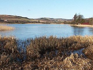
Lochwinnoch is a village in the council area and historic county of Renfrewshire in the west central Lowlands of Scotland. Lying on the banks of Castle Semple Loch and the River Calder, Lochwinnoch is chiefly a residential dormitory village serving nearby urban centres such as Glasgow and Paisley. Its population in 2001 was 2628.
Tillicoultry is a town in Clackmannanshire, Scotland. Tillicoultry is usually referred to as Tilly by the locals.
Newburgh is a royal burgh and parish in Fife, Scotland, at the south shore of the Firth of Tay. The town has a population of 2,171, which constitutes a 10% increase since 1901 when the population was counted at 1,904 persons.

Menstrie is a village in the county of Clackmannanshire in Scotland. It is about five miles east-northeast of Stirling and is one of a string of towns that, because of their location at the foothill base of the Ochil Hills, are collectively referred to as the Hillfoots Villages or simply The Hillfoots.

Mauchline is a town and civil parish in East Ayrshire, Scotland. In the 2001 census Mauchline had a recorded population of 4,105. It is home to the National Burns Memorial.
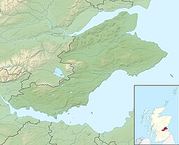
Lindores is a small village in Fife, Scotland, in the parish of Abdie, about 2 miles south-east of Newburgh. It is situated on the north-east shore of Lindores Loch, a 44 ha freshwater loch. A possible derivation of the name Lindores is 'church by the water'. The ruins of Abdie church, about 0.5 miles south-west of the village are possibly the site of an ancient shrine connected to the Celtic foundation at Abernethy. After the foundation of Lindores Abbey in 1191 the church was given to the abbey.

Sauchie is a town in the Central Lowlands of Scotland. It lies north of the River Forth and south of the Ochil Hills, within the council area of Clackmannanshire. Sauchie has a population of around 6000 and is located one mile northeast of Alloa and two miles east-southeast of Tullibody.
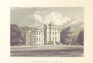
Airthrey Castle is a historic building and estate which now forms part of the buildings and grounds of the University of Stirling in central Scotland. The 18th-century building with 19th-century additions occupies a beautiful setting in landscaped grounds in the southern edge of the Ochil Hills, above the Forth valley. It is located close to Bridge of Allan, 2 miles from the historic city of Stirling.
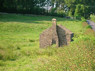
A curling house was used to store curling stones, brushes and other equipment used to maintain a curling pond and play the game of curling in Scotland and elsewhere.
Kilbirnie Loch, is a freshwater Loch situated in the floodplain between Kilbirnie, Glengarnock and Beith, North Ayrshire, Scotland. It runs south-west to north-east for almost 2 km (1.2 mi), is about 0.5 km (0.31 mi) wide for the most part and has an area of roughly 3 km2. It has a general depth of around 5.2 metres (17 feet) to a maximum of around 11 metres (36 feet). The loch is fed mainly by the Maich Water, which rises in the Kilbirnie Hills near Misty Law, and is drained by the Dubbs Water that runs past the Barr Loch into Castle Semple Loch, followed by the Black Cart, the White Cart at Renfrew and finally the River Clyde. The boundary between East Renfrewshire and North Ayrshire, in the vicinity of the loch, runs down the course of the Maich Water along the northern loch shore to then run up beside the Dubbs Water.

Lambroughton Loch or Wheatrig Loch was situated in a low-lying area between the farms and dwellings of Hillhead, Lambroughton, Wheatrig, Titwood and Lochridge mainly in the Parish of Dreghorn, North Ayrshire. The loch was mainly fed by the Lochridge Burn, the Garrier Burn and surface runoff, such as from the old rig and furrows indicated by Roy's maps of the mid-18th century. The loch outflow was via the Lochridge Burn that runs into the Garrier Burn, passes the site of the old Lochend habitation and into the Bracken Burn near Little Alton. The rivulet or watercourse is known as the Garrier Burn beyond this point.

Fail Loch or Faile Loch was situated in a low-lying area near the old monastery of Fail in the Parish of Tarbolton, South Ayrshire, Scotland. The old Lochlea Loch lies nearby and its waters still feed into Fail Loch via the Mill Burn.

The Blae Loch is a small freshwater loch situated in a hollow in a low-lying area beneath Blaelochhead Hill in the Parish of Beith, North Ayrshire, Scotland.
Martnaham Loch is a freshwater loch lying across the border between East and South Ayrshire Council Areas, two kilometres from Coylton, in the parishes of Coylton and Dalrymple, three miles from Ayr. The loch lies along an axis from northeast to southwest. The remains of a castle lie on a possibly artificial islet within the loch. The Campbells of Loudoun once held the lands, followed by the Kennedys of Cassillis.

Lowes Loch, The Lochs or Loch of Hill is now a small natural freshwater loch in the North Ayrshire Council Areas, lying in a glacial kettle hole, once of greater extent, lying below Brownmuir and Lochland Hills on the Threepwood Road, near Beith, in the Parish of Beith. The loch may once have had a small island within it.

Flisk was a parish in Fife, Scotland.

Abdie is a parish in north-west Fife, Scotland, lying on the south shore of the Firth of Tay on the eastern outskirts of Newburgh, extending about 3 miles eastwards to the boundary of Dunbog parish, with which it is now united ecclesiastically and for the Community Council. It is also bounded by Collessie on the south and has a small border with the parish of Moonzie in the south-east.